
Steimatzky

Steimatzky (1920 – present) is the oldest and largest bookstore chain in Israel. Founded by Tzvi Steimatzky in 1920, the first store was opened in Tel Aviv at 6 Hertzel Street. Steimatzky's half-brother Yechezkel Steimatzky opened the second store on Jaffa Road in Jerusalem in 1925. Yechezkel, a Russian-born immigrant from Germany, originally went to the British Mandate of Palestine for the opening of the Hebrew University of Jerusalem, but decided to stay after he saw the potential for success in opening a foreign language bookstore whose clients would be a growing population of immigrants along with British Army soldiers serving under the British Mandate. He found that the bookstore was so successful that he opened another store in Haifa the following year. By 1927, the Steimatzky brand had expanded outside the British Mandate, when a store opened in Beirut. During World War II, a Steimatzky store opened in Baghdad next to the British Army base, and branches in Cairo, Alexandria, and Damascus soon followed. After the outbreak of the 1948 Arab-Israeli War, the expansion throughout the Middle East came to an end. In 1948 another store opened in Tel Aviv on Allenby Street. Eri Steimatzky, Yechezkel's son, joined the company and became its general manager in 1963. By 2010, Steimatzky operated over 160 stores throughout Israel, dominating the market in Israel. By September 2017, however, the gap between Steimatzky and its closest competitor, Tzomet Sfarim, was closing; Steimatzky had reduced their number of branches to 140 compared to Tzomet Sfarim's 96 stores.
Illustrates the Old City and the Temple Mount in detail.
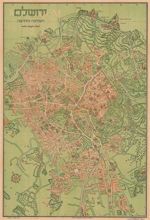
ירושלם העתיקה והחדשה / Jerusalem Old and New.
$600.00
Acquire
- Digital Map Information
- Suitable for large format printing
- Full resolution TIFF file
- ICC color profile embedded
- Delivered instantly via download link
This is a 1942 Steimatzky pictorial map of Jerusalem in Hebrew. The map depicts the city from Karem es Sila to El Tur and the Mount of Olives and from the Hadassa Medical Center, the Hebrew University and Mt. Scopus to Meqor Hayim. Illustrating numerous buildings in profile, the Old City and the Temple Mount act as the focal point. Surrounded by walls, several buildings within the Old City, such as the Holy Sepulcre, St. Anne's, the Supreme Muslim Council, and several gates are labeled. On the Temple Mount, the Dome of the Rock and the Al Aksa Mosque are illustrated. Some of the locations illustrated outside the Old City include the Citadel, the Church of Dormition, the Tomb of the Virgin, the Tombs of the Kings, and several monasteries and convents. Neighborhoods throughout the city are labeled, along with streets and the railway which enters the city near the bottom of the map. (more details)
The 1949 Armistice Agreement - 'the Green Line'.
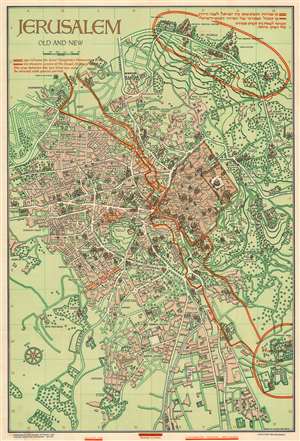
Jerusalem Old and New.
$650.00
Acquire
- Digital Map Information
- Suitable for large format printing
- Full resolution TIFF file
- ICC color profile embedded
- Delivered instantly via download link
This is a 1949 Steimatzky pictorial map of Jerusalem. The map boldly illustrates the 1949 'Green Line' (although it's illustrated here in red). The 'Green Line' separated Israeli and Jordanian-controlled areas of Jerusalem following the 1948 Arab-Israeli War. (more details)
Jerusalem under the Armistice.
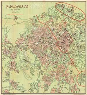
This is a 1955 Steimatzky pictorial map of Jerusalem. The map depicts the city from the Beth Hakerem neighborhood to the Mount of Olives and the Hill of Evil Counsel and from Mt. Scopus to the Meqor Hayim and Beth Mazmil neighborhoods. When this map was issued, the 1949 Armistice Agreement between Israel and Jordan was still in effect (the borders would remain the same until after the 1967 Six-Day War) and is here illustrated by a red line. (more details)