
Straube, Julius

Julius Straube (April 12, 1832 - October 24, 1913) was a German cartographer. Born in Berlin and the son of a master butcher, Straube began training as a military cartographer at the age of 15. Straube founded the Geographische Institut und Landkartenverlag Julius Straub on July 3, 1858 and ran the business until 1886, when his son Benno took over. Between the Wilhemina era and the First World War, Straube's business was the market leader among Berlin cartographic institution's, garnering a 36% market share. In 1885, Straube published his most impressive work, a monumental 44-sheet Overview Plan of Berlin. Beginning in 1900, the Straube firm began to see more competition in the marketplace, and in 1913 Benno Straube had insolvency proceedings opened against him. Julius Straube died six days later.
First specific map of Beyoğlu.
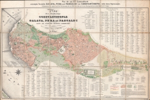
Plan des Faubourgs de Constantinople. Galata, Pera et Pancaldi uni au sixième district communal ainsi que leurs confins. / Plan der zum 6ten Communalbezirk vereinigten Vorstädte Galata, Pera und Pancaldi von Constantinople nebst deren Angrenzungen.
$4,000.00
Acquire
- Digital Map Information
- Suitable for large format printing
- File Size: 32.44 MB
- File Type: ZIP / TIFF
- ICC color profile embedded
- Delivered instantly via download link
This is a c. 1861 C. Stolpe city plan or map of Beyoğlu, Istanbul, Turkey. It is the oldest known map of Beyoğlu, in one of just three surviving examples. Today Beyoğlu is Istanubl's most fashionable neighborhood. (more details)