1861 Stolpe Folding Map of Beyoğlu, Istanbul, Turkey (1st Map of Beyoğlu)
GalataPeraPancaldi-stolpe-1861$4,000.00

Title
Plan des Faubourgs de Constantinople. Galata, Pera et Pancaldi uni au sixième district communal ainsi que leurs confins. / Plan der zum 6ten Communalbezirk vereinigten Vorstädte Galata, Pera und Pancaldi von Constantinople nebst deren Angrenzungen.
1861 (undated) 19.25 x 29.25 in (48.895 x 74.295 cm) 1 : 5000
1861 (undated) 19.25 x 29.25 in (48.895 x 74.295 cm) 1 : 5000
Description
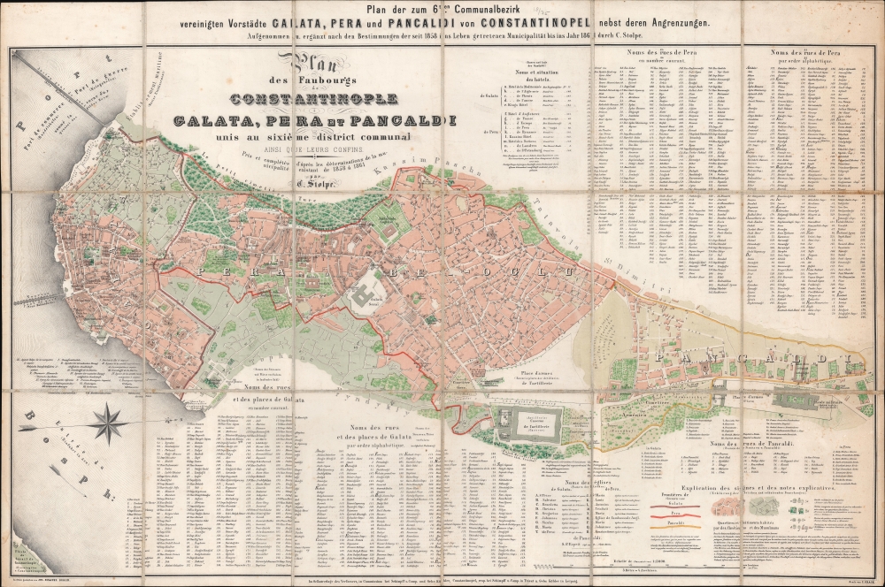
This is a c. 1861 C. Stolpe city plan or map of Beyoğlu, Istanbul, Turkey. It is the oldest known map of Beyoğlu, in one of just three surviving examples. Today Beyoğlu is Istanubl's most fashionable neighborhood.
A Closer Look
The map focuses on three quarters within Beyoğlu: Galata, Karaköy, and Kasımpaşa. Karaköy is not explicitly delineated but is part of Galata. Major streets are illustrated throughout, with hospitals, synagogues, consulates and embassies, theaters, markets, mosques, and churches labeled. Hundreds of other locations and streets are numerically identified and named in indexes specific to each quarter. Color coding differentiates between Christian and Muslim neighborhoods.Beyoğlu
People have lived in Beyoğlu since the 7th century BC. During the Renaissance, from 1273 to 1453, the Genoese maintained a trading colony here. During the latter Ottoman period, the quarter was widely regarded as a European zone, a fact that proved a draw to wealthy cosmopolitan Turks. In the 19th century (as here), Beyoğlu became a diplomatic zone, drawing multiple embassies and consulates. Pera (as it was then called) became one of the first areas of Constantinople to have electricity, trams, and telephone lines. Today, Beyoğlu is one of the most fashionable neighborhoods in Istanbul, home to nightclubs, restaurants, museums, art galleries, and elite shops.Publication History and Census
This map was drawn by Carl Stolpe, engraved in stone by Julius Straube, and printed by Carl Grack c. 1861. We note but two other surviving examples, one at the Staatsbibliothek zu Berlin and a second at the Dominican Study Institute in Istanbul. No market history.Cartographer
Julius Straube (April 12, 1832 - October 24, 1913) was a German cartographer. Born in Berlin and the son of a master butcher, Straube began training as a military cartographer at the age of 15. Straube founded the Geographische Institut und Landkartenverlag Julius Straub on July 3, 1858 and ran the business until 1886, when his son Benno took over. Between the Wilhemina era and the First World War, Straube's business was the market leader among Berlin cartographic institution's, garnering a 36% market share. In 1885, Straube published his most impressive work, a monumental 44-sheet Overview Plan of Berlin. Beginning in 1900, the Straube firm began to see more competition in the marketplace, and in 1913 Benno Straube had insolvency proceedings opened against him. Julius Straube died six days later. More by this mapmaker...
Condition
Very good. Dissected and mounted on linen in 18 panels. Light toning, soiling, and foxing.
References
OCLC 1081106601, 1291402086.