
Sundberg, Edwin L.

Edwin L. Sundberg (1898 - 1978) was an American cartographer known for his pictorial pieces. Sundberg was a staff artist for the Sunday News in New York City and eventually became Chief Cartographer in charge of a small staff of artists.
'Japanese Eye View' of the Pacific War.
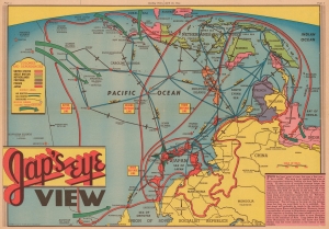
Jap's Eye View.
$400.00
Acquire
- Digital Map Information
- Suitable for large format printing
- Full resolution TIFF file
- ICC color profile embedded
- Delivered instantly via download link
This is a 1944 Edwin Sundberg map of East Asia, Southeast Asia, and the East Indies, published in the Sunday News in New York City. Sundberg chose to illustrate the region in the opposite orientation from what most of his American audience would have been accustomed to, providingSunday News readers with a new perspective ('the Japanese point of view) on the continued push across the Pacific toward Japan. (more details)
World War II in France in November 1944.
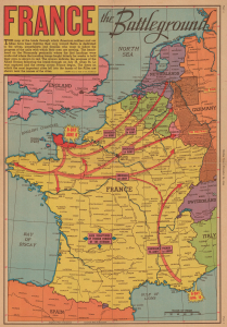
France the Battleground.
$375.00
Acquire
- Digital Map Information
- Suitable for large format printing
- Full resolution TIFF file
- ICC color profile embedded
- Delivered instantly via download link
This is a 1944 Edwin Sundberg map of France, illustrating the Allied progress since the successful D-Day landings in Normandy on June 6, 1944. The map provides an overview of the fighting in France during the autumn of 1944, noting the dates when major cities were liberated. (more details)
Published 4 months before the American invasion.
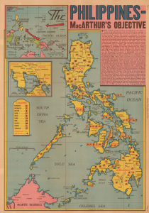
Philippines MacArthur's Objective.
$650.00
Acquire
- Digital Map Information
- Suitable for large format printing
- Full resolution TIFF file
- ICC color profile embedded
- Delivered instantly via download link
This is a June 1944 Edwin Sundberg map of the Philippines published by the Sunday News, published 4 months before the Allied invasion of the Philippines. The map offers an overview of the strategically important archipelago and provides a brief history of foreign involvement. (more details)
Predicting fighting in China days before the atomic bombing of Hiroshima.
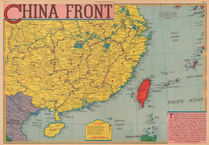
China Front.
$350.00
Acquire
- Digital Map Information
- Suitable for large format printing
- Full resolution TIFF file
- ICC color profile embedded
- Delivered instantly via download link
This is a 1945 Edwin Sundberg map of China marking American air bases. It predicts future military operations in the region near the end of World War II (1939 - 1945). Nonetheless, it appeared just 9 days before the atomic bomb was dropped on Hiroshima, Japan, and the end of the Pacific War. (more details)