
Sundberg, Edwin L. (sold)

Edwin L. Sundberg (1898 - 1978) was an American cartographer known for his pictorial pieces. Sundberg was a staff artist for the Sunday News in New York City and eventually became Chief Cartographer in charge of a small staff of artists.
Ilustrates the 'war situation' in East Asia just before the outbreak of WWII.
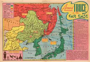
Armed Truce in the Far East.
sold
- Digital Map Information
- Suitable for large format printing
- File Size: 29.72 MB
- File Type: ZIP / TIFF
- ICC color profile embedded
- Delivered instantly via download link
This is a 1938 Edwin L. Sundberg pictorial map of East Asia. Tracing 'border incidents' between the Russians and the Japanese from 1935 until 1938, the map depicts the region from Ulaanbaatar to the Pacific Ocean and from the Soviet Union to Kyushu. (more details)
Highlights French champagne, wine, and cheese!
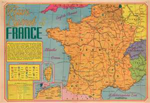
Fair Land of France.
sold
- Digital Map Information
- Suitable for large format printing
- File Size: 26.92 MB
- File Type: ZIP / TIFF
- ICC color profile embedded
- Delivered instantly via download link
This is a 1939 Edwin Sundberg map of France. Sundberg uses icons to mark regions where specific resources, including champagne, cheese, and wine, are cultivated, mined, or raised. France's major highways, and those of surrounding countries, are illustrated in red, and dashed lines mark international steamer routes. A text box along the left border discusses France's economic success, its population, and its geographic size. Insets, situated in the lower left quadrant, focus on Corsica and France's North African colonies, Morocco, Algeria, and Tunisia. A graph in the lower left corner compares France's imports and exports and differentiates them by country of export or import. (more details)
Published August 27, 1939, only days before Hitler's Germany invades Poland and begins World War II.
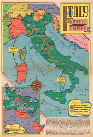
Italy - Newest Empire.
sold
- Digital Map Information
- Suitable for large format printing
- File Size: 26.01 MB
- File Type: ZIP / TIFF
- ICC color profile embedded
- Delivered instantly via download link
This is a 1939 Edwin Sundberg map of Italy published days before the outbreak of World War II. The map depicts the region from France to Yugoslavia and from Germany and Switzerland to Sicily and the Mediterranean Sea. Focusing on the development of Italy from a collection of principalities and duchies into a unified country, small yellow boxes with red font boldly declare when each area was incorporated into the whole. An inset map in the lower left corner highlights Italy's territorial gains outside its home peninsula, placing its colonial adventurism in Africa and its war gains in contrast with the Ancient Roman Empire, which served as Mussolini's inspiration. (more details)
Printed one month before the start of World War II, the Sunday News asks the question, 'War or Peace?'
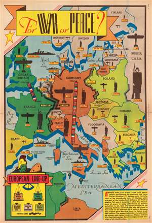
For War or Peace?
sold
- Digital Map Information
- Suitable for large format printing
- File Size: 32.72 MB
- File Type: ZIP / TIFF
- ICC color profile embedded
- Delivered instantly via download link
Published on Sunday, July 30, 1939, one month before Nazi Germany invades Poland and starts World War II, this Edwin Sundberg pictorial map of Europe compares the relative strength of European militaries while posing the question, 'For War or Peace'? Depicting Europe from Ireland and Spain to Russia and from Scandinavia to North Africa, Sundberg deftly uses color to illustrate the ever-building tensions between the 'Rome - Berlin Axis' and the 'London - Paris Alliance'. A ribbon of Nazi and Italian flags connects Berlin and Rome, while both Germany and Italy are shaded orange. A very similar ribbon of British and French flags connects London and Paris, with France and Great Britain colored green. French and Italian colonies are green and orange, respectively. Light shades of green and orange denote which countries are leaning toward the Alliance or the Axis, while nations colored gray are believed to be either neutral or undecided. Solid black lines along international borders denote fortifications. (more details)
Illustrates a hypothetical Pacific Ocean blockade of Japan - published nearly three years before the Japanese attack on Pearl Harbor.
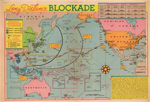
Long Distance Blockade.
sold
- Digital Map Information
- Suitable for large format printing
- File Size: 29.48 MB
- File Type: ZIP / TIFF
- ICC color profile embedded
- Delivered instantly via download link
This is a 1939 Edwin Sundberg pictorial map of a hypothetical Pacific Ocean blockade against Japan. The map depicts the region from central Asia to the Atlantic Ocean and from the Bering Sea to New Zealand. Originally published in 1937 by the New York Sunday News in connection with the Second Sino-Japanese War, then raging in Asia between China and Japan, the News elected to update the content and publish a second edition after the announcement of the Naval Expansion Act. (more details)
Invasion of Britain?
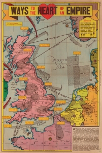
Ways to the Heart of the Empire.
sold
- Digital Map Information
- Suitable for large format printing
- Full resolution TIFF file
- ICC color profile embedded
- Delivered instantly via download link
This is a 1941 Edwin Sundberg pictorial map of Britain and northwestern Europe focusing on a potential Nazi invasion of Britain. (more details)
One year after Pearl Harbor.
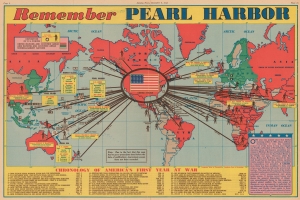
Remember Pearl Harbor.
sold
- Digital Map Information
- Suitable for large format printing
- Full resolution TIFF file
- ICC color profile embedded
- Delivered instantly via download link
This is Edwin Sundberg's December 6, 1942, map of the world summarizing the first year of the American involvement in World War II (1939 - 1945). (more details)
World War II as of mid-October 1943.
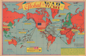
Global War.
sold
- Digital Map Information
- Suitable for large format printing
- Full resolution TIFF file
- ICC color profile embedded
- Delivered instantly via download link
This is a 1943 Edwin Sundberg pictorial map of the world illustrating the contemporaneous state of the ongoing World War II (1939 - 1945). Sundberg highlights the far-flung places where American soldiers are occupying, fighting, and dying, and expertly uses color to emphasize the major theaters of combat as of mid-October 1943. (more details)
Published on New Year's Eve in 1944.
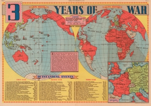
3 Years of War.
sold
- Digital Map Information
- Suitable for large format printing
- File Size: 25.07 MB
- File Type: ZIP / TIFF
- ICC color profile embedded
- Delivered instantly via download link
This is a 1944 Edwin Sundberg map of the world during World War II. Published on December 31, 1944, the map provides a visual summary of three years of American involvement in the global conflict. Allied nations are shaded red, while green codes parts of the world still occupied by Germany and Japan. It is worth noting that Leyte, an island in the Philippines that the Allies invaded in October 1944, is shaded red. A text box to the left of center over the South Pacific relates a summary of the three years following the Japanese attack on Pearl Harbor. The text uses that anniversary as a focal point and situates the war's events around that world-changing day. Sixty events from the preceding three years (twenty each) are numerically identified and correspond with an index along the bottom border. This numerical index includes a summary of each battle or event and the date it occurred. Among the noted actions are the Japanese attack on Pearl Harbor, the Battle of Midway, the conquest of Guadalcanal, the invasion of Italy, Italy's surrender, the D-Day landings in Normandy, and the liberation of Paris. An inset, situated in the lower right, focuses on the war in Western Europe and highlights Allied gains. (more details)
A colorful map of the Mississippi River System highlighting efforts at flood control following the devastating floods of 1945.
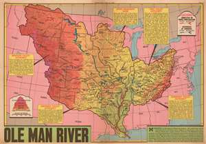
Ole Man River.
sold
- Digital Map Information
- Suitable for large format printing
- File Size: 21.55 MB
- File Type: ZIP / TIFF
- ICC color profile embedded
- Delivered instantly via download link
This is a 1945 Edwin L Sundberg map of the Mississippi River System in the United States. The map depicts the region from Nevada and Idaho to the Atlantic Ocean and from Canada to Texas and the Gulf of Mexico. After the region suffered one of its worst floods in recorded history, attention was focused on measures being taken to prevent such disasters. Red and blue notations on the map highlight levees and reservoirs used in flood control, with red levees and reservoirs representing projects that had been completed or were currently under construction and blue ones noting future projects that had already been approved by Congress. This vast undertaking not only prevented citizens from losing their homes to floodwaters, but also held numerous other benefits, such as 'power production, irrigation, navigation, and wildlife and soil conservation' in the Missouri Valley. Similar projects in the Arkansas Valley were meant to help with irrigation and dust control. Each reservoir, no matter whether it was completed or proposed, is identified by name. Shading is used to illustrate the changes in elevation throughout the system, which provides a much broader image for the reader. Text boxes about the Missouri Valley Authority, the Arkansas Valley Authority, the Tennessee Valley Authority, the Ohio Valley Authority, and the Upper Mississippi Basin contain information about each authority. (more details)
A colorful map of the Mississippi River System highlighting efforts at flood control following the devastating floods of 1945.
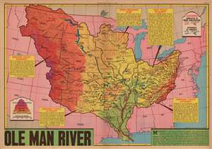
Ole Man River.
sold
- Digital Map Information
- Suitable for large format printing
- File Size: 76.44 MB
- File Type: ZIP / TIFF
- ICC color profile embedded
- Delivered instantly via download link
This is a 1945 Edwin L. Sundberg map of the Mississippi River System in the United States. After the region suffered one of its worst floods in recorded history, attention focused on measures being taken to prevent such disasters. Red and blue notations highlight levees and reservoirs used in flood control, with red levees and reservoirs representing projects that had been completed or were currently under construction and blue ones noting future projects that had already been approved by Congress. This vast undertaking not only prevented citizens from losing their homes to floodwaters, but also held numerous other benefits, such as 'power production, irrigation, navigation, and wildlife and soil conservation' in the Missouri Valley. Similar projects in the Arkansas Valley were meant to help with irrigation and dust control. Each reservoir, no matter whether it was completed or proposed, is identified by name. Shading is used to illustrate the changes in elevation throughout the system, which provides a much broader image for the reader. Text boxes about the Missouri Valley Authority, the Arkansas Valley Authority, the Tennessee Valley Authority, the Ohio Valley Authority, and the Upper Mississippi Basin contain information about each authority. (more details)
2.5 years before the creation of Israel by the United Nations.
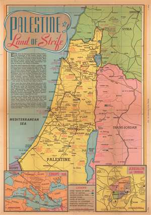
Palestine Land of Strife.
sold
- Digital Map Information
- Suitable for large format printing
- File Size: 18.83 MB
- File Type: ZIP / TIFF
- ICC color profile embedded
- Delivered instantly via download link
This is a 1945 Edwin Sundberg map of Palestine. The map depicts the region from Sidon to the Dead Sea and from the Mediterranean to Damascus. Throughout the region, cities and towns are labeled, and modern highways connect many of the major population centers. Red text marks important locations in Biblical history and battles fought in the region during the Crusades and World War I. Crosses mark cities visited by Jesus. An inset in the lower right corner details Jerusalem and its environs, including the divisions of the Old City. A second inset on the lower left illustrates Europe in 1938, the year before Adolf Hitler and Nazi Germany invaded Poland and ignited World War II. (more details)
Will there be a 4th?
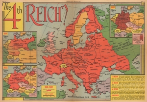
The 4th Reich?
sold
- Digital Map Information
- Suitable for large format printing
- Full resolution TIFF file
- ICC color profile embedded
- Delivered instantly via download link
This is a March 1947 Edwin Sundberg map of Europe and German Empires published by the Sunday News. The map questions whether a fourth Germanic empire might one day arise from the ashes of the Third Reich. (more details)
Highlights Yellowstone, Yosemite, and Grand Canyon National Park among numerous others.
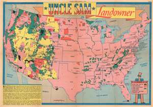
Uncle Sam Landowner.
sold
- Digital Map Information
- Suitable for large format printing
- File Size: 23.4 MB
- File Type: ZIP / TIFF
- ICC color profile embedded
- Delivered instantly via download link
This is a 1949 Edwin Sundberg map of the United States marking national parks, forests, monuments, and Indian reservations. The map depicts the continental United States from the Pacific Ocean to the Atlantic Ocean and from Canada to Mexico and the Gulf of Mexico. With the U.S. shaded in pink, the federal lands, highlighted in various different colors, are clearly apparent. National parks, including Yellowstone, Acadia, Grand Canyon, Sequoia, and Yosemite, are shaded black, giving them the most prominent place visually. Red areas are Indian reservations. The green areas are, naturally, national forests, while the orange areas denote national wildlife refuges and the yellow grazing districts. All of the states are labeled, and the national parks are prominently identified by block lettering. Smaller block lettering labels national monuments, while national forests, grazing districts, and Indian reservations remain unidentified by name. The only city referenced, even indirectly, is Washington, D.C. since the District is outlined. The stars that dot the U.S. from coast to coast denote 'military and naval areas'. A legend, held by a caricature of Uncle Sam, is situated in the lower right corner. (more details)
Charitable Imperialism.
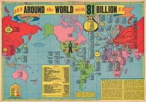
Around the World with 81 Billion.
sold
- Digital Map Information
- Suitable for large format printing
- File Size: 25.23 MB
- File Type: ZIP / TIFF
- ICC color profile embedded
- Delivered instantly via download link
This is a 1950 Edwin Sundberg map of the world highlighting U.S.-financed foreign aid in the wake of World War II. The map both lauds American generosity and suggests potential concerns that the funds might be misused or simply not paid back. (more details)