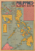
1944 Sundberg Map of the Philippines
Philippines-sundberg-1944$650.00


Title
Philippines MacArthur's Objective.
1944 (dated) 20.75 x 14.5 in (52.705 x 36.83 cm) 1 : 3000000
1944 (dated) 20.75 x 14.5 in (52.705 x 36.83 cm) 1 : 3000000
Description
This is a June 1944 Edwin Sundberg map of the Philippines published by the Sunday News, published 4 months before the Allied invasion of the Philippines. The map offers an overview of the strategically important archipelago and provides a brief history of foreign involvement.
A Closer Look
The central map depicts the Philippines from the Babuyan Islands south to Borneo and the Celebes Sea. Luzon, Leyte, Samar, Panay, Mindoro, Negros, Mindanao, and Palawan are identified. Railroad lines on Luzon, Negros, Panay, and Cebu are illustrated. Red stars mark air bases. Icons provide an overview of the archipelago's rich resources, including gold, corn, silver, rice, sugar, and tobacco. An inset in the upper left corner situates the Philippines in relation to other islands in the Southwest and Central Pacific, many of which readers of the Sunday News would have recognized, such as the Solomon Islands, New Guinea, the Marshall Islands, and the Caroline Islands. Large red arrows illustrate forces under General MacArthur from New Guinea and forces under Admiral Nimitz from the Marshall Islands converging on the Philippines. A second inset depicts Manila Bay and its environs.The Philippine Campaign
Launched on October 20, 1944, with an invasion of Leyte, the Philippine Campaign was a World War II joint American, Australian, and Filipino military operation intended to liberate the Philippine Islands from occupying Imperial Japanese forces. The Japanese Army overran most of the Philippines during the first half of 1942, retaining it for the subsequent 2 years. American General Douglas MacArthur began the campaign by announcing on Philippine radio 'This is the Voice of Freedom, General MacArthur speaking. People of the Philippines: I have returned.' The campaign progressed rapidly, driving the Japanese out of one island after another. Although by this time, the Japanese were clearly losing the war, they gave no sign of capitulation and refused to surrender. During the campaign, Japan suffered nearly half a million casualties compared to only about 50,000 Americans. The campaign continued until Japanese forces in the Philippines were ordered to surrender by Tokyo on August 15, 1945, after the dropping of atomic bombs on Hiroshima and Nagasaki.Publication History and Census
This map was created by Edwin Sundberg and published by the Sunday News in New York City on June 11, 1944. This is the only recorded surviving example.Cartographer
Edwin L. Sundberg (1898 - 1978) was an American cartographer known for his pictorial pieces. Sundberg was a staff artist for the Sunday News in New York City and eventually became Chief Cartographer in charge of a small staff of artists. More by this mapmaker...
Source
Sunday News, June 11, 1944.
Condition
Very good. Light wear along original fold lines. Closed edge tears professionally repaired on verso.