
Van Loon, Harmanus

Harmanus van Loon (fl. c. 1690 - c. 1725) was a Flemish engraver active in Paris during the late 17th and early 18th centuries. Van Loon worked primarily in Paris and often signed his work, which includes maps and other engravings for such prominent cartographers as Nicolas de Fer, Jean Baptiste Nolin, Guillaume Delisle, and others. There is some speculation that he may have been related to the Brussels born painter Theodorus van Loon.
Rare Early State of an Elegant, French Map of the Western Hemisphere

L'Amerique, meridionale, et septentrionale Dressée selon les Dernieres Relations et suivant les Nouvelles Decouvertes dont les pounts prin= cipaux sont placez sur les Observations de Mrs. de l'Academie Royale des Sciences.
$2,500.00
Acquire
- Digital Map Information
- Suitable for large format printing
- Full resolution TIFF file
- ICC color profile embedded
- Delivered instantly via download link
This is Nicolas de Fer's 1699 map of America, in a lovely old color example of the second state, printed in 1705. Both of the first two states of this map were separately issued, and are consequently rare. This detailed and richly annotated map, derived from De Fer's own 1698 L'Amerique Divisée Selon Letendue de set Principales Parties, shows the Americas during a period in which France was dominant in the exploration and mapping of North America. Its superb engraving is the work of Harmanus Van Loon, who also engraved De Fer's larger-scale work. (more details)
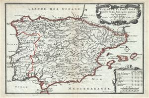
Espagne et Portugal Divises en ses Princiaples parties ou Royaumes.
$350.00
Acquire
- Digital Map Information
- Suitable for large format printing
- Full resolution TIFF file
- ICC color profile embedded
- Delivered instantly via download link
This is a beautiful 1701 map of Spain and Portugal by Nicholas De Fer. It covers the Iberian Peninsula as well as adjacent parts of France and Africa and prominently displays the Balearic Islands of Majorca, Minorca, and Ibiza. The map renders the entire region in ... (more details)
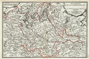
Les Estats du Duche de Milan.
$300.00
Acquire
- Digital Map Information
- Suitable for large format printing
- Full resolution TIFF file
- ICC color profile embedded
- Delivered instantly via download link
This is a scarce 1701 map of the Duchy of Milan in Northern Italy by Nicholas De Fer. Centered on the city of Milan, it covers the northern part of Italy from Lake Como south to Bobbio and from Turin east as far as Lake Garda. Includes parts of the regions of ... (more details)