
Wall, Walter Eugene

Walter Eugene Wall (October 13, 1867 - July 23, 1944) was an American surveyor. Born in Yreka, California, he arrived in Honolulu with his parents in 1880. His father was the architect in charge of the construction of the Iolani Palace. He began working at the Hawaiian Government Survey in 1889 and was appointed Territorial Surveyor General in 1901. He worked for the survey for more than 35 years. Wall attended the Ponahou School where he was known for his athletics, introducing the curveball (referenced as 'curve pitching in baseball' in his obituary) to Hawaii. He married Edith Louise Dietz on June 22, 1903. He died in 1944 in Honolulu.
Lanai's traditional Hawaiian land subdivisions.
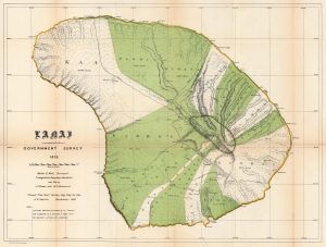
Lanai.
$850.00
Acquire
- Digital Map Information
- Suitable for large format printing
- File Size: 56.56 MB
- File Type: ZIP / TIFF
- ICC color profile embedded
- Delivered instantly via download link
This is the 1878 / 1906 Hawaiian Government Survey and Hawaiian Territorial Survey map of Lanai, Hawaiian Islands. Jacob Brown and Marcus Monsarrat produced this detailed survey of Lanai in 1878, publishing at that time the preliminary version of the present map, the first to correctly capture Lanai's form. Today Lanai is the smallest publicly accessible inhabited island. Here, Lanai's ahupua'a, traditional land subdivisions, stretch across the island. The few roads are illustrated, along with a handful of foot trails. (more details)
First map of Niihau from a scientific survey.
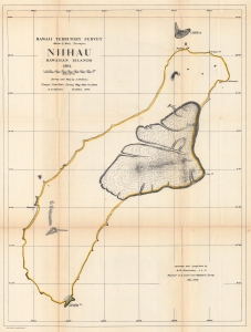
Hawaii Territorial Survey. Niihau Hawaiian Islands.
$350.00
Acquire
- Digital Map Information
- Suitable for large format printing
- File Size: 42.62 MB
- File Type: ZIP / TIFF
- ICC color profile embedded
- Delivered instantly via download link
The most accurate map of the island up to that time, this is the 1906 Kerns and Newton map of Niihau, Hawaiian Islands. The map is based on the 1903 Samuel M. Kerns survey, consigned to print in 1906 by Herbert E. Newton. It marks points, bays, and other coastal features. The lava fields around Puulua, Kaleo, and Paniau are illustrated. The elevation of Kawaihoa Point, on the southern tip of the island, is provided as well. (more details)