1906 Kerns and Newton Map of Niihau, Hawaiian Islands
Niihau-kernsnewton-1906$350.00

Title
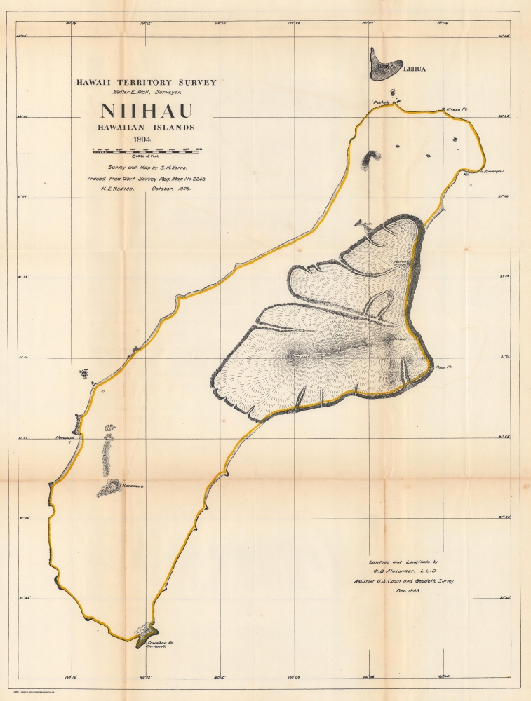
Hawaii Territorial Survey. Niihau Hawaiian Islands.
1906 (dated) 25.75 x 19.25 in (65.405 x 48.895 cm) 1 : 48000
1906 (dated) 25.75 x 19.25 in (65.405 x 48.895 cm) 1 : 48000
Description
The most accurate map of the island up to that time, this is the 1906 Kerns and Newton map of Niihau, Hawaiian Islands. The map is based on the 1903 Samuel M. Kerns survey, consigned to print in 1906 by Herbert E. Newton. It marks points, bays, and other coastal features. The lava fields around Puulua, Kaleo, and Paniau are illustrated. The elevation of Kawaihoa Point, on the southern tip of the island, is provided as well.
Publication History and Census
This map was created by Samuel M. Kerns with longitude and latitude added by William DeWitt Alexander in 1903 and traced from Kerns' original by Herbert E. Newton in 1906 for publication in Annual Reports of the Department of the Interior for the Fiscal Year Ended June 30, 1906. We note five examples cataloged in OCLC: Michigan State University, Brigham Young University, the University of California San Diego, the University of California Davis, and the University of Hawai'i at Hilo; as well as an example in the David Rumsey Map Collection.CartographerS
Samuel M. Kerns (18xx - 19xx) was one of three surveyors working for the U.S. Coast and Geodetic Survey who triangulated the position of Niihau relative to Kauai in 1903. He also completely surveyed Niihau by triangulation, the first such survey conducted and the only correct survey of the island up to that time. The previous survey of the island had been conducted thirty years prior. He also played a critical role in improving the street of Honolulu in the early 1900s. More by this mapmaker...
Herbert Ellsworth Newton (September 2, 1882 - January 30, 1963) was a Hawaiian surveyor and engineer. Born in Maui County, Hawaii, Newton attended school in the islands before joining the Hawaiian Territorial Survey as a 'rodman' in November 1900. (Rodmen transport and set up survey equipment and prepare the job site.) He worked for the Hawaiian Territorial Survey for nearly 50 years and was the chief cadastral engineer when he retired on July 1, 1950, at the time the longest continual service with the Hawaii Territorial government. He made the first official map of the Hawaii Territory in 1919. He married Minnie Hutchison in June 1906, and they had three children. Learn More...
William DeWitt Alexander (1833 - 1913) was a Hawaiian born historian, publisher, writer, surveyor, and teacher. Alexander was born in Honolulu in 1833 to missionary parents. He received a degree from Yale University in 1855. After completing his studies, Alexander remained in the continental United States, first, during the winter of 1855 - 56, taking a job at Beloit College in Wisconsin. Then he moved on to become the schoolmaster of the Vincennes Academy in Vincennes, Indiana, a school recently started by one of his uncles. He returned to Hawaii in 1858 after receiving an offer to teach at the Punahou School, where he taught Greek and history. He became president of the school (then known as O'ahu College) in November 1864. During this time Alexander published a number of books on Hawaiian history and ethnography. In 1869, during a summer vacation, Alexander undertook a survey and produced a map of the Haleakala Crater on Maui. Although he had spent the previous fourteen years in education, he came by his surveying skills honestly. His father, William Patterson Alexander, was a surveyor, and 'W. D.' (as Alexander was known during his childhood) would likely help his father when on vacation from attending the Punahou School. Alexander's map of Haleakala was likely the most scientific land survey of Hawaii produced up to that time. With this achievement, Alexander was appointed surveyor general of the Hawaiian Government Survey in the fall of 1870. This appointment handed Alexander the task of creating a surveying and mapping agency for the Hawaiian government. In this office Alexander did much of his most important work in mapping the Hawaiian Islands. He remained the Surveyor-General of the Hawaiian Government Survey until American annexation of the Hawaiian Islands in 1898, and even then, because the transition took place over a few years, he held the position until 1901. Eventually he attained the office of Surveyor-General of the Territory of Hawaii and a high position in the Privy Council of Kalakaua and Lili'uokalani. Alexander resigned as the head of the Hawaiian Territorial Survey in 1901 when he was put in charge of the Branch Office of the U.S. Coast and Geodetic Survey in the Hawaiian Islands. Alexander married Abigail Charlotte Baldwin in 1860 with whom he had three sons and two daughters. Learn More...
Walter Eugene Wall (October 13, 1867 - July 23, 1944) was an American surveyor. Born in Yreka, California, he arrived in Honolulu with his parents in 1880. His father was the architect in charge of the construction of the Iolani Palace. He began working at the Hawaiian Government Survey in 1889 and was appointed Territorial Surveyor General in 1901. He worked for the survey for more than 35 years. Wall attended the Ponahou School where he was known for his athletics, introducing the curveball (referenced as 'curve pitching in baseball' in his obituary) to Hawaii. He married Edith Louise Dietz on June 22, 1903. He died in 1944 in Honolulu. Learn More...
Andrew B. Graham (1845 - September 9, 1909) was an American lithographer active in Washington, D.C. in late 19th and early 20th century. Graham was born in Washington D.C., the son of a lithographer and engraver. After college, he joined the U.S. Coast Survey, where he was a draftsman until 1889. He retired from the Coast Survey to take over management of his father's lithography firm. The firm, Andrew B. Graham Company, was one of several that thrived on lucrative government publication contracts. Graham died of 'brain fever' in his Washington D. C. residence on September 9 of 1909. Some of his work was republished posthumously until about 1917, and his firm was active until at least the early 1920s. Learn More...
Source
Governor of Hawaii Board of Indian Commissioners, 'Report of the Governor of Hawaii', Annual Reports of the Department of the Interior for the Fiscal Year Ended June 30, 1906, (Washington: Government Printing Office) 1907.
Condition
Very good. Light wear and toning along original fold lines. Slight soiling along original fold lines. Slight loss at two fold intersections.
References
Rumsey 3705.008. OCLC 145505013.