
Yardley, Richard Quincy
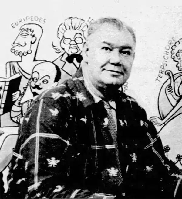
Richard Quincy Yardley (March 11, 1903 - November 24, 1979), known euphemistically as 'Moco,' was an American cartoonist based in Baltimore. Yardley worked as a cartoonist for the Baltimore Sun from 1923. In 1949 he became the editorial cartoonist for the Baltimore Sun, a position he held for roughly 20 years. He also produced cartoons for The Saturday Evening Post, The New Yorker and the Reporter. His syndicated daily comic, Our Ancestors, was published from 1961 to 1965. His work exhibited a humorous satirical style drawing on local personalities and historical events. One writer, Charles Bissell, described his work thus,
His style, which might be described as early Ming, middle comic strip, late Picasso, and all Yardley—or perhaps better some other way-is not suitable for editorial cartoons. To begin with, it's not serious. We all know how you've got to be mighty serious about lots of things-atom bombs, for instance. You couldn't put over something big and profound by drawing a couple of nudeniks with four heads, a little banjo-eyed character in a beret and maybe a cat, all caught up in some sort of symbolical astral soup and expect to scare daylights out of your readers. Well, no, you couldn't—but Yardley can. (AAEC News, April 1964)He issued several satirical cartoon maps, including a map of Herr Hitler's Heaven, Johns Hopkins Hospital, Anne Arundel County, Baltimore County, and Annapolis. Yardley was a member of the National Cartoonists Society, the American Association of Editorial Cartoonists and the National Press Club. He retired in 1972.
Comic yet honest pictorial map of Baltimore County.
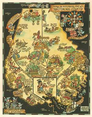
Being Ye Historical Map of Baltimore County.
$750.00
Acquire
- Digital Map Information
- Suitable for large format printing
- Full resolution TIFF file
- ICC color profile embedded
- Delivered instantly via download link
This is a c. 1935 Richard Yardley pictorial map of Baltimore County, Maryland. Populated by comical caricatures of the county's residents, Yardley both mocks and celebrates its history. Many of these vignettes illustrate historical events, such as the county's founding, its involvement in the American Revolution, the War of 1812, and the American Civil War. Baltimore itself does not appear on the map since it was separated from the county in 1851. Yardley acknowledges the role Native Americans played, stating that many of the modern-day county roads started as Indian trails. The other side of the coin was that Fort Garrison, near Pikesville, was built as a defense against those same Indians. Joppa occupies a sizable portion of the map, with its bustling trade with England and the West Indies prominently touted. A banner also states that the city was the county seat in 1712. (more details)
Comic yet honest pictorial map of Baltimore County.
Being Ye Historical Map of Baltimore County.
$500.00
Acquire
- Digital Map Information
- Suitable for large format printing
- Full resolution TIFF file
- ICC color profile embedded
- Delivered instantly via download link
This is a c. 1935 Richard Yardley pictorial map of Baltimore County, Maryland, presented here in an unusual two-tone printing. Populated by comical caricatures of the county's residents, Yardley both mocks and celebrates Baltimore history. (more details)
One of the founding institutions of modern American medicine.
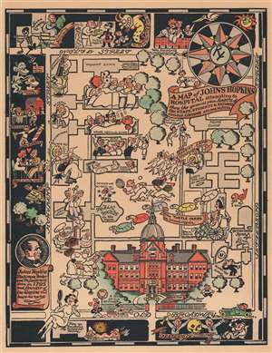
A Map of Johns Hopkins Hospital attempting to show the general plan, HABITS of the STAFF, STUDENTS, and PATIENTS, curious CUSTOMS etc. and so forth.
$750.00
Acquire
- Digital Map Information
- Suitable for large format printing
- File Size: 8.66 MB
- File Type: ZIP / TIFF
- ICC color profile embedded
- Delivered instantly via download link
This is a 1935 Richard Q. Yardley pictorial map of Johns Hopkins Hospital in Baltimore, Maryland. A fantastic illustration of the original Administration Building occupies the lower portion of the map and immediately draws the eye. From there, the hospital's various wards, clinics, and buildings are illustrated. Many of the illustrations are comical in nature. A researcher standing atop a large microscope is mocked by a germ in the General Pathology Department, while a researcher stares at question marks under a microscope in the research lab. Three nurses are shocked by a patient's temperature in the Osler Medical Clinic and a 'patient on the mend' watches the annual Turtle Derby. (The Turtle Derby was still an annual event as of 2015. It began in 1931 as a way to entertain the children at the Children's Clinic.) A surgeon to the right of the Administration Building attempts to operate on a shocked patient with a large knife. A pictorial border surrounds the hospital's campus on three sides and identifies local hangouts, shops, and other buildings related to the university, including Welch Library and Fraternity Row. 'A studious young gentleman' sits atop a pile of books near Welch Library, while a young couple awaiting a baby brought by a stork marks housing for married interns. (more details)
One of the founding institutions of modern American medicine.
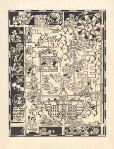
A Map of Johns Hopkins Hospital attempting to show the general plan, HABITS of the STAFF, STUDENTS, and PATIENTS, curious CUSTOMS etc. and so forth.
$750.00
Acquire
- Digital Map Information
- Suitable for large format printing
- Full resolution TIFF file
- ICC color profile embedded
- Delivered instantly via download link
This is a c. 1935 Richard Q. Yardley pictorial map of Johns Hopkins Hospital in Baltimore, Maryland. The hospital and its associated medical school were the progenitors of the modern American medical education system, and the hospital has long been considered among the best in the world. (more details)
Delmarva Peninsula (Chesapeake Bay).
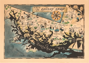
A Map of the Eastern Shore … Rich in History, Romance and (yum) Seafood.
$975.00
Acquire
- Digital Map Information
- Suitable for large format printing
- File Size: 52.49 MB
- File Type: ZIP / TIFF
- ICC color profile embedded
- Delivered instantly via download link
This is Richard Q. Yardley's charming map of the eastern shore of the Chesapeake Bay. It is an iconic representation of a region steeped in local and historical character. (more details)