This item has been sold, but you can get on the Waitlist to be notified if another example becomes available, or purchase a digital scan.
1940 Richard Q. Yardley Pictorial Map of Annapolis, Maryland
Annapolis-yardley-1940$200.00

Title
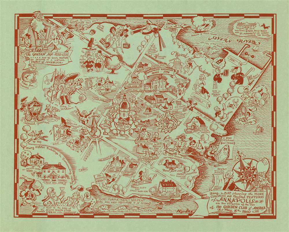
Being a MAP showing the MORE COLONIAL and Nautical FEATURES of ANNAPOLIS on the Occasion of the visit of the GARDEN CLUB of AMERICA.
1940 (dated) 15.5 x 19.5 in (39.37 x 49.53 cm)
1940 (dated) 15.5 x 19.5 in (39.37 x 49.53 cm)
Description
A charming Richard Q. Yardley pictorial map of Annapolis, Maryland issued in 1940 by the Garden Club of America to commemorate their visit to said city. Printed with striking red ink on blue-green paper, this mapis oriented generally to the north. The map is centered on the State house, constructed in 1772, with the United States Naval Academy occupying the upper right quadrant. Local characters, historical buildings, and historian annotations appear throughout in Yardley's inimitable style.
The Garden Club of America
The Garden Club of America (GCA) was founded in 1913 to support advancement in horticulture, natural conservation, and civic improvements. The garden club was initially formed by consolidating twelve smaller garden clubs into a national organization under Helena Rutherfurd Ely (1858-1920) and Henrietta Marion Grew Crosby (1872-1957). Early on, the club focused on recording and documenting great American gardens that were either scheduled to be destroyed or which had fallen into repair. Members traveled throughout the United States, photographing and documenting these gardens. Today, the Garden Club work with national and city parks to preserve historical gardens and natural wonders.Publication History and Census
This map was commissioned by the Garden Club of America to commemorate its May 9, 1940 visit to Annapolis. It was drawn by Richard Quincy Yardley. It is one of his scarcer maps, as it never had mass production and was only distributed among Garden Club members who attended the meeting. We are aware of only one other example located at the Hagley Museum and Library, Wilmington, Delaware.Cartographer
Richard Quincy Yardley (March 11, 1903 - November 24, 1979), known euphemistically as 'Moco,' was an American cartoonist based in Baltimore. Yardley worked as a cartoonist for the Baltimore Sun from 1923. In 1949 he became the editorial cartoonist for the Baltimore Sun, a position he held for roughly 20 years. He also produced cartoons for The Saturday Evening Post, The New Yorker and the Reporter. His syndicated daily comic, Our Ancestors, was published from 1961 to 1965. His work exhibited a humorous satirical style drawing on local personalities and historical events. One writer, Charles Bissell, described his work thus,
His style, which might be described as early Ming, middle comic strip, late Picasso, and all Yardley—or perhaps better some other way-is not suitable for editorial cartoons. To begin with, it's not serious. We all know how you've got to be mighty serious about lots of things-atom bombs, for instance. You couldn't put over something big and profound by drawing a couple of nudeniks with four heads, a little banjo-eyed character in a beret and maybe a cat, all caught up in some sort of symbolical astral soup and expect to scare daylights out of your readers. Well, no, you couldn't—but Yardley can. (AAEC News, April 1964)He issued several satirical cartoon maps, including a map of Herr Hitler's Heaven, Johns Hopkins Hospital, Anne Arundel County, Baltimore County, and Annapolis. Yardley was a member of the National Cartoonists Society, the American Association of Editorial Cartoonists and the National Press Club. He retired in 1972. More by this mapmaker...
Condition
Very good.
References
OCLC 84645785.