

Indiana.
sold
- Digital Map Information
- Suitable for large format printing
- File Size: 8.52 MB
- File Type: ZIP / TIFF
- ICC color profile embedded
- Delivered instantly via download link
A beautiful 1855 first edition example of Colton's map of Indiana. Covers Indiana in full as well as parts of adjacent states. Like most of Colton's state maps, this map is largely derived from an earlier wall map of North America produced by Colton and D. ... (more details)

Michigan.
sold
- Digital Map Information
- Suitable for large format printing
- File Size: 8.17 MB
- File Type: ZIP / TIFF
- ICC color profile embedded
- Delivered instantly via download link
A beautiful 1855 first edition example of Colton's map of Michigan. Covers lower part of the state bounded by Lake Michigan on the west and Lake Huron on the east. Like most of Colton's state maps, this map is largely derived from an earlier wall map of ... (more details)

Arkansas.
sold
- Digital Map Information
- Suitable for large format printing
- File Size: 7.76 MB
- File Type: ZIP / TIFF
- ICC color profile embedded
- Delivered instantly via download link
A beautiful 1855 first edition example of Colton's map of Arkansas. Covers the state in full as well as parts of the adjacent states. Like most of Colton's state maps, this map is largely derived from an earlier wall map of North America produced by ... (more details)

Kentucky and Tennessee.
sold
- Digital Map Information
- Suitable for large format printing
- File Size: 8.66 MB
- File Type: ZIP / TIFF
- ICC color profile embedded
- Delivered instantly via download link
A beautiful 1855 first edition example of Colton's map of Kentucky and Tennessee. Covers both states in full as well as parts of the adjacent states. Like most of Colton's state maps, this map is largely derived from an earlier wall map of North ... (more details)

Ohio.
sold
- Digital Map Information
- Suitable for large format printing
- File Size: 8.37 MB
- File Type: ZIP / TIFF
- ICC color profile embedded
- Delivered instantly via download link
A beautiful 1855 first edition example of Colton's map of Ohio. Covers the entire state as well as parts of the adjacent states. Like most of Colton's state maps, this map is largely derived from an earlier wall map of North America produced by ... (more details)
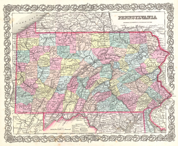
Pennsylvania.
sold
- Digital Map Information
- Suitable for large format printing
- File Size: 8.79 MB
- File Type: ZIP / TIFF
- ICC color profile embedded
- Delivered instantly via download link
A beautiful 1855 first edition example of Colton's map of Pennsylvania. Covers the entire state as well as parts of the adjacent states. Like most of Colton's state maps, this map is largely derived from an earlier wall map of North America ... (more details)

Delaware and Maryland.
sold
- Digital Map Information
- Suitable for large format printing
- File Size: 7.79 MB
- File Type: ZIP / TIFF
- ICC color profile embedded
- Delivered instantly via download link
A beautiful 1855 first edition example of Colton's map of Delaware. Covers both Delaware and Maryland as well as parts of the adjacent states. Like most of Colton's state maps, this map is largely derived from an earlier wall map of North ... (more details)

Connecticut with portions of New York and Rhode Island.
sold
- Digital Map Information
- Suitable for large format printing
- File Size: 8.86 MB
- File Type: ZIP / TIFF
- ICC color profile embedded
- Delivered instantly via download link
A beautiful 1855 first edition example of Colton's map of Connecticut and Long Island. Covers the entire state as well as the whole of Long Island, New York, Block Island, and the Long Island Sound. Like most of Colton's state maps, this ... (more details)

New York.
sold
- Digital Map Information
- Suitable for large format printing
- File Size: 9.05 MB
- File Type: ZIP / TIFF
- ICC color profile embedded
- Delivered instantly via download link
A beautiful 1855 first edition example of Colton's map of New York. Covers the entire state as well as adjacent parts of the adjacent states. Like most of Colton's state maps, this map is largely derived from an earlier wall map of North ... (more details)

Missouri.
sold
- Digital Map Information
- Suitable for large format printing
- File Size: 7.43 MB
- File Type: ZIP / TIFF
- ICC color profile embedded
- Delivered instantly via download link
A beautiful 1855 first edition example of Colton's map of Missouri. Covers the entire state as well as adjacent parts of Illinois and Kansas. Like most of Colton's state maps, this map is largely derived from an earlier wall map of North ... (more details)

Iowa.
sold
- Digital Map Information
- Suitable for large format printing
- File Size: 7.25 MB
- File Type: ZIP / TIFF
- ICC color profile embedded
- Delivered instantly via download link
A beautiful 1855 first edition example of Colton's map of Iowa. Covers the entire state as well as adjacent parts of Nebraska, Missouri, Minnesota, Wisconsin and Illinois. Like most of Colton's state maps, this map is largely derived ... (more details)

Wisconsin.
sold
- Digital Map Information
- Suitable for large format printing
- File Size: 7.53 MB
- File Type: ZIP / TIFF
- ICC color profile embedded
- Delivered instantly via download link
A beautiful 1855 first edition example of Colton's map of Wisconsin. Covers the entire state as well as adjacent parts of Minnesota and upper Michigan. Like most of Colton's state maps, this map is largely derived from an earlier ... (more details)

Maine.
sold
- Digital Map Information
- Suitable for large format printing
- File Size: 8.31 MB
- File Type: ZIP / TIFF
- ICC color profile embedded
- Delivered instantly via download link
A beautiful 1855 first edition example of Colton's map of Maine. Covers the entire state as well as adjacent parts of Canada. Like most of Colton's state maps, this map is largely derived from an earlier wall map of North America ... (more details)
First edition of Johnson's important Australia series.

Johnson's Australia.
sold
- Digital Map Information
- Suitable for large format printing
- File Size: 6.97 MB
- File Type: ZIP / TIFF
- ICC color profile embedded
- Delivered instantly via download link
A beautiful first edition example of A. J. Johnson's 1861 map of Australia. This is the first edition and earliest state in the Johnson Australia series. Depicts the continent with good detail along the coast and a largely ... (more details)

Vermont.
sold
- Digital Map Information
- Suitable for large format printing
- File Size: 7.62 MB
- File Type: ZIP / TIFF
- ICC color profile embedded
- Delivered instantly via download link
A beautiful 1855 first edition example of Colton's map of Vermont. Covers the entire state as well as adjacent parts of New Hampshire, New York, and Canada. Like most of Colton's state maps, this map is largely derived ... (more details)
Rare large format map of Nantucket Island.

No. 12 From Monomoy and Nantucket Shoals to Muskeget Channel Mass.
sold
- Digital Map Information
- Suitable for large format printing
- File Size: 22.33 MB
- File Type: ZIP / TIFF
- ICC color profile embedded
- Delivered instantly via download link
A scarce and exceptional example of the U.S. Coast Survey chart or map of Nantucket. The is the eastern sheet of a three map set - and is rarely offered separately. The this map (no. 12 in the series) covers the island of ... (more details)

Georgia.
sold
- Digital Map Information
- Suitable for large format printing
- File Size: 8.26 MB
- File Type: ZIP / TIFF
- ICC color profile embedded
- Delivered instantly via download link
A beautiful 1855 first edition example of Colton's map of Georgia. Covers the entire state as well as adjacent parts of Florida and Alabama. Like most of Colton's state maps, this map is largely derived from an earlier ... (more details)

Florida.
sold
- Digital Map Information
- Suitable for large format printing
- File Size: 6.41 MB
- File Type: ZIP / TIFF
- ICC color profile embedded
- Delivered instantly via download link
A beautiful 1855 first edition example of Colton's map of Florida. Like most of Colton's state maps, this map is largely derived from an earlier wall map of North America produced by Colton and D. Griffing Johnson. In ... (more details)

Alabama.
sold
- Digital Map Information
- Suitable for large format printing
- File Size: 8.05 MB
- File Type: ZIP / TIFF
- ICC color profile embedded
- Delivered instantly via download link
A beautiful 1855 first edition example of Colton's map of Mississippi. Covers the entire state as well as adjacent parts of Georgia and Mississippi. Like most of Colton's state maps, this map is largely derived from ... (more details)

Mississippi.
sold
- Digital Map Information
- Suitable for large format printing
- File Size: 8.67 MB
- File Type: ZIP / TIFF
- ICC color profile embedded
- Delivered instantly via download link
A beautiful 1855 first edition example of Colton's map of Mississippi. Covers the entire state as well as adjacent parts of Louisiana and Alabama. Like most of Colton's state maps, this map is largely derived from ... (more details)