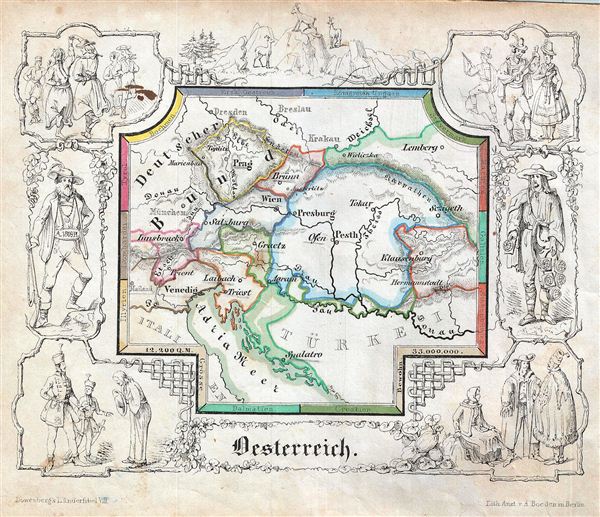
1846 Lowenberg Whimsical Map of Austria
Austria-lowenberg-1846$150.00

Title
Oesterreiche.
1846 (undated) 5.5 x 6.5 in (13.97 x 16.51 cm)
1846 (undated) 5.5 x 6.5 in (13.97 x 16.51 cm)
Description
A delightfully whimsical 1846 map of Austria, from a German kinderatlas or children's atlas. The map details the Austrian Empire at its peak and covers from Lemberg (Lviv) to Dalmatia with divisions shown by color coding. The whole is surrounded by a wide border featuring charming vignettes meant to illustrate the peoples and cultures of the region. The border of the map itself names the constituent lands of the Austrian Empire. The border illustrations include couples dancing, a man serenading a woman, portraits of two men on either side of the map, goats, a man bowing to two men in uniform, etc. The map is accompanied by its adjacent page, which includes a poetic history of the Austrian Empire in German gothic type. The wonderful and rare map was drawn by Anst. V A. Boeden of Berlin for inclusion as plate no. IX in the 1846 issue of Julius Loewenberg's Geographische Landerfibel.
Cartographer
Julius Loewenberg (1800 - December 12, 1893) was a German Jewish printer, geographer, and author active in Berlin during the middle part of the 19th century. Loewenberg was born in the Duchy of Posen. He attended Yeshiva in Kleczewo (Poland) and graduated to the Protestant Gymnasium of Thorn before moving on to study Christian theology and geography at the Universtiy of Berlin. His works include various atlases, histories, and several translations of the works of Alexander von Humboldt, with whom he was apparently close. Loewenberg died in a Jewish retirement home in Berlin. More by this mapmaker...
Source
Lowenberg, J., Geographische Landerfibel, (Berlin: Stern & C.) 1846.
Condition
Very good. Even overall toning. Blank on verso. Minor stain on top left illustration.