This item has been sold, but you can get on the Waitlist to be notified if another example becomes available, or purchase a digital scan.
1763 Buache Map of the Antarctic Continent or South Pole
Antarctica-gentlemansmagazine-1763$275.00

Title
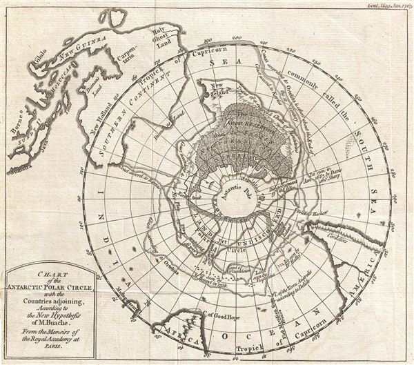
Chart of the Antarctic Polar Circle, with the Countries Adjoining, According to the New Hypothesis of M. Buache. From the Memoirs of the Royal Academy at Paris.
1763 (dated) 8 x 9 in (20.32 x 22.86 cm)
1763 (dated) 8 x 9 in (20.32 x 22.86 cm)
Description
This is an unusual and highly speculative map of the southern Polar Regions (Antarctic) drawn in 1763 by the scientific geographer M. Buache. A subtle and unusual map that yields more fascinating discoveries the longer one studies it, this chart centers on the South Pole and extends northwards as far as the Tropic of Capricorn. Though predating the discovery of Antarctica by more than half a century, Buache's map details a fanciful Antarctic Pole sandwiched between the tip of Cape Horn, the Cape of Good Hope, and southern Australia, which stretches northwards off the map as far as New Guinea (to which the mainland of Australia erroneously attached) and Indonesia in the upper left.
The map also features 17th & 18th century land and ice sightings in the southern seas, and name drops De L'Isle, Drake, Halley, and even Ortelius. Heading inward towards the Pole, the map shows a circle labeled ‘Land Yet Undiscovered,' and another within that, labeled ‘Frozen Sea as Supposed.' None of which stops it from depicting the best guesses as to what might exist there. Most interestingly, New Zealand is only the northernmost tip of a great southern continent.
This map was published in 1763 by the Gentleman's Magazine, a famous 18th century english journal, as part of an article entitled Geographical and Physical Observations, including a Theory of the Antarctic Regions, and the frozen Sea which they are supposed to contain, according to the Hypothesis of the celebrated M. Buache. Philippe Buache trained under the great cartographer De L'Isle, married De L'Isle's daughter, and went on to become geographer to the King of France. One of the pioneering geographers of his era, Buache originated the concept of water basins, and hypothesized a great southern continent as two distinct land masses. Following the best practices of his time, he compiled the first iteration of this Antarctic map in 1739, based on seafarer's sightings, and on his own theory that South Pole glaciers must originate from a great frozen sea to the south, itself fed by waters that run down from great mountains. Buache's mapping of the South Pole as two land masses is often cited by alternative history buffs as proof that he had secret knowledge of a pre-glacial Antarctica extracted from a lost civilization (Atlantis?) or possibly space aliens. In fact Antarctica is a cluster of smaller islands attached to several large landmasses which are themselves covered by a great ice sheet; however, Buache's map bears no relation to reality of the continent's sub-glacial topography. His mapping of Antarctica is rather based solely on scientific speculation – which his article explains in considerable detail. A great map for the explorer in all of us.
CartographerS
The Gentleman's Magazine (fl. c. 1731 - 1922) was an English periodical founded by visionary Edward Cave. Considered the world's first monthly general interest magazine, GM was also known as Trader's Monthly Intelligencer. Cave's innovation was to create a monthly digest of news and commentary on any topic the educated public might be interested in, from commodity prices to Latin poetry. It carried original content from a stable of regular contributors, as well as extensive quotes and extracts from other periodicals and books. Cave, who edited The Gentleman's Magazine under the pen name "Sylvanus Urban", was the first to use the term "magazine" (meaning "storehouse") for a periodical. The iconic illustration of St John's Gate on the front of each issue (occasionally updated over the years) depicted Cave's home, in effect, the magazine's "office". Among the important firsts of the The Gentleman's Magazine are the first use of the term "magazine" for a periodical and the first regular employment of lexicographer Samuel Johnson. More by this mapmaker...
Phillipe Buache (February 7, 1700 - January 24, 1773) was a late 18th century French cartographer and map publisher. Buache began his cartographic career as the workshop assistant and apprentice to the important and prolific cartographer Guillaume de L'Isle. Upon De L'Isle's untimely death, Buache took over the publishing firm cementing the relationship by marrying De L'Isle's daughter. Over the years, Bauche republished many of De L'Isle's maps and charts. Buache was eventually appointed Premier Geographe du Roi, a position created-for and previously held by Guillaume de L'Isle. Buache is most respected for his introduction of hachuring as a method from displaying underwater elevation on a two dimensional map surface. Buache compiled maps based upon geographic knowledge, scholarly research, the journals of contemporary explorers and missionaries, and direct astronomical observation. Nevertheless, even in 18th century Paris geographical knowledge was severely limited - especially regarding those unexplored portions of the world, including the poles, the Pacific northwest of America, and the interior of Africa and South America. In these areas the Buache, like his primary rival Robert de Vaugondy, must be considered a speculative geographer or 'positive geographer'. Speculative geography was a genre of mapmaking that evolved in Europe, particularly Paris, in the middle to late 18th century. Cartographers in this genre would fill in unknown areas on their maps with speculations based upon their vast knowledge of cartography, personal geographical theories, and often dubious primary source material gathered by explorers and navigators. This approach, which attempted to use the known to validate the unknown, naturally engendered many rivalries. Buache's feuds with other cartographers, most specifically Didier Robert De Vaugondy, resulted in numerous conflicting papers being presented before the Academie des Sciences, of which both were members. The era of speculatively cartography effectively ended with the late 18th century explorations of Captain Cook, Jean Francois de Galaup de La Perouse, and George Vancouver. Buache was succeeded by his nephew Jean-Nicholas Buache de Neuville. Learn More...
Source
Gentleman's Magazine, Buache, P., 'Geographical and Physical Observations, including a Theory of the Antarctic Regions, and the frozen Sea which they are supposed to contain, according to the Hypothesis of the celebrated M. Buache', (London) January, 1763.
Condition
Very good. Original folds.
References
Tooley, R. V., The Mapping of Australia and Antarctica, 273. Jolly, D. C., Maps in British Periodicals, GENT-166. Marshall, D. W., Research Catalog of Maps of America to 1860 in the William L. Clements Library, University of Michigan, Ann Arbor, Michigan, I-201-1-2. Spence, Sydney A., Antarctic Miscellany: Books, Periodicals & Maps Relating to the Discovery and Exploration of Antarctica, (London) 3029b. Clancy, R., and RIchardson, A., So Came They South, p. 112-3.