This item has been sold, but you can get on the Waitlist to be notified if another example becomes available, or purchase a digital scan.
1817 Thomson Map of Arabia, Egypt, and Abysinnia
Arabia-thomson-1817$400.00

Title
Arabia, Egypt, Abyssinia, Red Sea & c.
1817 (undated) 20.5 x 23.5 in (52.07 x 59.69 cm)
1817 (undated) 20.5 x 23.5 in (52.07 x 59.69 cm)
Description
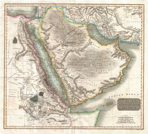
This is an exceptionally fine example of John Thomson's 1817 map of Arabia, Egypt, and Abyssinia. Centered on the Arabian Peninsula, Thomson's map covers from the eastern Mediterranean to the Horn of Africa, and from the Libyan Desert to Persia. The whole of this map is beautifully engraved in the minimalist English style pioneered in the early part of the 19th century. Relief is shown by hachure with towns, caravan routes, cities, and major topographical features identified.
Engraved in 1817, this is the second edition of Thomson's Arabia map and, due to its extraordinary size and detail, is one of the finest maps of Arabia to be published in Europe during the early 19th century. The overall quality and depth of Menzies' engraving is altogether extraordinary and this particular example offers a fine crisp impression, suggesting an early strike off the plate. To create this map Thomson drew information from various sources including earlier maps and contemporary excursions into the region. He identifies several important pilgrimage routes across the Arabian Desert to Mecca, the great Caravan routes from the Nile Valley into the interior of Africa, and the Caravan route from Basra to Aleppo. The 1789 route of the frigate Venus through the Red Sea is especially noteworthy. Vice Admiral Rosily and the Venus explored the Red Sea thoroughly and declared it a practical and navigable avenue for European trade. Previously, the Red Sea had a reputation as dangerous to navigate and was thus largely avoided by the larger European trading vessels. This map deviates from previous versions with regard to the inclusions of more information in the Arabian Peninsula and in the Nile Valley – most of which was most likely drawn from the 1814 – 1816 excursions of John Lewis Burckhardt throughout the region.
This map is a steel plate engraving by J. and G. Menzies, and was prepared by John Thomson for inclusion in the 1817 edition of Thomson's New General Atlas.
Cartographer
John Thomson (1777 - c. 1841) was a Scottish cartographer, publisher, and bookbinder active in Edinburgh during the early part of the 19th century. Thomson apprenticed under Edinburgh bookbinder Robert Alison. After his apprenticeship, he briefly went into business with Abraham Thomson. Later, the two parted ways, John Thomson segueing into maps and Abraham Thomson taking over the bookbinding portion of the business. Thomson is generally one of the leading publishers in the Edinburgh school of cartography, which flourished from roughly 1800 to 1830. Thomson and his contemporaries (Pinkerton and Cary) redefined European cartography by abandoning typical 18th-century decorative elements such as elaborate title cartouches and fantastic beasts in favor of detail and accuracy. Thomson's principle works include Thomson's New General Atlas, published from 1814 to 1821, the New Classical and Historical Atlas of 1829, and his 1830 Atlas of Scotland. The Atlas of Scotland, a work of groundbreaking detail and dedication, would eventually bankrupt the Thomson firm in 1830, at which time their plates were sequestered by the court. The firm partially recovered in the subsequent year, allowing Thomson to reclaim his printing plates in 1831, but filed again for bankruptcy in 1835, at which time most of his printing plates were sold to A. K. Johnston and Company. There is some suggestion that he continued to work as a bookbinder until 1841. Today, Thomson maps are becoming increasingly rare as they are highly admired for their impressive size, vivid hand coloration, and superb detail. More by this mapmaker...
Source
Thomson, J. A New General Atlas, (Edinburgh) 1817.
Condition
Very good condition. Original centerfold exhibits some minor discoloration. Some offsetting. Original plate mark visible. Blank on verso.
References
Rumsey 1007.050. Phillips (Atlases) 731. Newberry Library: Ayer 135 T4 1817.