This item has been sold, but you can get on the Waitlist to be notified if another example becomes available, or purchase a digital scan.
1789 Faden Map of Belgium and Luxemburg or the Low Countries under Austrian Possession
Belgium-faden-1789$250.00

Title
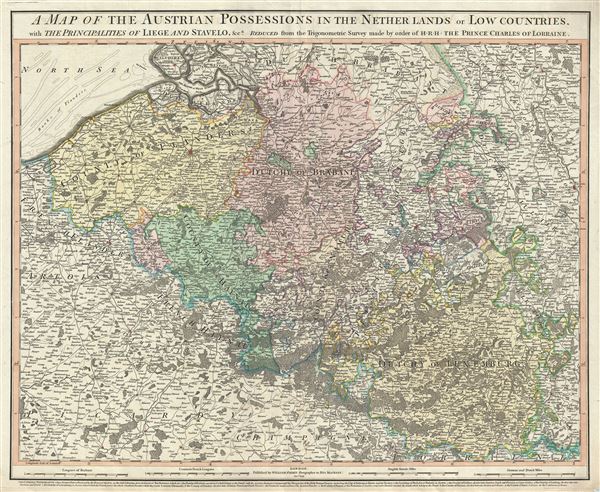
A map of the Austrian possessions in the Netherlands or Low Countries, with the principalities of Liege and Stavelo, etc.
1789 (dated) 22 x 26.5 in (55.88 x 67.31 cm) 1 : 505000
1789 (dated) 22 x 26.5 in (55.88 x 67.31 cm) 1 : 505000
Description
This is an attractive 1789 map of Belgium and Luxemburg by William Faden. The map covers present day Belgium and Luxemburg along with adjacent parts of France and Germany. The map extends from Breda, south as far as Montmedy and from Dunkirk east as to Cologne. The Duchy of Luxemburg is illustrated with exceptional and uncommon detail. When Faden prepared this map, much of this region was dominated by the Hapsburgs of Austria.
The Low Countries were on the low-lying delta formed by the convergence of the Rhine, Scheldt, and Meuse rivers. This portion of the Netherlands was known successively as the Habsburg Netherlands, the Spanish Netherlands, and finally Austrian Netherlands until, in 1795, Napoleonic forces invaded and set up a new French client state, the Batavian Republic. The Low Countries, until 1581 part of the Seventeen United Provinces, were reunited by the 1815 Congress of Vienna as the United Kingdom of the Netherlands. The United Provinces hosted the world's first stock exchanges, and is considered the birthplace of the modern capitalist economy.
This map was based on the trigonometric survey made by order of His Royal Highness, Prince Charles of Lorraine and was published by William Faden, Geographer to His Majesty, in 1789
Cartographer
William Faden (July 11, 1749 - March 21, 1836) was a Scottish cartographer and map publisher of the late 18th century. Faden was born in London. His father, William MacFaden, was a well-known London printer and publisher of The Literary Magazine. During the Jacobite Rebellion (1745 - 1746), MacFaden changed his family name to Faden, to avoid anti-Scottish sentiment. Faden apprenticed under the engraver James Wigley (1700 - 1782), attaining his freedom in 1771 - in the same year that Thomas Jefferys Sr. died. While Thomas Jefferys Sr. was an important and masterful mapmaker, he was a terrible businessman, and his son, Jefferys Jr., had little interest in building on his father's legacy. MacFaden, perhaps recognizing an opportunity, purchased his son a partnership in the Jefferys firm, which subsequently traded as 'Faden and Jefferys'. Jefferys Jr. also inherited Jefferys Sr.'s title, 'Geographer to the King and to the Prince of Wales'. With little interest in cartography or map publishing, Jefferys Jr. increasingly took a back seat to Faden, and by 1776, he had withdrawn from day-to-day management, although he retained his financial stake. The American Revolutionary War (1775 - 1783) proved to be a boom for the young 'Geographer to the King', who leveraged existing materials and unpublished manuscript maps to which he had access via his official appointment to publish a wealth of important maps, both for official use and the curious public - this period of prosperity laid the financial underpinning for Faden, who by 1783, at the end of the war, acquired full ownership of the firm and removed the Jefferys imprint. In 1801, he engraved and published the first maps for the British Ordnance Survey. By 1822, Faden published over 350 maps, atlases, and military plans. He retired in 1823, selling his plates to James Wyld Sr. Faden died in 1836. More by this mapmaker...
Condition
Very good. Original platemark visible. Minor wear and verso repair along original centerfold.
References
Rumsey 2104.014.