This item has been sold, but you can get on the Waitlist to be notified if another example becomes available, or purchase a digital scan.
1730 Homann Heirs Map of Belgium and Luxembourg
BelgiumCatholicum-hmhr-1747$150.00

Title
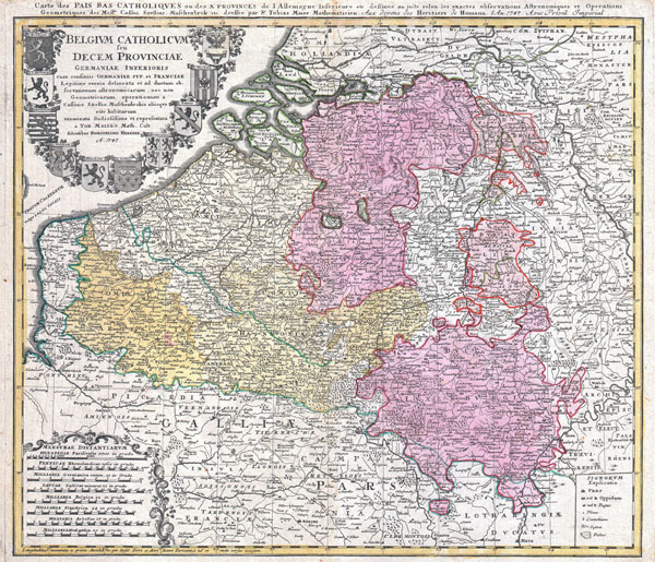
Belgium Catholicum seu Decem provinciae Germaniae Inferioris cum confiniis Germaniae sup. et Franciae… / Carte des Pais Bas Catholiques ou des X Provinces de l'Allemagne Inférieure etc.: legitime omnia delineata et ad ductum observationum astronomicarum, nec non geometricarum operationum a Cassinio, Snellio, Muschenbrokio aliisque rite habitarum, examinata studiosissime et representa a Tob. Maiero math. cult.: dessinée au juste selon les exactes observations astronomiques et operations geometriques de Messr. Cassini, Snellius, Muschenbrok etc. dressée par Sr. Tobias Maier
1747 (dated) 19.25 x 22 in (48.895 x 55.88 cm)
1747 (dated) 19.25 x 22 in (48.895 x 55.88 cm)
Description
A beautifully detailed c. 1730 J. B. Homann map of Belgium and Luxembourg. Depicts Belgium and Luxembourg as well as parts of Holland, France and Germany. The map notes fortified cities, villages, roads, bridges, forests, castles and topography. The title cartouche in the upper left quadrant features the 10 heraldic crests of the nations depicted. Alternative title in French in upper margin. This map was drawn in Nuremberg by Tobias Maier and included in the c. 1752 Homann Heirs Maior Atlas Scholasticus ex Triginta Sex Generalibus et Specialibus…. .
Cartographer
Homann Heirs (1730 - 1848) were a map publishing house based in Nuremberg, Germany, in the middle to late 18th century. After the great mapmaker Johann Baptist Homann's (1664 - 1724) death, management of the firm passed to his son Johann Christoph Homann (1703 - 1730). J. C. Homann, perhaps realizing that he would not long survive his father, stipulated in his will that the company would be inherited by his two head managers, Johann Georg Ebersberger (1695 - 1760) and Johann Michael Franz (1700 - 1761), and that it would publish only under the name 'Homann Heirs'. This designation, in various forms (Homannsche Heirs, Heritiers de Homann, Lat Homannianos Herod, Homannschen Erben, etc..) appears on maps from about 1731 onwards. The firm continued to publish maps in ever diminishing quantities until the death of its last owner, Christoph Franz Fembo (1781 - 1848). More by this mapmaker...
Source
Major Atlas Scholasticus Ex Triginta sex Generalibus et Specialibus Mappis Homannianis..., c. 1752.
Condition
Very good condition. Nice dark impression. Original centerfold.
References
Stanford University, Map Collection, Low C 0214