
This item below is out of stock, but another example (left) is available. To view the available item, click "Details."
Details
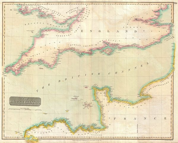
1814 Thomson Map of the English Channel, English and French Coasts
1814 (dated) $250.00
1814 Thomson Map of the English Channel
BritishChannel-thomson-1814$125.00

Title
The British Channel.
1814 (dated) 20.5 x 25.5 in (52.07 x 64.77 cm)
1814 (dated) 20.5 x 25.5 in (52.07 x 64.77 cm)
Description
A fine example of John Thomson's 1814 map of the British or English Channel. Depicts England from Cornwall eastward as far as Canterbury and the Strait of Dover. Extends northward as far as Pembroke Shire and St. Brides Bay. Includes London and the Isle of Wright. On the opposite side of the English Channel this map covers from Goulet Harbor eastward to Boulogne. Minimal inland detail but excellent coastal coverage is offered throughout. During the Napoleonic Wars, which would end at Waterloo just one year after this map was engraved, the English Channel became a major hotbed of smuggling and war profiteering, with English textiles flooding into continental Europe. Thomson maps are known for their stunning color and size, and represent some of the finest cartographic art of the 19th century. Engraved by J. and G. Menzies of Edinburgh for issue as plate no. 15 in the 1817 edition of Thomson's New General Atlas.
Cartographer
John Thomson (1777 - c. 1841) was a Scottish cartographer, publisher, and bookbinder active in Edinburgh during the early part of the 19th century. Thomson apprenticed under Edinburgh bookbinder Robert Alison. After his apprenticeship, he briefly went into business with Abraham Thomson. Later, the two parted ways, John Thomson segueing into maps and Abraham Thomson taking over the bookbinding portion of the business. Thomson is generally one of the leading publishers in the Edinburgh school of cartography, which flourished from roughly 1800 to 1830. Thomson and his contemporaries (Pinkerton and Cary) redefined European cartography by abandoning typical 18th-century decorative elements such as elaborate title cartouches and fantastic beasts in favor of detail and accuracy. Thomson's principle works include Thomson's New General Atlas, published from 1814 to 1821, the New Classical and Historical Atlas of 1829, and his 1830 Atlas of Scotland. The Atlas of Scotland, a work of groundbreaking detail and dedication, would eventually bankrupt the Thomson firm in 1830, at which time their plates were sequestered by the court. The firm partially recovered in the subsequent year, allowing Thomson to reclaim his printing plates in 1831, but filed again for bankruptcy in 1835, at which time most of his printing plates were sold to A. K. Johnston and Company. There is some suggestion that he continued to work as a bookbinder until 1841. Today, Thomson maps are becoming increasingly rare as they are highly admired for their impressive size, vivid hand coloration, and superb detail. More by this mapmaker...
Source
Thomson, J. A New General Atlas, (Edinburgh) 1814.
Condition
Very good condition. Light transference.
References
Rumsey 1007.015. Phillips (Atlases) 731. Newberry Library: Ayer +135 T4 (1817 edition).