This item has been sold, but you can get on the Waitlist to be notified if another example becomes available, or purchase a digital scan.
1708 Delisle Map of Southern Africa
CarteDuCongo-delisle-1708$200.00

Title
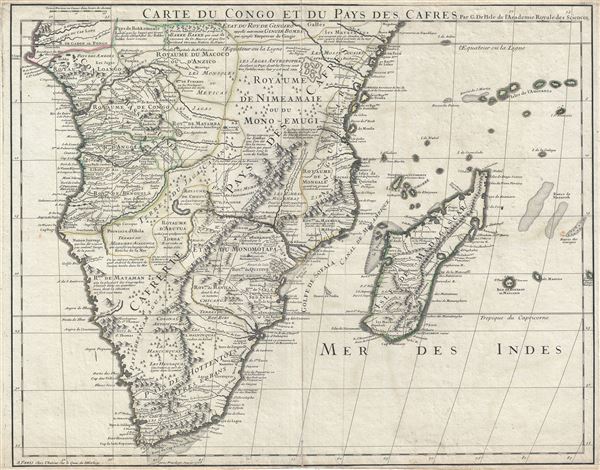
Carte du Congo et du Pays des Cafres.
1708 (dated) 19.5 x 24.5 in (49.53 x 62.23 cm) 1 : 9100000
1708 (dated) 19.5 x 24.5 in (49.53 x 62.23 cm) 1 : 9100000
Description
This is an extraordinary example of Guillaume De L'isle's 1708 important map of Africa south of the Equator. It depicts southern Africa in stunning detail with numerous notations and comments regarding the people, geography, and wildlife of the region.
De L'isle was a very cautious and scientific cartographer, basing his maps on the first hand reports from sailors, merchants and missionaries that, at the time, were flowing into Paris at an unprecedented rate. This map offers significant detail throughout the interior naming numerous tribal areas and kingdoms including the Jaga, the Kongo, the Angola, the Kingdom of Numeamaie or Mono-Emugi, Monomotapa, Gingiro, and others.
The Kingdom of Gingiro is known from the reports of the Jesuit Anton-Fernandez who traveled to the region in 1613 on a mission for King Philip II of Spain. Anton-Fernandez offer a wealth of detail about the Kingdom nothing that Gingiro means 'monkey' in the local language and that the king himself a kind of monkey-God. One hundred years later, when De L'isle drew this map, Anton-Fernandez's journal remained one of the few reports of this region available and, for want more up to date information, was incorporated. Most other regions of Africa rely on equal vagarious references.
Shows the Portuguese trading colonies of Sena and Tete (Santiago) on the Zambezi River. Also near the Zambezi, 'La Victoire Couvent de Dominicains' is worth of mention. Also notes the predominantly Arab island kingdoms of Pemba and Zanzibar. Identifies the Dutch colonies near the Cape of Good Hope, including 'Fort Hollandois' (Cape Town).
Near the Equator, De L'isle identifies an enormous lake almost exactly in the modern location and form of Lake Victoria. He notes that this is a 'Grand Lac place sur le raport des Negres.' What is remarkable about this is not the appearance of a lake in this region, one of the two Ptolemaic sources of the Nile appeared on maps of this area for hundreds of years, but rather that it seems to be based on actual evidence and it is not connected to any of the great African river systems. It seems highly likely that this is one of the first clear references to Lake Victoria to appear on a map.
This map was created by Guillaume De L'isle in 1708.
Cartographer
The De L'Isle family (fl. c. 1700 - c. 1760) (also written Delisle) were, in composite, a mapmaking tour de force who redefined early 18th century European cartography. Claude De L'Isle (1644 -1720), the family patriarch, was Paris based a historian and geographer under Nicholas Sanson. De L'Isle and his sons were proponents of the school of "positive geography" and were definitive figures, defining the heights of the Golden Age of French Cartography. Of his twelve sons, four, Guillaume (1675 - 1726), Simon Claude (1675 - 1726), Joseph Nicholas (1688 - 1768) and Louis (1720 - 1745), made a significant contributions to cartography. Without a doubt Guillaume was the most remarkable member of the family. It is said that Guillaume's skill as a cartographer was so prodigious that he drew his first map at just nine years of age. He was tutored by J. D. Cassini in astronomy, science, mathematics and cartography. By applying these diverse disciplines to the vast stores of information provided by 18th century navigators, Guillaume created the technique that came to be known as "scientific cartography", essentially an extension of Sanson's "positive geography". This revolutionary approach transformed the field of cartography and created a more accurate picture of the world. Among Guillaume's many firsts are the first naming of Texas, the first correct map of the Mississippi, the final rejection of the insular California fallacy, and the first identification of the correct longitudes of America. Stylistically De L'Isle also initiated important changes to the medium, eschewing the flamboyant Dutch style of the previous century in favor of a highly detailed yet still decorative approach that yielded map both beautiful and informative. Guillaume was elected to the French Academie Royale des Sciences at 27. Later, in 1718, he was also appointed "Premier Geographe du Roi", an office created especially for him. De L'Isle personally financed the publication of most of his maps, hoping to make heavy royalties on their sales. Unfortunately he met an untimely death in 1728, leaving considerable debt and an impoverished child and widow. De L'Isle's publishing firm was taken over by his assistant, Phillipe Buache who became, posthumously, his son in law. The other De L'Isle brothers, Joseph Nicholas and Louis De L'Isle, were employed in the Service of Peter the Great of Russia as astronomers and surveyors. They are responsible for cataloguing and compiling the data obtained from Russian expeditions in the Pacific and along the northwest coast of America, including the seminal explorations of Vitus Bering and Aleksei Chirikov. The De L'Isles, like their rivals the Vaugondys , must be considered speculative geographers. Speculative geography was a genre of mapmaking that evolved in Europe, particularly Paris, in the middle to late 18th century. Cartographers in this genre would fill in unknown areas on their maps with speculations based upon their vast knowledge of cartography, personal geographical theories, and often dubious primary source material gathered by explorers and navigators. This approach, which attempted to use the known to validate the unknown, naturally engendered many rivalries. The era of speculatively cartography effectively ended with the late 18th century explorations of Captain Cook, Jean Francois de Galaup de La Perouse, and George Vancouver. More by this mapmaker...
Condition
Very good. Minor wear and verso reinforcement along original centerfold. Minor offsetting and foxing. Original platemark visible.
References
Rumsey 4764.092.