This item has been sold, but you can get on the Waitlist to be notified if another example becomes available, or purchase a digital scan.
1900 Department of Interior Map of Chickasaw Nation Indian Territory
ChickasawNation-mcalpine-1900$175.00

Title
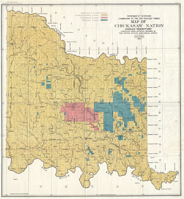
Department of Interior Commission to the Five Civilized Tribes Map of Chickasaw Nation Indian Territory Compiled from Official Records of The United States Geological Survey.
1900 (dated) 34 x 31.5 in (86.36 x 80.01 cm) 1 : 240000
1900 (dated) 34 x 31.5 in (86.36 x 80.01 cm) 1 : 240000
Description
This is a scarce and beautiful 1900 R. L. McAlpine map of the Chickasaw Nation issued by the Department of Interior Commission of the Five Civilized Tribes and compiled from the official records of the United States Geological Survey. Part of modern day Oklahoma, the map is centered on Old Fort Arbuckle and covers the Chickasaw Nation as it was located between the Canadian River and the Red River. It notes several rivers, towns, and topography throughout. The map is covered in grids noting the survey conducted by the U. S. G. S. and is color coded to show agricultural land in yellow, mountain land in pink and rocky land in green.
During the Indian removal of the 1830s, known as the 'Trail of Tears,' the Chickasaw Indians were forcibly relocated from their ancestral lands in Tennessee, Alabama and Mississippi westward to the federally recognized native American nation, the Chickasaw Nation, located in the Indian Territory (modern day Oklahoma).
The Chickasaw Nation was a member of the Five Civilized Tribes along with Cherokee, Seminole, Choctaw and Muskogee nations. The Commission to the Five Civilized Tribes, or the Dawes Commission, was created in 1893 to negotiate with the Five Civilized Tribes to divide their lands amongst individual members of the tribes. This map was most likely used for that purpose. Eventually Oklahoma would be admitted to the Union in 1907 and the 'Five Civilized Tribes' would lose most of their tribal lands.
This map was compiled and drawn by R. L. McAlpine and engraved by Julius Bien and Co. Issued in the Eight Annual Report of the Commission to the Five Civilized Tribes as Exhibit 7.
CartographerS
The Office of the Coast Survey (later the U.S. Geodetic Survey) (1807 - present), founded in 1807 by President Thomas Jefferson and Secretary of Commerce Albert Gallatin, is the oldest scientific organization in the U.S. Federal Government. Jefferson created the "Survey of the Coast," as it was then called, in response to a need for accurate navigational charts of the new nation's coasts and harbors. The first superintendent of the Coast Survey was Swiss immigrant and West Point mathematics professor Ferdinand Hassler. Under the direction of Hassler, from 1816 to 1843, the ideological and scientific foundations for the Coast Survey were established. Hassler, and the Coast Survey under him developed a reputation for uncompromising dedication to the principles of accuracy and excellence. Hassler lead the Coast Survey until his death in 1843, at which time Alexander Dallas Bache, a great-grandson of Benjamin Franklin, took the helm. Under the leadership A. D. Bache, the Coast Survey did most of its most important work. During his Superintendence, from 1843 to 1865, Bache was steadfast advocate of American science and navigation and in fact founded the American Academy of Sciences. Bache was succeeded by Benjamin Pierce who ran the Survey from 1867 to 1874. Pierce was in turn succeeded by Carlile Pollock Patterson who was Superintendent from 1874 to 1881. In 1878, under Patterson's superintendence, the U.S. Coast Survey was reorganized as the U.S. Coast and Geodetic Survey (C & GS or USGS) to accommodate topographic as well as nautical surveys. Today the Coast Survey is part of the National Oceanic and Atmospheric Administration or NOAA. More by this mapmaker...
Julius (Julien) Bien (September 27, 1826 - December 21, 1909) was a German-Jewish lithographer and engraver based in New York City. Bien was born in Naumburg, Germany. He was educated at the Academy of Fine Arts, Cassell and at Städel's Institute, Frankfurt-am-Main. Following the suppression of the anti-autocratic German Revolutions of 1848, Bien, who participated in the pan-German movement, found himself out of favor in his home country and joined the mass German immigration to the United States. Bien can be found in New York as early as 1849. He established the New York Lithographing, Engraving & Printing Company in New York that focused on the emergent chromo-lithograph process - a method of printing color using lithographic plates. His work drew the attention of the U.S. Government Printing Office which contracted him to produce countless government maps and surveys, including the Pacific Railroad Surveys, the census, numerous coast surveys, and various maps relating to the American Civil War. Bien also issued several atlases both privately and in conjunction with a relation, Joseph Bien. At the height of his career Bien was elected president of the American Lithographers Association. After his death in 1909, Bien's firm was taken over by his son who promptly ran it into insolvency. The firm was sold to Sheldon Franklin, who, as part of the deal, retained the right to publish under the Julius Bien imprint. In addition to his work as a printer, Bien was active in the New York German Jewish community. He was director of the New York Hebrew Technical Institute, the New York Hebrew Orphan Asylum, and president of the B'nai B'rith Order. Learn More...
Source
Eight Annual Report of the Commission to the Five Civilized Tribes, 1900.
Condition
Very good. Minor wear along original fold lines. Minor spotting at places.