
This item below is out of stock, but another example (left) is available. To view the available item, click "Details."
Details
1944 Turner Map of the World During World War II
1944 (dated) $300.00
1942 Turner Pictorial Map of Europe and North Africa During World War II
DatedEventsThirdEdition-turner-1942$125.00

Title
Dated Events War Map.
1942 (dated) 20 x 26.25 in (50.8 x 66.675 cm) 1 : 13824000
1942 (dated) 20 x 26.25 in (50.8 x 66.675 cm) 1 : 13824000
Description
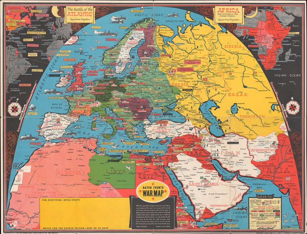
This is a 1942 Stanley Francis Turner pictorial map of Europe, North Africa, and the rest of the world during World War II. Created as a visual summary of the war, text boxes highlight and summarize the most important events between 1939 and 1942. Among the events cited are the declarations of war by both sides, the Nazi invasions of the Low Countries, France, and Russia, the evacuation at Dunkirk, and the fighting in North Africa between Rommel and Montgomery. Germany is shaded dark green and all of its conquests, including Occupied France, are identified using various shades of green. Hungary, Romania, Bulgaria, and Finland all appear in dark purple, signifying their alliance with the Axis powers. Nations shaded white, such as Iran, Afghanistan, Saudi Arabia, Turkey, Ireland, Switzerland, and Spain, are neutral. Vichy France, with its own special status, appears in orange. Icons mark capital cities, with Big Ben in London, the Eiffel Tower in Paris, and the Pantheon in Rome. Destroyers and battleships ply the waters of the Atlantic and Mediterranean.
The Insets
Using an unconventional semi-oval projection, Turner creates space in the upper left and right corners for insets expanding the coverage of the map globally. Turner presents the Battle of the Atlantic in the upper left. Here, he identifies important port cities on both sides of the Atlantic. Turner also uses text boxes to reference important events, such as the declarations of war, the Lend-Lease Act, and the Atlantic Charter. On the right, Turner includes the rest of Africa. Here, he shades all the countries under British control red. The Belgian Congo and French Equatorial Africa appear in lighter red, signifying their allegiance to the Allied cause. The rest of the continent is gray highlighting that it has sided with the Axis powers.The Verso
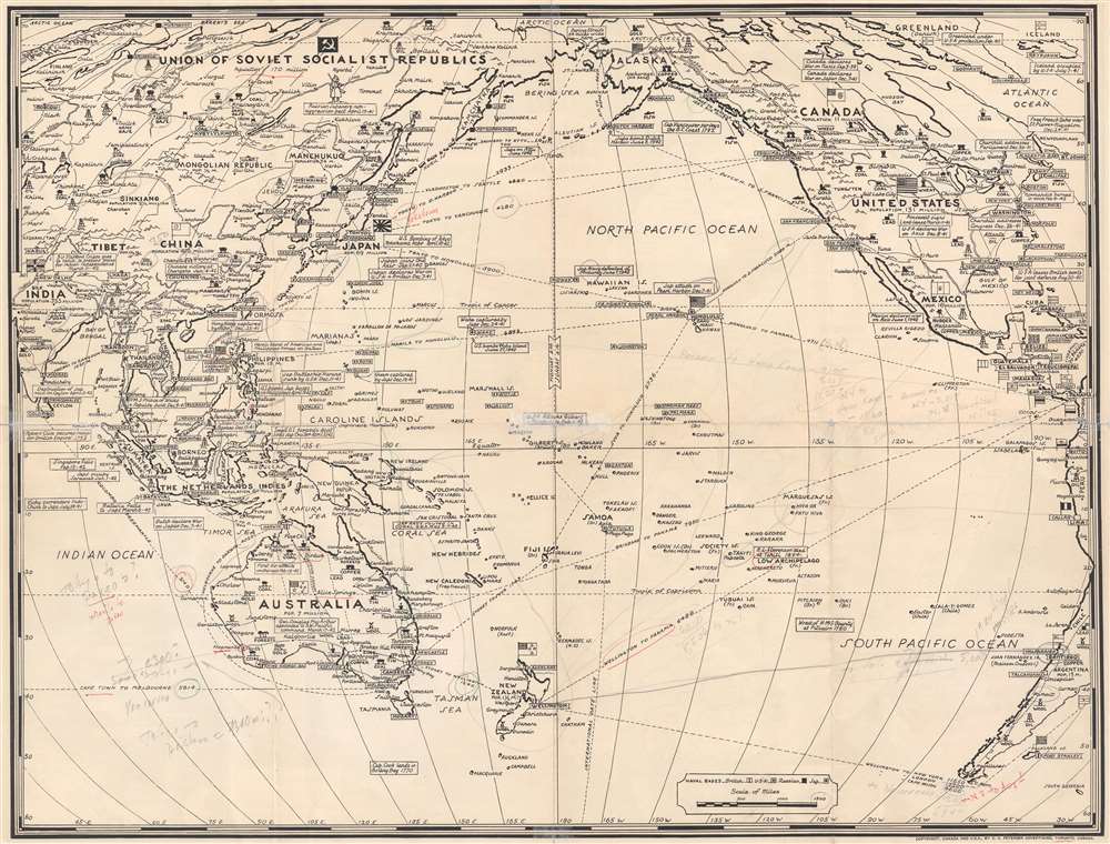
A black and white map of the Pacific is printed on the verso. Turner employs many of the same conventions as on the front, including the text boxes to mark important events, including the Japanese attack on Pearl Harbor, the U.S. victories at Midway and the Coral Sea, and the 'heroic stand of American and Philippino Forces on Bataan'. Banners mark important cities and icons highlight the presence of strategic natural resources.Publication History and Census
This map was created by Stanley Francis Turner and published by C. C. Peterson between August and November 1942. We are able to say that this map was published before November 1942 because the Allied invasion of North Africa, called Operation Torch, does not appear. Turner published a series of Dated Events War Maps throughout World War II, updating the map regularly and redesigning it several times. The present example represents the third edition of Turner's map and is not cataloged in OCLC. An example is part of the David Rumsey Map Collection.Cartographer
Stanley Francis Turner (1883 – 1953) was a visual artist and painter based in Toronto, Canada. Turner was born in Aylesbury, England. He studied art in London at the South Kensington School before migrating to Canada in 1903, where he studied at Ontario College of Art under George Reid and J. W. Beatty. Turner is best known as a painter and designer capable of working in a variety of mediums. During World War II, Turner took a contract with the Globe and Mail to illustrate pictorial maps of war events. Turner may have maintained the rights to his war maps, as he also seems to have had a contract with the advertiser and publisher, C.C. Peterson, also of Toronto, to publish and distribute his maps in the United States. Turner's maps are information dense and designed to illustrate the events of the war in an easily digestible pictorial format. Turner experimented with different ways of working with the cartographic ranging from simple Mercator projections to more contemporary equal-area projections. In 1930, Turner was elected an Associate of the Royal Canadian Academy of Arts. He died in Toronto in 1953. More by this mapmaker...
Condition
Good. Exhibits wear along original fold lines. Old cellophane tape repairs evident on verso. Map of the Pacific Ocean printed on verso. Manuscript notations evident on both sides in pencil and pen.
References
Rumsey 8343.001.