
Turner, Stanley Francis

Stanley Francis Turner (1883 – 1953) was a visual artist and painter based in Toronto, Canada. Turner was born in Aylesbury, England. He studied art in London at the South Kensington School before migrating to Canada in 1903, where he studied at Ontario College of Art under George Reid and J. W. Beatty. Turner is best known as a painter and designer capable of working in a variety of mediums. During World War II, Turner took a contract with the Globe and Mail to illustrate pictorial maps of war events. Turner may have maintained the rights to his war maps, as he also seems to have had a contract with the advertiser and publisher, C.C. Petersen, also of Toronto, to publish and distribute his maps in the United States. Turner's maps are information dense and designed to illustrate the events of the war in an easily digestible pictorial format. Turner experimented with different ways of working with the cartographic ranging from simple Mercator projections to more contemporary equal-area projections. In 1930, Turner was elected an Associate of the Royal Canadian Academy of Arts. He died in Toronto in 1953.
Rare Second edition of Turner's 'Dated Events War Map'. - the earliest we've seen.
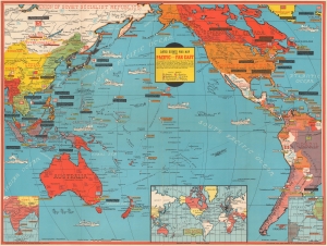
Dated Events War Map of the Pacific and Far East.
$450.00
Acquire
- Digital Map Information
- Suitable for large format printing
- File Size: 32.41 MB
- File Type: ZIP / TIFF
- ICC color profile embedded
- Delivered instantly via download link
This is a January 1942 Stanley Francis Turner Dated Events War Map of the Pacific and East Asia, published less than a month after the Japanese attack on Pearl Harbor. Turner produced the 'Dated Events War Map' series throughout World War II (1939 - 1945), creating more than 25 maps, which, as a whole, present a comprehensive cartographic overview of war events as they unfolded. The present map is the Second Edition, the earliest 'Dated War Events' map we have encountered - we've never seen the first issue. (more details)
WWII in the Pacific through October 1944.
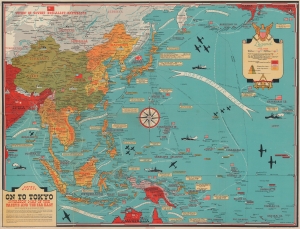
Dated Events. On to Tokyo. Invasion Map of the Pacific and the Far East. Eighth Edition. / War in Europe. Dated Events.
$425.00
Acquire
This is a Stanley Francis Turner map of the Pacific Theater of World War II (1939 - 1945), published in late October or early November 1944. As with Turner's other World War II maps, short text boxes highlight important events during the war up to publication, in this case from the Japanese attack on Pearl Harbor on December 7, 1941, until the U.S. invasion of the Philippines on October 17, 1944. (more details)
The last year of WWII.
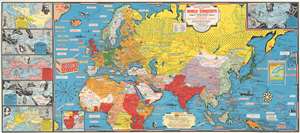
Dated Events Map of World Conquests Showing Axis Attempt at World Conquest.
$650.00
Acquire
- Digital Map Information
- Suitable for large format printing
- File Size: 39.39 MB
- File Type: ZIP / TIFF
- ICC color profile embedded
- Delivered instantly via download link
This 1944 Stanley Francis Turner map of Europe, Africa, and Asia illustrates the world on the eve of 1945, the final year of World War II (1939 - 1945). Text boxes scattered throughout chronicle important wartime events, including the D-Day invasion of France, the liberation of Paris, and MacArthur's return to the Philippines, along with numerous others. The United Nations are shaded red, while land controlled by the Axis is green. Light green areas (limited to Asia only) illustrate conquered areas still controlled by the Axis. Countries are labeled and bear their flag, while world capitals are marked by yellow banners and small icons of buildings. Illustrations of airplanes and warships dot the map. Aerial distance charts to Berlin and Tokyo also appear. A small inset along the bottom border illustrates southern Africa and Madagascar and uses the same color scheme to portray alliances. (more details)