This item has been sold, but you can get on the Waitlist to be notified if another example becomes available, or purchase a digital scan.
1743 Homann Heirs - Haas Map of Europe
Europa-hmhr-1743$100.00

Title
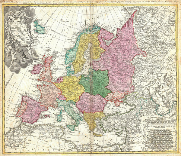
Europa Secundum legitimas Projectionis Stereographicae regulas et juxta recentissimas observationes aeque ac relationes… / L'Europe, dessinee suivant les Regles le plus precises d'une nouvelle Projection Stereographique, tiree des Observations et des Relations les plus modernes et appuyee en divers endroits des Monumens antiques, dressee et divisee methodiquement par Iean Mattias Has Profess. Ordin des Mathematiques: Publiee par les Heritiers d'Homann L'An 1743
1743 (dated by hand) 19 x 22 in (48.26 x 55.88 cm)
1743 (dated by hand) 19 x 22 in (48.26 x 55.88 cm)
Description
A beautifully detailed 1743 Johann Matthais Haas map of Europe. Depicts all of Europe including Iceland and parts of North Africa and Asia. Color coded according to sovereign nation. Elaborate title cartouche in the upper left quadrant features Europa, an angel, numerous crowns representing the royal houses of Europe, three children and several horses. Alternative title in French in top margin, L'Europe dessinee Suivant les Regles... This map was drawn in Nuremberg by Johann Matthais Haas for inclusion the 1752 Homann Heirs Maior Atlas Scholasticus ex Triginta Sex Generalibus et Specialibus…. .
CartographerS
Homann Heirs (1730 - 1848) were a map publishing house based in Nuremberg, Germany, in the middle to late 18th century. After the great mapmaker Johann Baptist Homann's (1664 - 1724) death, management of the firm passed to his son Johann Christoph Homann (1703 - 1730). J. C. Homann, perhaps realizing that he would not long survive his father, stipulated in his will that the company would be inherited by his two head managers, Johann Georg Ebersberger (1695 - 1760) and Johann Michael Franz (1700 - 1761), and that it would publish only under the name 'Homann Heirs'. This designation, in various forms (Homannsche Heirs, Heritiers de Homann, Lat Homannianos Herod, Homannschen Erben, etc..) appears on maps from about 1731 onwards. The firm continued to publish maps in ever diminishing quantities until the death of its last owner, Christoph Franz Fembo (1781 - 1848). More by this mapmaker...
Johann Matthias (Matyhias) Haas (Hasio, Haase) (Latinized as Johannes Hasius) (January 14, 1684 - September 24, 1742) was a German mathematician, astronomer, and cartographer. Haas was born in Augsburg but is known to have held academic positions in Nuremburg, Leipzig and Wittenberg, where he was a professor of mathematics. He produced several maps for the Homann Heirs firm in addition to several publications of his own. Today is memorialized by a crater on the Moon - Hase Crater. Learn More...
Source
Major Atlas Scholasticus Ex Triginta sex Generalibus et Specialibus Mappis Homannianis..., 1752.
Condition
Very good condition. Slight centerfold discoloration. Minor foxing to margins.