This item has been sold, but you can get on the Waitlist to be notified if another example becomes available, or purchase a digital scan.
1848 Edmond Blunt Nautical Chart or Map of Florida and the Bahama Banks
Florida-blunt-1848$2,500.00

Title
The Bahama Banks and the Gulf of Florida.
1848 (dated) 40 x 50 in (101.6 x 127 cm)
1848 (dated) 40 x 50 in (101.6 x 127 cm)
Description
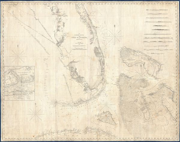
A scarce, detailed, and highly attractive 1848 nautical chart or maritime map of Florida and the Bahamas by e. and G. W. Blunt. The chart covers Florida from 29°37' N, or, roughly speaking, from the latitue of Lake George south past the Florida Keys (then called the Florida Reef), as far as Cuba and from the longitude of Cape St. George eastwards to include the Bahama Islands. The map features limited inland detail but a fine mapping of coastal regions and countless depth soundings, especially around Tampa Bay, the Florida Keys, and throughout the Bahama Banks - a notoriously dangerous area for ships even with such a fine chart as this. An inset in the lower left quadrant focuses on Key West and the surrounding reefs. Around this time wrecking - the practice of salvaging from shipwrecks - had turned Key West into the richest city in Florida. Blunt attributes his inset of Key West to George Gauld, a late 18th century British naval surveyor who produced several extensive surveys of the area. The remainder of the chart is attributed to the work of Colonel Albert of the U.S. Topographical Bureau and U.S. Navy Surveyor Commander Powell. Twelve shore profiles decorate the upper right quadrant. Blunt's chart, which first appeared in his 10 sheet maritime atlas of 1827, represents the height of Nautical mapping in and around the Florida peninsula until the work of the U.S. Coast Survey in the 1850s.
Cartographer
Edmund March Blunt (June 20, 1770 - 1862) was an American navigator, bookseller, chartmaker, and cartographer based in Newburyport, Massachusetts. Blunt was born in Portsmouth, New Hampshire in 1770. In 1796, along with the nominal assistance of prominent navigator Captain Lawrence Furlong, Blunt published The American Coast Pilot, one of the most important published works on American navigation. Although much of the work was plagiarized from British publications, the Coast Pilot was an immediate popular success. In response to the popularity of his work, Blunt published 21 subsequent editions, each with important updates and revisions. The first edition to contain map plates was printed in 1804. Following a fire that destroyed his offices at The Sign of the Bible in 1811, Blunt moved his business to New York and opened a new shop, The Sign of the Quadrant. His sons Edmund Jr. (1799 - 1866) and George William (1802 - 1878), joined the firm in 1824 and eventually took over the family business, renaming the firm 'E. and G. W. Blunt'. They both produced their own nautical books, charts, and instruments, as well as republished their father’s work. In 1830, Edmund accepted a position under Ferdinand Hassler at the United States Office of the Coast Survey. Much of Blunt's original work eventually found its way into U.S. Coast Survey Publications. George closed the firm in 1872 and sold the plates and chart copyrights to the U.S. Coast Survey and the U.S. Navy Hydrographic Office. Due to the quality and detail of Blunt's work, revised editions of his most important charts were republished well into the 1880s. More by this mapmaker...
Condition
Very good. A working nautical chart, some pencil marks and soiling related to navigational usage, professionally flattened and backed with fresh linen.
References
Rumsey 4662.000. Phillips. 3661; Guthorn. p.9-10, 56, 92-93, 160-161. Guthorn, United States coastal charts, p. 10, 156 -158 (1834-1860 eds.)