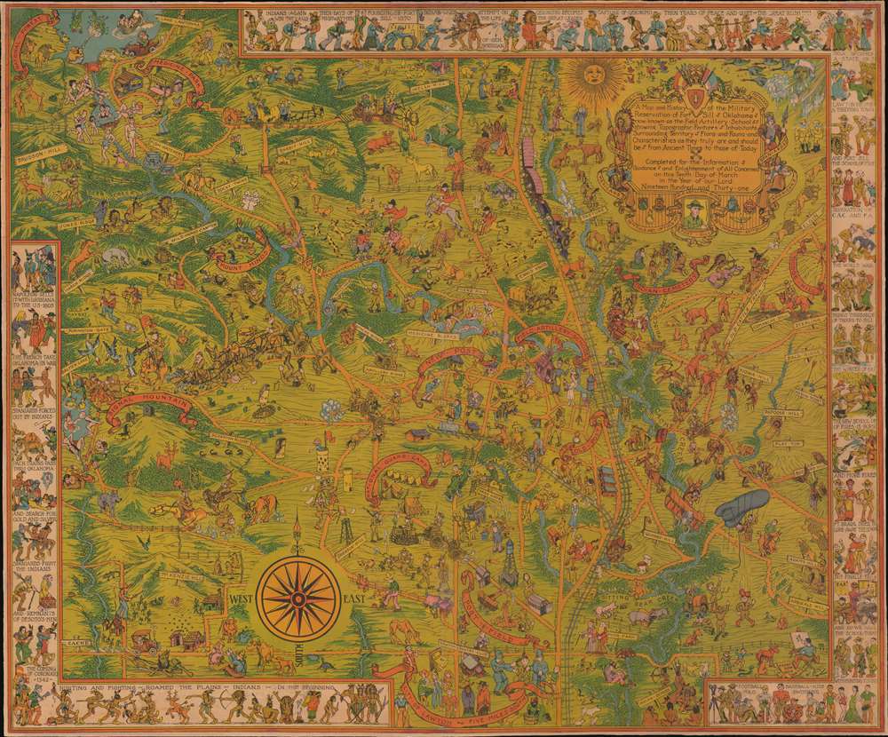
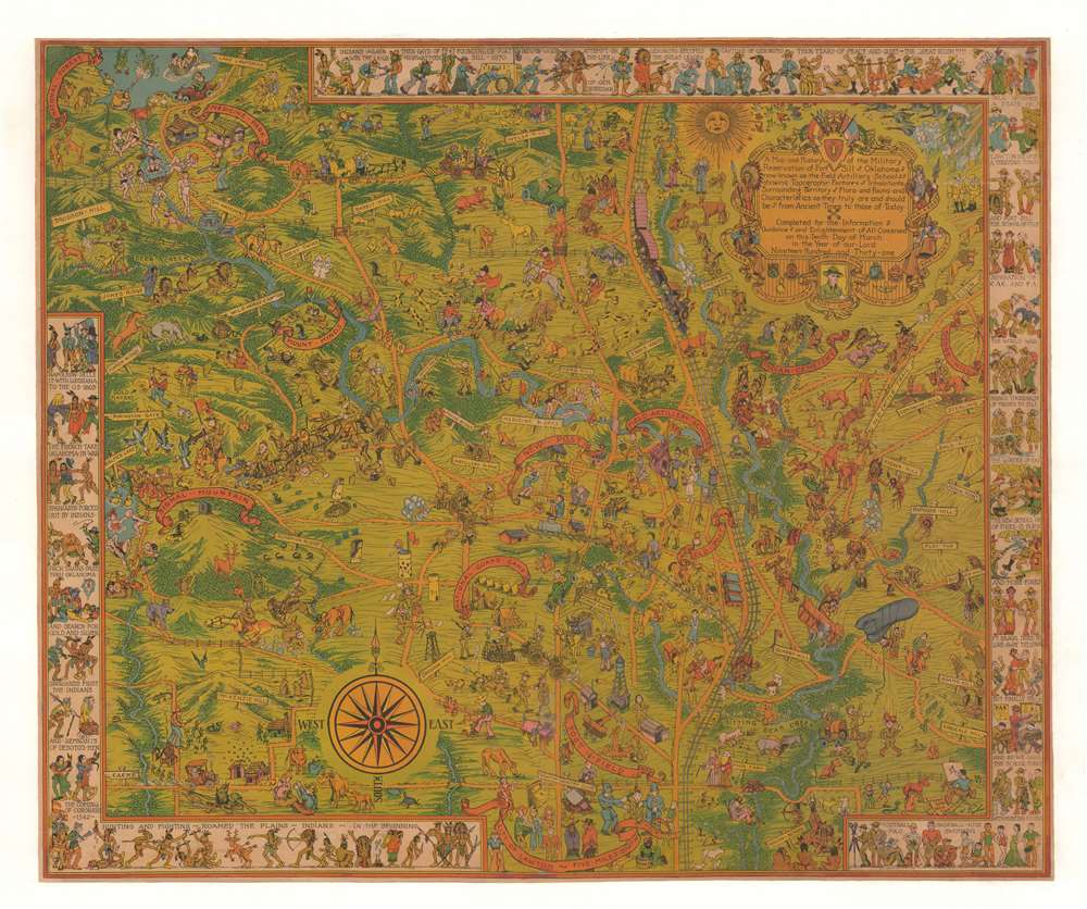
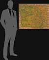
1931 Frank Dorn Pictorial Map of Fort Sill, Oklahoma
FortSill-frankdorn-1931$1,100.00

Title
A Map and History of the Military Reservation of Fort Sill Oklahoma now known as the Field Artillery School showing Topographic Features Inhabitants Surrounding Territory Flora and Fauna and Characteristics as they Truly are and should be from Ancient Times to those of Today.
1931 (dated) 27.5 x 33 in (69.85 x 83.82 cm)
1931 (dated) 27.5 x 33 in (69.85 x 83.82 cm)
Description
This 1931 pictorial map of Fort Sill, Oklahoma, is Frank Dorn's earliest known map. Embracing Fort Sill and the surrounding area, Dorn's synthesis of comic pictorial cartography, history, and vignettes of day-to-day life offer a broad picture of the military experience on base. Dorn is most famous for his Map and History of Peiping, which achieved wide acclaim and distribution. His other maps, all depicting military bases where he was stationed, including this his first map, were issued in much lower quantities and are all extremely rare.
Dorn as an Artist
As is evident here, by 1931, although there are no known earlier maps, Dorn has already developed a sophisticated and distinctive personal style. The map is composed of countless vignettes that poke fun at military life, while detailing the region's points of interest, local lore, vernacular nomenclature, and history. About 3/4 of the border presents a comic clockwise history of the region, from early American Indian Settlement to the founding of the Field Artillery School.Fort Sill
Fort Sill is a U.S. Army based near Lawton, Oklahoma. The enormous base covers some 94,000 acres. It was founded in 1869 by Major General Sheridan during the Indian Wars. Initially called Camp Wichita, Sheridan renamed it after his friend and fellow West Point alum Brigadier General Joshua W. Sill (1831 - 1932). Fort Sill played a significant role in the subsequent Indian Wars. Later, during World War I, early aviators used the base to develop combat aviation tools and techniques. Sill is thus considered the birthplace of American military aviation. In 1917, after the United States entered World War I, the Field Artillery School, where Dorn was a professor, opened and remains active at Fort Sill to this day.Publication History and Census
This map was drawn and published by Frank Dorn while at Fort Sill, Oklahoma, in 1931. The printer remains unknown. It is rare. We are aware of two that have sold in recent decades. Institutionally, we note one example in the OCLC, at the University of Utah. A second example is part of the David Rumsey Collection.Cartographer
Frank 'Pinky' Dorn (June 25, 1901 - July 26, 1981) was an American artist,'old China hand,' and military officer active in East Asia during the middle part of the 20th century. Dorn was born in San Francisco California and later studied at West Point after which he was commissioned in the Field Artillery. He served in the Philippines from 1926 to 1929 and became an instructor at the Field Artillery School at Fort Sill from 1930 to 1933. It was there in 1931 that his produced his first pictorial map, detailing Fort Sill. Between 1931 and 1936, he completed additional pictorial maps of For McKinley and Fort Stotsenburg. Dorn was stationed in Beijing in 1934 where he studied Chinese. It was during this period that Dorn made his greatest contribution to cartography, his iconic pictorial Map and History of Peiping. Dorn's important maps, issued from 1831 to 1936, followed in the artistic-cartographic style of Jo Mora (1876 - 1947), with whom he was acquainted and whose work he admired. During World War II (1939 - 1945) he was assigned as an aide to Brigadier General 'Uncle Joe' Stilwell in the Burma theater under whom he served from 1939 - 1942. There is some indication that Dorn may have served as a field cartographer under Stilwell, but none of these maps are known to have survived. After the war, he was elevated to the rank of Brigadier General and served from 1944 to 1945 as the commander of the China Training and Combat Command. Dorn retired 1953 and returned to San Francisco where he devoted the remainder of his life to painting. He got involved with the psychedelic movement and produced a number of paintings to this effect. Dorn died in 1981 and was buried with full military honors at Arlington National Cemetery. More by this mapmaker...
Condition
Good. Laid on linen, poster style. Some large tears expertly repaired. Minor infill here and there.
References
OCLC 945771335. Rumsey 9761.000.