This item has been sold, but you can get on the Waitlist to be notified if another example becomes available, or purchase a digital scan.
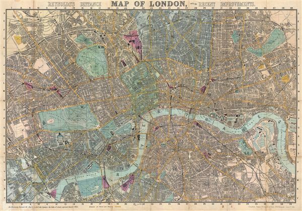
1891 Reynolds Map of London, England
London-reynolds-1891$300.00

Title
Reyonlds's Distance Map of London with the Recent Improvements.
1891 (dated) 21 x 30 in (53.34 x 76.2 cm) 1 : 18100
1891 (dated) 21 x 30 in (53.34 x 76.2 cm) 1 : 18100
Description
An attractive example of the 1891 issue of Reynolds' 'Distance map of London,' alternately titled the 'Shilling Coloured Map of London.' Centered on the Thames River, this map covers London from Highbury to the West India Docks and from Peckham to West Kensington. It is divided into quarter mile squares. The map shows all omnibus and train routes as well as streets, parks, government buildings, rail stations, palaces, and churches. Hand colored in red and green pastels. This was one of the popular pocket maps of London. Reynolds first issued this map in 1857 and it was updated annually to 1901, by which time Charles Smith and Sons had taken over the Reynolds firm.
Cartographer
James Reynolds (1817-1876) was a London based map and chart publisher active in the mid-19th century. Reynolds produced numerous maps and tourist guides of London and the surrounding areas as well as various astronomical and scientific charts. After Reynolds retired his sons, William Henry and Frederick, took over his business, updating and reprinting many of his maps and charts before selling the firm to Charles Smith in the late 19th century. Reynolds operated out of office at 174 Strand Street, London. More by this mapmaker...
Condition
Good. Wear on original fold lines. Professionally flattened and backed with archival tissue.