This item has been sold, but you can get on the Waitlist to be notified if another example becomes available, or purchase a digital scan.
1742 Covens and Mortier Map of Martinique
Martinique-covensmortier-1742$275.00

Title
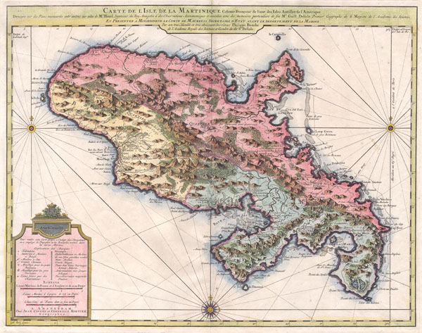
Carte de l'Isle de la Martinique, colonie francoise de l'une des Isles Antilles de l'Amerique. Dressee sur des plans manuscrits entr'autres sur celui de Mr. Houel, Ingenieur du Roy, assujetis a des observations astonomiques et concilies avec des memoires particuliers de feu Mr. Guill. Delisle, Premier Geographe de S. Majeste de l'Academie des Sciences. Et presentee a Monseigneur le Comte de Maurepas, Secretaire d'Etat ayant le departement de la Marine par ... Philippe Buache de l'Academie Royale des Sciences et Gendre du dit Sr. Delisle. A Amsterdam, Chez Jean Covens et Corneille Mortier, Geographes.
c. 1742 (undated) 18.5 x 23.5 in (46.99 x 59.69 cm)
c. 1742 (undated) 18.5 x 23.5 in (46.99 x 59.69 cm)
Description
A beautiful example of Covens & Mortier's 1742 map of the French colony of Martinique in the West Indies. Depicts the Island of Martinique divided into three sections, two in the south and one in the north. Includes both political and topographical information. Beautifully hand colored. Based upon the work of Guillaume DE L'ISLE (1675-1726) and Phillippe BUACHE (1700-1773). Prepared for the 1742 issue of Covens and Mortier's Atlas Nouveau.
Cartographer
Covens and Mortier (1721 - c. 1862) was an Amsterdam publishing firm, the successor to the extensive publishing empire built by Pierre Mortier (1661 - 1711). Covens and Mortier maps are often criticized as derivative - but this is not fully the case. Pierre Mortier lived in Paris from 1681 to 1685. There he established close relationships the the greatest French cartographers of the era, including De L'Isle and D'Anville. His business model was based upon leveraging Dutch printing technology and sophistication to co-publish state of the art French cartography. Upon Mortier's death in 1711 his firm was taken over by his son, Cornelius Mortier (1699 - 1783). Cornelius married the sister of Johannes Covens (1697 - 1774) in 1721 and, partnering with his brother in law, established the Covens and Mortier firm. Under the Covens and Mortier imprint, Cornelius and Johannes continued in Pierre's model of publishing the most up-to-date French works with permission. They quickly became one of the largest and most prolific Dutch publishing concerns of the 18th century. The firm and its successors published thousands of maps over a 120 year period from 1721 to the mid-1800s. During their long lifespan the Covens and Mortier firm published as Covens and Mortier (1721 - 1778), J. Covens and Son (1778 - 94) and Mortier, Covens and Son (1794 - c. 1862). More by this mapmaker...
Condition
Very good condition. Original centerfold. Blank on verso.
References
Rumsey 4638.099. Phillips (Maps) 389. Tooley, R.V., The Mapping of America, p.28, #85. Map Collectors Circle 33, No. 84.