This item has been sold, but you can get on the Waitlist to be notified if another example becomes available, or purchase a digital scan.
1850 Andriveau-Goujon Comparative Chart of World Mountains
Mountains-andriveaugoujon-1850$250.00

Title
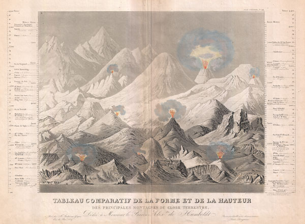
Tableau comparatif de la forme et de la hauteur des principales montagnes du globe terrestre, dedie a Monsieur le Baron, Alexdre. de Humboldt.
1850 (Undated) 17 x 22 in (43.18 x 55.88 cm)
1850 (Undated) 17 x 22 in (43.18 x 55.88 cm)
Description
An exceptionally attractive and unusual 1850 comparative mountains chart by Andriveau-Goujon. A fine mid-century example of the comparative chart convention. Shows many of the world's greatest mountains and volcanoes in proximity to one other such that we can compare and contrast not only their heights, but also their forms. Illustrates eight volcanoes shooting flames into the air. Dhaulagiri, in the Nepali Himalayas is identified as the world's greatest peak. The names and elevations of the various other peaks shown are identified textually to either side of the chart proper. In the lower quadrants of the chart some subterranean distances are shown, most specifically the Mines of Anxin. Title area at the base of the map includes Andriveau-Goujon's dedication of this chart to Alexander von Humboldt, who's early 19th century work inspired the entire comparative geological chart genre. Drawn c. 1850 by Ambroise Tardieu for inclusion as plate 44 in Andriveau-Goujon's Atlas Universal.
CartographerS
Eugène Andriveau-Goujon (1832 - 1897) was a map publisher and cartographer active in 19th century Paris. The firm was created in 1825 when Eugène Andriveau married the daughter of map publisher Jean Goujon - thus creating Andriveau-Goujon. Maps by Andriveau-Goujon are often confusing to identify as they can be alternately singed J. Goujon, J. Andriveau, J. Andriveau-Goujon, E. Andriveau-Goujon, or simply Andriveau-Goujon. This refers to the multiple generations of the Andriveau-Goujon dynasty and the tendency to republish older material without updating the imprint. The earliest maps to have the Andriveau-Goujon imprint were released by Jean Andriveau-Goujon. He passed the business to his son Gilbert-Gabriel Andriveau-Goujon, who in 1858 passed to his son, Eugène Andriveau-Goujon, under whose management the firm was most prolific. Andriveau-Goujon published numerous fine pocket maps and atlases throughout the 19th century and often worked with other prominent French cartographers of the time such as Brue and Levasseur. The firm's stock was acquired by M. Barrère in 1892. More by this mapmaker...
Ambroise Tardieu (March 2, 1788 - January 17, 1841) was a prominent French cartographer and engraver operating in the late 18th and early 19th centuries. He was member of the large and prolific Tardieu family, which, for over 200 years, produced multiple skilled and active engravers. Tardieu's work is known for its beauty and accuracy as well as for its depth of detail. Tardieu's most important work is his version of John Arrowsmith's large format map of the United States, published in 1806. Ambroise Tardieu is eclipsed in fame by his son, artist and medical scholar, August Ambroise Tardieu. Ambroise Tardieu is also frequently confused with Jean Baptiste Pierre Tardieu, another unrelated French map and print engraver active in the early 19th century. Learn More...
Source
Andriveau, J. and Goujon, J., Atlas classique et universel de geographie ancienne et moderne, contenant les decouvertes et les divisions les plus nouvelles dans les cinq parties du monde pour servir a la lecture des voyages, des ouvrages historiques et des meilleurs traites de geographie, 1850.
Condition
Very good. Minor verso reinforcement and toning along original centerfold. Else clean.
References
Rumsey 2486.043. Phillips (Atlases) 791-44.