This item has been sold, but you can get on the Waitlist to be notified if another example becomes available, or purchase a digital scan.
1806 Cary Map of Florida, Georgia, North Carolina, South Carolina and Tennessee
NCSCGAFL-cary-1806$550.00

Title
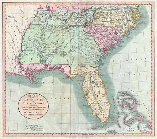
A New Map of Part of the United States of North America, Containing the Carolinas and Georgia, also the Floridas and Part of the Bahama Islands etc.
1806 (dated) 18.5 x 20.5 in (46.99 x 52.07 cm)
1806 (dated) 18.5 x 20.5 in (46.99 x 52.07 cm)
Description
Published by John Cary in 1805, this is one of the most interesting and attractive maps of the American southeast to appear in the first years of the 19th century. Covers from Kentucky and Virginia South include all of modern day North Carolina, South Carolina, Tennessee, Georgia, Alabama, Mississippi and Florida. Georgia is shown extending westward as far as the Mississippi River despite the creation of the Mississippi Territory in 1798. Florida is divided at the Appalachicola River into eastern and western sections. West Florida, ostensibly part of the Louisiana Purchase, was claimed by the Spanish and remained under their control until 1812. Southern Florida is labeled 'Ancient Tegesta' according to the 18th century convention. Tegesta is a name of somewhat mysterious origins that appears on maps of Florida as early as the 1600s. It most likely refers to a vanished American Indian tribe or abandoned village located near what is today Miami. Offers copious notations and comments throughout, most of which are extremely interesting. Identifies the locations of numerous American Indian nations including the Creeks, the Chicksaw Nation, the Cherokees and others. Notes the abandoned Applachee Villages in northern Florida. Also offers notes on American Indian hunting grounds, springs, river navigation, roads, swamps, forts and the sites of important battles. All-in-all a wonderful example of a rare and important map of the American southeast. Prepared in 1806 by John Cary for issue in his magnificent 1808 New Universal Atlas.
Cartographer
John Cary (1754 - 1835) was a London based cartographer active in the early part of the 19th century. Ronald Vere Tooley, the prominent English map historian, writes of Cary, "As an engraver he was elegant and exact with fine clear lettering and great delicacy of touch." Cary began his work as an engraver, cartographer, and globe maker in 1776 with his New and Correct English Atlas. This important atlas represented a new phase in cartography where accuracy and detail rose in prominence over the decorative embellishments of the 18th century. This change was indicative of the times when travel and commerce were expanding globally as never before. Cary's mastery of both engraving and cartography resulted in a series of seminal works that redefined mapmaking in the early 19th century. His stupendous Cary's New Universal Atlas, published in 1808, set the standard for all cartographers who followed. Cary reissued this seminal atlas in 1811, 1819, 1824, 1828, 1833, 1836 and 1844. Cary also did considerable work on the English Ordinance Survey prior to 1805. His cartographic work particularly inspired the Edinburgh school of cartography as represented by John Pinkerton and John Thomson. In America, Cary's work was used as the basis for Tanner's important New American Atlas. Cary's last published atlas appeared posthumously in 1844, however, by 1850 Cary's work was being carried on by his sons and other well-known cartographers including James Wyld, John Tallis & Company, and Crutchley. More by this mapmaker...
Source
Cary, John, Cary's New Universal Atlas, containing distinct maps of all the principal states and kingdoms throughout the World. From the latest and best authorities extant. London: Printed for J. Cary, Engraver and Map-seller, No. 181, near Norfolk Street, Strand, 1808.
Condition
Very good condition. Minor discoloration in Gulf of Mexico and near 'Akenfonogo Swamp', else clean. Original centerfold. Blank on veso.
References
Rumsey, 1657.059. Fitzgerald, J.H. Changing perceptions: mapping the shape of Florida 1502-1982, 118. Phillips, P. L., A List of Maps of America in the American Library of Congress, p. 876. Universty of Georgia, Hargrett Library, Map 1813 M4. University of North Carolina at Chapel Hill, Cm912 1806c1.