
War Route Maps
Building Bridges from Normandy to the Elbe.
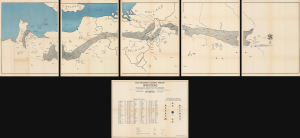
Operations from Omaha Beach to Elbe River.
$3,500.00
Acquire
- Digital Map Information
- Suitable for large format printing
- Full resolution TIFF file
- ICC color profile embedded
- Delivered instantly via download link
This monumental 1945 John A. LeDonne route map chronicles the 1115th Engineer Combat Group's advance across Europe during the final year of World War II (1939 - 1945). Among the largest and most elaborate American unit route maps, it follows the 1115th from Normandy through France, Belgium, and Holland and deep into Germany to the Elbe, recording command posts, dates, movements, and an extraordinary 100 bridge-building operations along the way. Punctuated by humorous and sometimes risqué pictorial vignettes recalling liberation, alcohol, romance, and the everyday experiences of American soldiers abroad, the map is at once a remarkable operational record and a vivid visual memoir of the 1115th's war across Europe. (more details)
Cyanotype World War II route map!
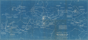
Graphical History of the 987th F.A. Battalion 155 MM Self Propelled Guns. Lt. Col. Wm. C. Smith, BN CO.
$2,500.00
Acquire
- Digital Map Information
- Suitable for large format printing
- DPI: 600
- File Size: 42.67 MB
- File Type: ZIP / TIFF
- ICC color profile embedded
- Delivered instantly via download link
This is a rare 1946 cyanotype World War II route map of the 987th Field Artillery Battalion in Europe, drawn by the battalion's commanding officer, Lieutenant Colonel William C. Smith. The map highlights moments throughout the 987th's campaign across Europe and provides snippets of the battalion's experiences in the war. This map is the only cyanotype route map we have encountered. Due to restrictions imposed by the cyanotyping process, this map was likely produced in a very small print run. (more details)
A complete set of 79th Infantry Division route maps from World War II - maps created by the soldiers for the soldiers.
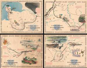
Through France with the 79th Infantry Division 14 June to 29 Aug, 1944. Maj Gen I.T. Wyche, Commanding. / To Belgium and Back wit the 79th Infantry Division 31 Aug to 25 Oct, 1944 Maj. Gen. I. T. Wyche, Commanding. / To the Rhine with the 79th Infantry Division 25 Oct to 14 Feb. 1945 Maj Gen I.T. Wyche, Commanding. / Over the Rhine with the 79th Infantry Division 17 Feb to 9 May 1945 Maj. Gen. I. T. Wyche, Commanding.
$2,200.00
Acquire
- Digital Map Information
- Suitable for large format printing
- Full resolution TIFF file
- ICC color profile embedded
- Delivered instantly via download link
This is a set of four Steve Kaliher and Harry D. White pictorial World War II route maps of the 79th Infantry's advance from Normandy to Germany. Presented on four separate sheets, a detailed summary of the division's progress across northern Europe from Utah Beach (one of the four Normandy beaches assaulted by Allied troops only eight days on what has become known as D-Day) to Mulheim, Germany. Each map traces a sequence of a few months in the combat history of the 79th with red lines labeled with dates marking the advance week by week and sometimes day to day. Text blocks narrate parts of the advance, providing insight into what the division accomplished during their over 300 days of combat. Cities and towns are identified throughout all four maps, as are rivers. Each map is framed by the names of cities and towns that the division passed through on their advance, fought for, and liberated, adding yet another level of memory to each piece. (more details)
Follows the 36th Infantry from Salerno to Austria.
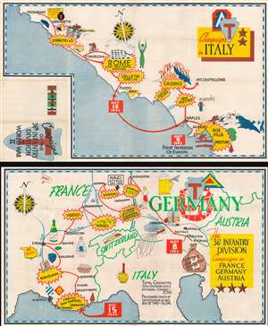
Campaigns of the 36th Infantry Division in World War II. Campaigns in Italy. The 36th Infantry Division Campaigns in France Germany Austria.
$1,400.00
Acquire
- Digital Map Information
- Suitable for large format printing
- Full resolution TIFF file
- ICC color profile embedded
- Delivered instantly via download link
This is a set of two 1945 World War II pictorial route maps of Italy, France, Germany, and Austria following the 36th Infantry Division's progress during the conflict. Yellow and red bursts mark important battles, including Salerno, Rome, Vesoul, and Hagenau. Other pictorial elements reference life encountered along the way, such as children asking for chocolate and the wonder of French champagne. (more details)
One of the few route maps published during rather than after WWII.
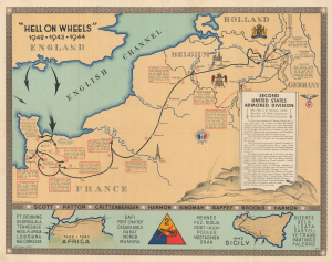
'Hell on Wheels' 1942 - 1943 - 1944. Second United States Armored Division.
$1,200.00
Acquire
- Digital Map Information
- Suitable for large format printing
- File Size: 35.09 MB
- File Type: ZIP / TIFF
- ICC color profile embedded
- Delivered instantly via download link
This is the 1944/45 Marion E. Baker World War II Second Armored Division Pictorial Route Map of Europe. Unlike most WWII Route Maps, the present map was published during the war, making it part of the war experience rather than a post-war summary. One is also struck by the extent of the Second Armored Division's campaigning, stretching to include North Africa, Sicily, and western Europe. (more details)
Ephemeral WWII mimeograph Route Map following the 318th Infantry Regiment.
Map Route CT 318.
$1,000.00
Acquire
- Digital Map Information
- Suitable for large format printing
- Full resolution TIFF file
- ICC color profile embedded
- Delivered instantly via download link
This is a 1945 mimeographed World War II unit route map of the 318th Infantry Regiment in Europe. It records the regiment's fight across Europe, noting milestones, and includes an operational report of the last days of combat in the European theatre, May 6-7, 1945, on the verso. As a mimeograph, this route map is unusual for the genre and limited by the medium, making it exceptionally ephemeral. (more details)
Evacuation hospital during World War II.
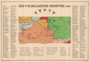
103rd Evacuation Hospital (SM).
$1,000.00
Acquire
- Digital Map Information
- Suitable for large format printing
- File Size: 22.07 MB
- File Type: ZIP / TIFF
- ICC color profile embedded
- Delivered instantly via download link
This is a rare 1945 World War II route map of the 103rd Evacuation Hospital in the European Theater of Operations - the only map was are aware of to detail a medical unit. One of only two known examples, this map provides an overview of the medical unit's wartime activities. We have been unable to locate a corresponding unit history for the 103rd Evacuation Hospital, making this map a critical piece of the broader history of World War II. (more details)
Unique insights into WWII Route Maps.
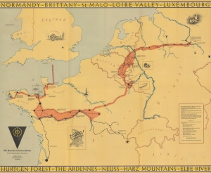
83d United States Infantry Division. The Thunderbolt Division. The Thunderbolt Across Europe.
$1,000.00
Acquire
- Digital Map Information
- Suitable for large format printing
- Full resolution TIFF file
- ICC color profile embedded
- Delivered instantly via download link
This is a 1945 83rd Infantry Division Information-Education Section World War II pictorial route map of Western Europe accompanied by a letter from General Robert Macon, the commanding officer of the 83rd Infantry Division. The letter offers unique insight into the production of this, and other, similar WWII route maps. (more details)
Personal insights into the 301st Field Artillery during World War I.
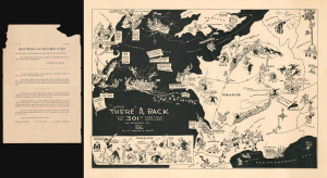
Over There' and Back with the 301st First Field Artillery.
$800.00
Acquire
- Digital Map Information
- Suitable for large format printing
- Full resolution TIFF file
- ICC color profile embedded
- Delivered instantly via download link
This rare 1933 Lewis Rothe and Warren Gibbs pictorial map of Europe playfully commemorates the peregrinations of the 301st Field Artillery during World War I (1914 - 1918). The map traces the 301st's movements from Boston through Nova Scotia and England to France, then back across the Atlantic to New York City after the war ended. Lewis Rothe drew the map in collaboration with Warren R. Gibbs, a veteran of the 301st. A series of 'close-ups' in the lower left offers interesting personal insights into the unit: Lieutenant Dowd's luck at gambling and Colonel Brooke's habit of buying souvenirs. (more details)
Tank Destroyers during World War II.
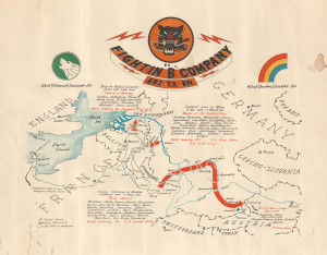
Fightin' 'B' Company 692 T.D. Bn.
$800.00
Acquire
- Digital Map Information
- Suitable for large format printing
- File Size: 16.83 MB
- File Type: ZIP / TIFF
- ICC color profile embedded
- Delivered instantly via download link
This is a c. 1945 World War II unit route map of Company B, 692nd Tank Destroyer Battalion, in Europe. The map follows Company B from its September 26, 1944, debarkation in Europe through France, Belgium, and Germany until May 8, 1945, V-E Day, the end of the war in Europe. (more details)
The 188th from England to victory in Germany.
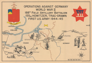
Operations Against Germany World War II 188th Field Artillery Battalion 155mm Howitzer, Trac-Drawn First U.S. Army 1944 - 45.
$750.00
Acquire
- Digital Map Information
- Suitable for large format printing
- Full resolution TIFF file
- ICC color profile embedded
- Delivered instantly via download link
This is a 1945 188th Field Artillery Battalion World War II Route Map of Europe. The map traces the battalion's movements during the war, marking important events and providing comedic commentary on the experience. (more details)
Employs a rainbow to trace the route of the 42nd Infantry 'Rainbow' Division through Europe during World War II.
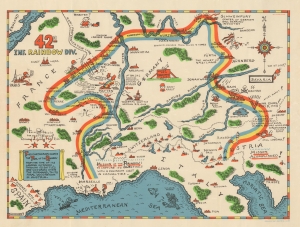
42nd Inf. Rainbow Div.
$750.00
Acquire
- Digital Map Information
- Suitable for large format printing
- File Size: 15.46 MB
- File Type: ZIP / TIFF
- ICC color profile embedded
- Delivered instantly via download link
Created by Theodore MacKechnie, a veteran of the 42nd Infantry Division, this 1945 pictorial route map traces the path of the 42nd from its landing at Marseille on December 9th, 1944, until its arrival Austria in Austria after serving 106 days in combat. A wonderfully comic depiction of an incredibly serious subject, MacKechnie used the division's nickname, 'Rainbow', to inspire his depiction of their route across Europe. (more details)
84th Infantry Division's during World War II.
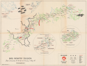
84th Infantry Division From Activation 15 Oct 42 to V-E Day 9 May 45.
$550.00
Acquire
- Digital Map Information
- Suitable for large format printing
- Full resolution TIFF file
- ICC color profile embedded
- Delivered instantly via download link
This is a 1945 George D. Harney World War II campaign route map chronicling the movements of the U.S. Army's 84th Infantry Division across Europe. This map is distinct within the genre as Harney eschews extraneous geographical detail, focusing attention on the places where he and his comrades traveled and fought. The central map traces the division's principal campaign route, while three insets document its deployment and actions in key combat zones. (more details)
Illustrates the advance of the 79th Infantry Division across eastern France.
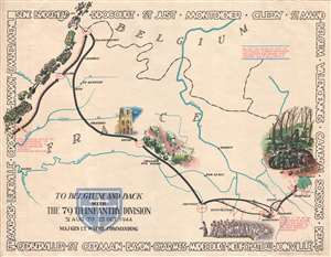
To Belgium and Back with the 79th Infantry Division 31 Aug to 25 Oct, 1944.
$550.00
Acquire
- Digital Map Information
- Suitable for large format printing
- File Size: 12.37 MB
- File Type: ZIP / TIFF
- ICC color profile embedded
- Delivered instantly via download link
This is a 1945 Steve Kaliher and Harry D. White pictorial map of the 79th Infantry Division's route through eastern France from north of Paris near the Oise River to the Parroy Forest. The second in a series of four maps depicting the division's advance through Europe after the Allied invasion, this map follows the division's movements from August 31 until October 25, 1944, when the division was pulled off the combat line for rest and training. Solid black arrows trace the division's progress, with red lettering indicating the date (or dates) spent in a specific location. (more details)
Follow the 186th from Omaha Beach to Czechoslovakia.
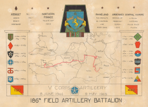
V Corps Artillery. 8 June 1944 - 9 May 1945. 186th Field Artillery Battalion.
$500.00
Acquire
- Digital Map Information
- Suitable for large format printing
- File Size: 11.14 MB
- File Type: ZIP / TIFF
- ICC color profile embedded
- Delivered instantly via download link
This is a 1945 World War II route map of the 186th Field Artillery Battalion in Europe. A striking visual summary of the battalion's war in Europe, this map follows the 186th from landing on Omaha Beach to Pilsen, Czechoslovakia, where they were when the war ended. It also chronicles the battalion's support of 12 divisions while fighting across Europe and notes its five battle stars. (more details)
Thematic map illustrating the events of the WWII Philippines Campaign of 1945.
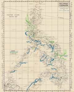
Philippine Campaign. Philippine Islands Sketch Map.
$450.00
Acquire
- Digital Map Information
- Suitable for large format printing
- File Size: 13.92 MB
- File Type: ZIP / TIFF
- ICC color profile embedded
- Delivered instantly via download link
This is an unusual 1945 thematic map of the Philippine Islands illustrating the events of the Philippine Campaign (1944 - 1945) during World War II. It is related to other World War II era unit route maps, but, given the differences in geography between the Philippine Archipelago and Western Europe, the movements of the Sixth Army and the Eighth Army are illustrated in a much different way. (more details)
87th Infantry Division during World War II.
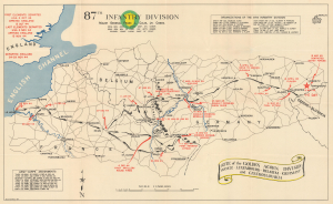
87th Infantry Division. Route of the Golden Acorn Division France, Luxembourg, Belgium, Germany, and Czechoslovakia.
$425.00
Acquire
- Digital Map Information
- Suitable for large format printing
- Full resolution TIFF file
- ICC color profile embedded
- Delivered instantly via download link
This is a 1945 campaign route map for the 87th Infantry Division in western and central Europe during World War II. The map was issued as a souvenir campaign map in the immediate wake of WWII to chronicle the Division's movements and battles from its arrival at Le Havre, France, until V-E Day near the Czechoslovak border. (more details)
WWII 13th Armored Division: from Le Havre, France, to Austria.
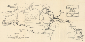
13th Armored (Black Cat) Division. A History in Pictures Jan-May 1945.
$400.00
Acquire
- Digital Map Information
- Suitable for large format printing
- Full resolution TIFF file
- ICC color profile embedded
- Delivered instantly via download link
This is a 1945 World War II (1939 - 1945) pictorial unit route map drawn by Technician Fourth Grade Wendell Lovett, a member of the 13th Armored Division. The map highlights the division's deployment in Europe from January 1945 until the end of the war in May 1945. Small illustrations of tanks are scattered throughout, underlining the division's role as an armored unit. It was published in June 1945 in Europe before the 13th Armored Division returned to the United States. (more details)
Follow the U.S.S. Lexington through three years of the Pacific War.
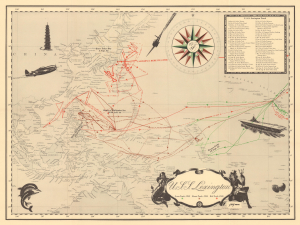
U.S.S. Lexington.
$400.00
Acquire
- Digital Map Information
- Suitable for large format printing
- Full resolution TIFF file
- ICC color profile embedded
- Delivered instantly via download link
This 1945 World War II route map of the U.S.S. Lexington focuses on the theater rarely addressed in the route map genre: the Pacific War. Most World War II route maps focus on the European Theater, but this piece follows the aircraft carrier U.S.S. Lexington in the Pacific theater from 1943-1945. It highlights battles and traces the Lexington's movements in detail, offering a day-by-day account of the aircraft carrier's campaigns. (more details)
1st U.S. Army from D-Day to V-E Day.
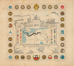
Operations of the First United States Army in Europe June 6, 1944 to May 9, 1945.
$400.00
Acquire
- Digital Map Information
- Suitable for large format printing
- File Size: 18.93 MB
- File Type: ZIP / TIFF
- ICC color profile embedded
- Delivered instantly via download link
This is a 1945 Einar Larssen pictorial World War II route map of the First United States Army in Europe. The map traces the path of the First Army as it traveled throughout Europe. It is one of the more overtly decorative pieces in the genre. (more details)
The Cactus Division as it fights its way through France, Germany, and Austria.
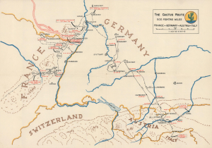
The Cactus Route. 500 Fighting Miles. France-Germany-Austria-Italy
$350.00
Acquire
- Digital Map Information
- Suitable for large format printing
- Full resolution TIFF file
- ICC color profile embedded
- Delivered instantly via download link
This is a 1945 World War II unit route map of the 103rd Infantry Division from France, through Germany, Austria, and Italy. It highlights battles, defensive positions, and occupation duties from November 1944 until May 1945. (more details)