This item has been sold, but you can get on the Waitlist to be notified if another example becomes available, or purchase a digital scan.
1850 Mitchell Map of New York City
NewYorkCity-mitchell-1850$225.00

Title
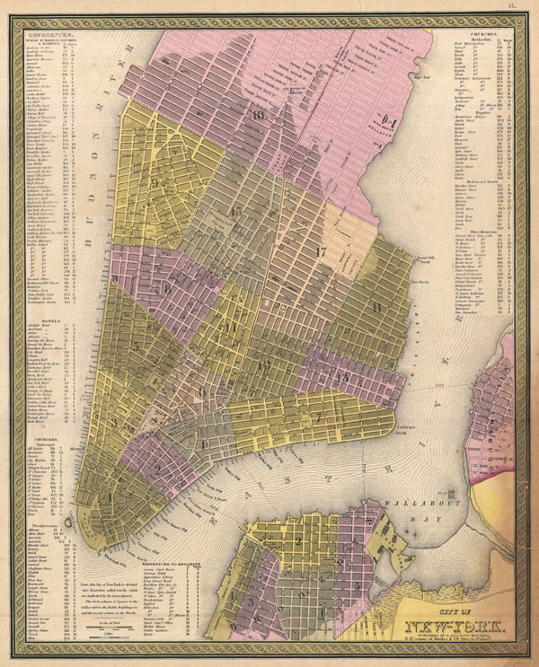
City of New-York.
1850 (undated) 15.75 x 12.5 in (40.005 x 31.75 cm)
1850 (undated) 15.75 x 12.5 in (40.005 x 31.75 cm)
Description
This hand colored map of New York City is a lithograph engraving, dating to 1850 by the American mapmaker S.A. Mitchell Sr. The map epicts the island of Manhattan from 37th street (Kips Bay) south to Battery Park and Brooklyn from Williamsburg to Columbia St. The whole is shown in magnificent detail with many important buildings, ranging from the Brooklyn Naval Yard to important hotels and churches, depicted and labeled. One of the most visually appealing maps of New York City to emerge from the workshops of a mid-19th century American cartographer.
Cartographer
Samuel Augustus Mitchell (March 20, 1792 - December 20, 1868) began his map publishing career in the early 1830s. Mitchell was born in Bristol, Connecticut. He relocated to Philadelphia in 1821. Having worked as a school teacher and a geographical writer, Mitchell was frustrated with the low quality and inaccuracy of school texts of the period. His first maps were an attempt to rectify this problem. In the next 20 years Mitchell would become the most prominent American map publisher of the mid-19th century. Mitchell worked with prominent engravers J. H. Young, H. S. Tanner, and H. N. Burroughs before attaining the full copyright on his maps in 1847. In 1849 Mitchell either partnered with or sold his plates to Thomas, Cowperthwait and Company who continued to publish the Mitchell's Universal Atlas. By about 1856 most of the Mitchell plates and copyrights were acquired by Charles Desilver who continued to publish the maps, many with modified borders and color schemes, until Mitchell's son, Samuel Augustus Mitchell Junior, entered the picture. In 1859, S.A. Mitchell Jr. purchased most of the plates back from Desilver and introduced his own floral motif border. From 1860 on, he published his own editions of the New General Atlas. The younger Mitchell became as prominent as his father, publishing maps and atlases until 1887, when most of the copyrights were again sold and the Mitchell firm closed its doors for the final time. More by this mapmaker...
Source
Mitchell Sr., S. A.,A New Universal Atlas Containing Maps of the various Empires, Kingdoms, States and Republics Of The World. (1850 issue)
Condition
Very good condition. Blank on verso. Minor toning in the lower right quadrant - see image. A few marginal verso repairs of closed tears. Else a clean example.
References
Rumsey 0537.012. Phillips (Atlases) 6103-11. Haskell, D. C., Manhattan Maps: A Co-operative List, 901.