This item has been sold, but you can get on the Waitlist to be notified if another example becomes available, or purchase a digital scan.
1768 Holland - Jeffreys Map of New York and New Jersey (First Edition)
NewYorkNewJersey-sayer-1768$3,150.00

Title
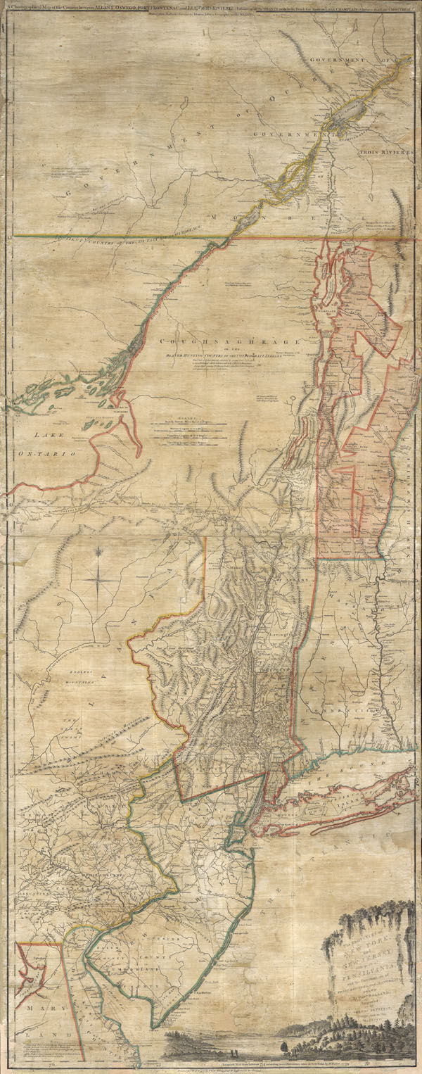
The Provinces of NEW YORK and NEW JERSEY with part of PENSILVANIA, and the Governments of TROIS RIVIERES, and MONTREAL: drawn by Capt. Holland. / A Chorographical Map of the Country between Albany, Oswego, Fort Frontenac, and Les Trois Rivieres; Exhibing all the Grands made by the French Governors on Lake Champlain; & between that Lake & Montreal.
1768 (undated) 53 x 21 in (134.62 x 53.34 cm)
1768 (undated) 53 x 21 in (134.62 x 53.34 cm)
Description
A first issue first edition example of a seminal map. This is a rare and unusual version of the 1768 first edition of Holland and Jefferys seminal map of New York and New Jersey. Depicts the important trade corridor between New York and Montreal, specifically detailing from Delaware Bay northward including parts of eastern Pennsylvania, New Jersey, Long Island, New York Connecticut, Massachusetts and Vermont as well as the Iroquois League, the Trois Rivieres territories and Montreal, as far as Lac St. Pierre in modern day Quebec. Lower right quadrant features a pictorial title cartouche showing the Hudson River.
This extraordinary map is unusual on many levels in addition to its status as the first edition first state of an extremely rare and important map. Unlike most examples, this map is in an independent issue and has no suggestion that it may have been bound into an atlas. Instead it is linen backed in wall map format. Secondly, though most examples of this map, even other first editions, show the New York-New Jersey border much where it is today, our example was colorized to show the line running considerably south of its currently location – a rarity which can be seen in only three other known examples. While we would not describe this as a different state, as the essential engraving is the same as was used in other 1868 editions, the difference in coloration is fascinating, unusual, and bears attention. This requires a bit of explanation:
Much of the cartography for this map was derived from the work of surveyor Samuel Holland produced in his roles as New York – New Jersey boundary commissioner and later as 'Surveyor of the Northern District' for the Board of Trade which governed the crown colonies in America. As this map was being prepared a fierce legal battle raged between the colonies of New York and New Jersey regarding the position of their western border.
The dispute between the New York and New Jersey regarding their western border was long standing and complex. New Jersey contended that its northern border accorded with the findings of a survey issued in 1719, which extended the border northward as far as Station Point, well north of the current line. New York, on the other hand, contended for a southerly border based upon surveys performed in 1686. The Board of Trade commissioned Samuel Holland to create a map of this disputed region. Holland's work resulted in a manuscript map , now lost, that was submitted to the Board of Trade in England. Holland, who favored New York, argued that the original crown charter defining the New York and New Jersey border was based upon intersecting lines referencing a branching of the Delaware River and the old divide between East and West Jersey. This would put much of what is today northern New Jersey firmly in New York. The dispute was finally settled in 1768 by agreement to a compromised line roughly where it stands today – note 1768 is the same year that Jefferys engraved this map.
In his role as Geographer to the King, Jefferys would have had access to the Holland maps which were prepared for the Board of Trade and sent to London. It is likely that Jefferys used these materials, along with the works of Evans and Colden to compile this much grander map. As the official Royal Geographer, Jefferys would not have been required to ask permission to use any of these materials and indeed, as Powell suggests, it is likely that the 'Name of Capt. Holland is put, without his Knowledge or Consent.'
Most likely, Jefferys ordered the peculiar coloration of this map, which follows the southern border NY-NJ border following recommendations in Holland's notes. Holland advocated for the southerly border that we see colorized here. Probably this is a preliminary state of the map, printed sometime early in 1768, before the compromise boundary was formalized. We have been able to identify only three other examples of this map with the same New York-New Jersey border coloration. One example rests in the Library at Harvard University, another is located in the New York Public Library in New York, and a final example in the New York State Library in Albany. Other examples of the first edition, including those held by the Library of Congress follow the line of the 1868 compromised border.
Holland's work is also evident in the detailing of New York's land grants to Vermont and the excellent detail offered in the Albany area.
Notes forts and military installations along the Hudson and elsewhere. Though surprisingly accurate in reference to the heavily populated part of New York and New Jersey, accuracy falls off considerably in the west and in the American Indian regions to the North. Jefferys also notes the influence of other cartographers including Evans, Bond, Morris, and of course Holland.
In the years to follow this important map would go through several subsequent revisions and reissues. The most notable later version is the 1775 Sayer and Bennett atlas issue of the map, which is somewhat common. Our issue, the first state of the 1768 first edition, has not appeared on the market in the last 30 years.
The original owner of this map, whose bookplate is on the verso, appears to have been William Lyon of New Haven Connecticut. In 1775 Lyon was a Lieutenant in the Continental Army who is recorded as serving in Boston. A gravestone near New Haven Connecticut bears his name and the rank of colonel. It is conceivable that Lyon examined this very map to plan strategies during his time of service with the Continental Army during the American Revolutionary War.
CartographerS
Samuel Holland (1728 - December 28, 1801) was a surveyor and cartographer of extraordinary skill and dedication. Holland was born in the Netherlands in 1728 and, at 17, joined the Dutch Army where he attained the rank of Lieutenant. Around 1754 Holland emigrated to England where he joined the newly forming Royal American Regiment. His skills as a cartographer and surveyor brought him to the attention of his superiors who offered him steady promotions. In 1760 he prepared an important survey of the St. Lawrence River system. It was during this survey that Holland met a young James Cook, who he mentored in the art of surveying. Cook, best known for his exploration of the Pacific, developed many of his own revolutionary nautical surveying techniques based the systems he learnt from Holland. In 1762 Holland caught the attention of the Commission of Trade and Plantations, who governed the British Crown Colonies in America. Under the umbrella of the Trade Commission Holland prepared surveys of the Hudson River Valley and other New York properties. In 1764 he was named Surveyor General for the Northern District, the position in which he did much of his most important work. Holland is also known for surveying done in an attempt to sort out the New York - New Jersey border conflict. Following his work in New York Holland relocated to Canada where, with his new wife of just 21 years, he sired seven children. Like many early surveyors working for colonial governments, Holland was poorly compensated and is known to have supplemented his income by selling the results of his surveys, and those of other surveyors to which he had privileged access, to private publishers, among them the London firm of Laurie and Whittle, who published his work under the pseudonym of 'Captain N. Holland.' Samuel Holland died in Quebec in 1801. More by this mapmaker...
Thomas Jefferys (1695 - November 20, 1771) was one of the most prominent and prolific map publishers and engravers of his day. Jefferys was born in Birmingham and was apprenticed to the engraver Emmanuel Bowen in 1735. Later, in the 1740s he engraved several maps for the popular periodical Gentleman's Magazine. Around 1740 Jefferys was finally able to go into business for himself and in 1746 received an appointment as 'Geographer to Fredrick, Prince of Wales,' which shortly after translated to the position of 'Royal Cartographer to King George III.' Jefferys initially specialized in compiling and re-engraving the works of earlier cartographers into more coherent cartographic wholes. Later, while not salaried position, Jefferys' appointment as 'Royal Cartographer' guaranteed preferential access to the most up to date cartographic material available, allowing him to produce new and updated charts of exceptional accuracy. He his best known for his maps of the Americas, particularly the posthumously published 1775 American Atlas, which included some of the finest and most important late colonial era maps of America ever made. Despite his prolific publishing history, royal appointments, and international publishing fame, Jefferys lived most of his life in dire economic straits. He was bailed out of bankruptcy by Robert Sayer during the production of the American Atlas. In the end, Jefferys died suddenly with very little to his name. Nonetheless, his cartographic legacy survived, and even after his death in 1771, many of his important maps continued to be published and republished by Sayer and Bennet, Conrad Lotter, Georges Louis Le Rouge, Laurie and Whittle, and others. Many attribute some of Jefferys best maps to the colorful and criminally inclined Irish cartographic genius Braddock Mead (John Green, c. 1688 - 1757), who is considered the 'secret behind Jefferys.' Jefferys was succeeded by his son, also Thomas, who had little success as a cartographer and eventually partnered with, then sold his stock and plates to William Faden - Jefferys' true heir. Learn More...
Robert Sayer (1725 - January 29, 1794) was an important English map publisher and engraver active from the mid to late 18th century. Sayer was born in Sunderland, England, in 1725. He may have clerked as a young man with the Bank of England, but this is unclear. His brother, James Sayer, married Mary Overton, daughter-in-law of John Overton and widow of Philip Overton. Sayer initially worked under Mary Overton, but by December of 1748 was managing the Overton enterprise and gradually took it over, transitioning the plates to his own name. When Thomas Jefferys went bankrupt in 1766, Sayer offered financial assistance to help him stay in business and, in this way, acquired rights to many of the important Jefferys map plates as well as his unpublished research. From about 1774, he began publishing with his apprentice, John Bennett (fl. 1770 - 1784), as Sayer and Bennett, but the partnership was not formalized until 1777. Bennett retired in 1784 following a mental collapse and the imprint reverted to Robert Sayer. From 1790, Sayer added Robert Laurie and James Whittle to his enterprise, renaming the firm Robert Sayer and Company. Ultimately, Laurie and Whittle partnered to take over his firm. Sayer retired to Bath, where, after a long illness, he died. During most of his career, Sayer was based at 53 Fleet Street, London. His work is particularly significant for its publication of many British maps relating to the American Revolutionary War. Unlike many map makers of his generation, Sayer was a good businessman and left a personal fortune and great estate to his son, James Sayer, who never worked in the publishing business. Learn More...
Source
Seems to be an independent issue, though a similar example appears in Thomas Jeffery's General Topography of North America and the West Indies, 1768.
Condition
Full professional restoration. Original sailcloth backing replaced with contemporary linen.
References
Allen, David Y., 'Comparing Eighteenth-Century Map of New York State Using Digital Imagery', http://www.nymapsociety.org/FEATURES/ALLEN.HTM. Schwarz, Philip J., The Jarring Interests New York's Boundary Makers, 1664-1776 p. 133 - 190. Tooley, R. V. The Mapping of America, #44. Library of Congress, G3800 1768 .H6 Vault (1868 edition). New York Public Library, Map Div. 97-6176 [LHS 815], Map Div. 01-5334 (similar NJ-NY border). Phillips, Maps of America, p. 502; Phillips 1196. McCorkle (#768.3, 775.6, 776.13). Sellers & van Ee (#1039-40, 1042-43, 1045-46). Ristow, Walter W., American Maps and Mapmakers, page 52.