
This item below is out of stock, but another example (left) is available. To view the available item, click "Details."
Details
1771 Bonne Map of the Hudson Bay, Canada
1771 (dated) $500.00
1776 Bonne Map of Louisiana and the British Colonies in North America
NorthAmericaEast-bonne-1776$300.00

Title
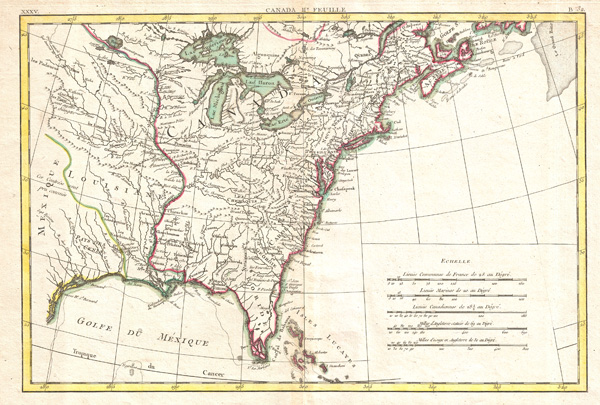
Partie De L'Amerique septentrionale, qui comprend le Canada, La Louisiane, Le Labrador, Le Greenland, La Nouvelle Angleterre, La Floride & C.
1776 (undated) 12.5 x 18 in (31.75 x 45.72 cm)
1776 (undated) 12.5 x 18 in (31.75 x 45.72 cm)
Description
Printed in 1776, on the cusp of the American Revolutionary War, this is Bonne's important map of Louisiana and the British claims in North America. Covers from the Grand Banks south to Florida and westward as far as Mexico and Texas. Shows the British holdings in America at their fullest extent. Following the French and Indian War, the British laid claims to all of Canada and the entire Great Lakes region. France maintained its hold on the territory west of the Mississippi River to New Mexico. This map is extremely rich in detail offering and naming countless American Indian settlements and villages. Also names a number of early French forts and trading posts along the Missouri and other westward tributaries of the Mississippi. The Great Lakes are laid out with a close approximation of accuracy though several apocryphal islands are shown in Lake Superior. A red line just north of the great lakes marks the southernmost boundary to the lands claimed by the Hudson Bay Company. Southern Florida is drawn as an archipelago in an early attempt to depict the Everglades. Names Niagara Falls as well as numerous French forts along the Mississippi and further west.
Bonne also issued a slightly earlier edition of this map in 1771 joined to an associated map of what is today eastern Canada. Drawn by R. Bonne in 1776 for issue as plate no. A 32 in Jean Lattre's 1776 issue of the Atlas Moderne.
Bonne also issued a slightly earlier edition of this map in 1771 joined to an associated map of what is today eastern Canada. Drawn by R. Bonne in 1776 for issue as plate no. A 32 in Jean Lattre's 1776 issue of the Atlas Moderne.
CartographerS
Rigobert Bonne (October 6, 1727 - September 2, 1794) was one of the most important French cartographers of the late 18th century. Bonne was born in Ardennes à Raucourt, France. He taught himself mathematics and by eighteen was a working engineer. During the War of the Austrian Succession (1740 - 1748) he served as a military engineer at Berg-op-Zoom. It the subsequent years Bonne became one of the most respected masters of mathematics, physics, and geography in Paris. In 1773, Bonne succeeded Jacques-Nicolas Bellin as Royal Cartographer to France in the office of the Hydrographer at the Depôt de la Marine. Working in his official capacity, Bonne compiled some of the most detailed and accurate maps of the period - most on an equal-area projection known erroneously as the 'Bonne Projection.' Bonne's work represents an important step in the evolution of the cartographic ideology away from the decorative work of the 17th and early 18th century towards a more scientific and practical aesthetic. While mostly focusing on coastal regions, the work of Bonne is highly regarded for its detail, historical importance, and overall aesthetic appeal. Bonne died of edema in 1794, but his son Charles-Marie Rigobert Bonne continued to publish his work well after his death. More by this mapmaker...
Jean Lattré (170x - 178x) was a Paris based bookseller, engraver, globe maker, calligrapher, and map publisher active in the mid to late 18th century. Lattré published a large corpus of maps, globes, and atlases in conjunction with a number of other important French cartographic figures, including Janvier, Zannoni, Bonne and Delamarche. He is also known to have worked with other European cartographers such as William Faden of London and the Italian cartographer Santini. Map piracy and copyright violations were common in 18th century France. Paris court records indicate that Lattré brought charges against several other period map publishers, including fellow Frenchman Desnos and the Italian map engraver Zannoni, both of whom he accused of copying his work. Lattré likes trained his wife Madame Lattré (né Vérard), as an engraver, as a late 18th century trade card promotes the world of 'Lattré et son Epouse.' Lattré's offices and bookshop were located at 20 rue St. Jaques, Paris, France. Later in life he relocated to Bordeaux. Learn More...
Source
Lattre, Jean, Atlas Moderne ou Collection de Cartes sur Toutes les Parties du Globe Terrestre, c. 1775.
Condition
Very good condition. Original centerfold exhibits minor toning. Blank on verso.
References
Rumsey 2612.071. McCorcle, B., New England in Early Printed Maps 1513 - 1800: An Illustrated Carto-Bibliography, 771.2. Kershaw, Kenneth A., Early Printed Maps of Canada, 475. Phillips (Atlases) 664. National Maritime Museum, 215. British Library, World, col. 384-385 (1762-1785 eds.).