This item has been sold, but you can get on the Waitlist to be notified if another example becomes available, or purchase a digital scan.
1886 Denby Map of Northern Taiwan / Formosa
NorthFormosa-denby-1886$250.00

Title
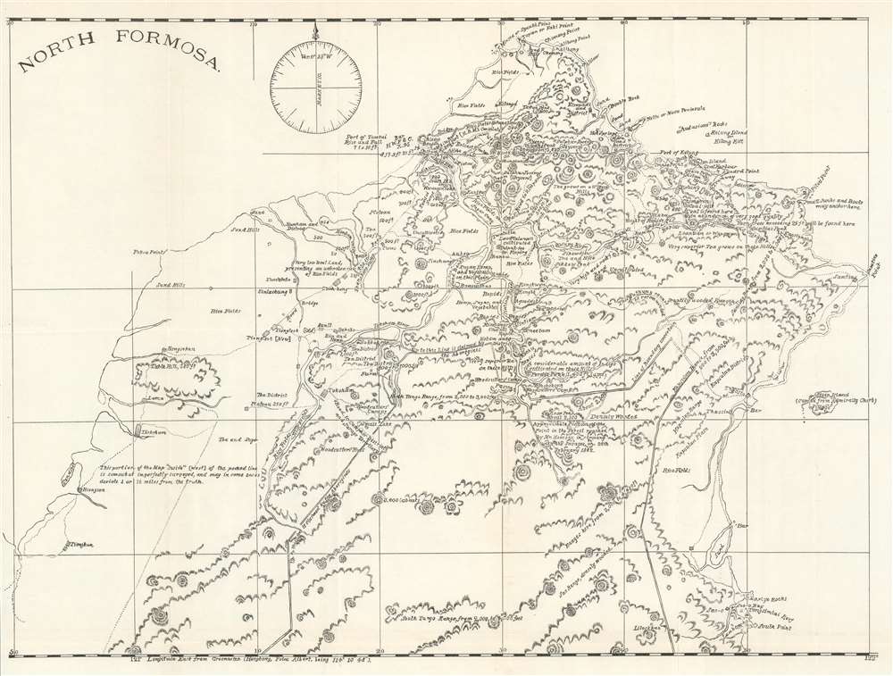
North Formosa.
1886 (undated) 17 x 22.5 in (43.18 x 57.15 cm) 1 : 211200
1886 (undated) 17 x 22.5 in (43.18 x 57.15 cm) 1 : 211200
Description
This is an 1886 Charles Denby map of northern Taiwan or Formosa. Impressive detail appears throughout, with towns and villages identified. Cultivated areas are labeled by the crops they produce: tea, indigo, hemp, and sugar cane. The British Consulate (labeled 'H.B.M.'s Consulate), customs house, Chinese beacon, and other landmarks also appear. The region's topography is illustrated and elevations for several peaks are given. A double line delineates between the area controlled by the Chinese and the area 'claimed by the Aborigines'. Denby's commentary adds another dimension to this work. Some of his labels include ' 'audacious' rocks', 'very superior Tea grows on these Hills' and 'this pathway cannot be recommended'.
Formosa in Denby's Own Words
In his Consular Report dated November 17, 1886, Denby focused on Formosa. The beginning of his report readsThe steady growth of the foreign trade of Formosa and the great military importance of the island, forming, as it does, to use the words of a recent memorial to the throne, 'a portal to the Southern China Sea and a bulwark for seven provinces', authorize me to call your attention to the present condition of the island and its importance in our trade with China.Denby's insights were prescient - if ignored by the American authorities. Within 10 yeas of this map's issue, another power, Imperial Japan, set its sights on Taiwan and invaded.
Although having nominally possession of Formosa since the latter part of the seventeenth century, the Chinese have only been able to establish their rule along the coast, the interior of the island, being still inhabited by independent tribes of aborigines who live chiefly by hunting, and who have ever shown unconquerable aversion to the Chinese.
In their fondness for head hunting they resemble the Dayaks of Borneo, and we learn from a recent memorial of the military administrator in Formosa that the murders committed by them number over a thousand yearly.
Publication History and Census
This map was published with Denby's report on Formosa entitled 'Importance of the Islands of Formosa in our trade with China' in Reports from the Consuls of the United States in January 1887. The separate map is not cataloged in OCLC.Cartographer
Charles Harvey Denby (June 16, 1830 - January 13, 1904) was an American diplomat and Army officer. Born in Mount Joy, Virginia, Denby attended the Tom Fox Academy as a youth. Denby's father, Nathaniel Denby, a ship-owner with interests in European trade, was named Naval Agent of the United States in Marseille, France, during Denby's childhood. The elder Denby elected to take his son with him to Marseille, where Charles Denby attended the College Royal and became fluent in French. Denby attended Georgetown College and the Virginia Military Institute. He graduated from VMI with high honors in 1850. After graduation, Denby taught school in Selma, Alabama, for three years. He moved to Evansville, Indiana, in 1853, which remained his home for the rest of his life. Denby studied law and worked for a newspaper in Evansville. During the 1856-57 session of the Indiana House of Representatives, Denby represented his county. After the outbreak of the American Civil War, Denby raised a company of volunteers and guarded the powder magazine in Evansville. He was commissioned as a lieutenant-colonel in the Union Army on September 12, 1861, and was made second-in-command of the 42nd Indiana Volunteer Infantry Regiment. Denby was promoted to Colonel on October 1, 1862 and put in command of a newly-formed regiment, the 80th Indiana Volunteer Infantry. However, he did not take command of the 80th Indiana until November 22, 1862, so he fought with the 42nd Indiana at the Battle of Perryville, Kentucky. He was wounded twice at Perryville and had his horse killed under him. Denby resigned his commission on January 12, 1863 and discharged from the army five days later on disability, citing 'a very severe leg cramp' for which doctors could find no cure. After his discharge, Denby returned to practicing law in Evansville and became active in the Democratic Party. After Grover Cleveland was elected President, Denby was put forward as a candidate for diplomatic service. He was made Minister to China on May 29, 1885 and held the post until July 11, 1898, when he either resigned or was removed from his post by President William McKinley. After returning to the United States in September 1898, Denby was appointed to a commission meant to look into the conduct of the Spanish American War. He then became a member the first commission to the Philippines (known as the Schurman Commission) along with Admiral George Dewey, General Elwell Stephen Otis, and two others. Denby died of a heart attack in Jamestown, New York, where he had gone to give a lecture. More by this mapmaker...
Condition
Very good. Exhibits wear along original fold lines. Verso repairs to fold separations. Blank on verso.