This copy is copyright protected.
Copyright © 2024 Geographicus Rare Antique Maps
1909 Garnier Pictorial Map of Paris, France w/Monuments
NouveauParis-garnier-1909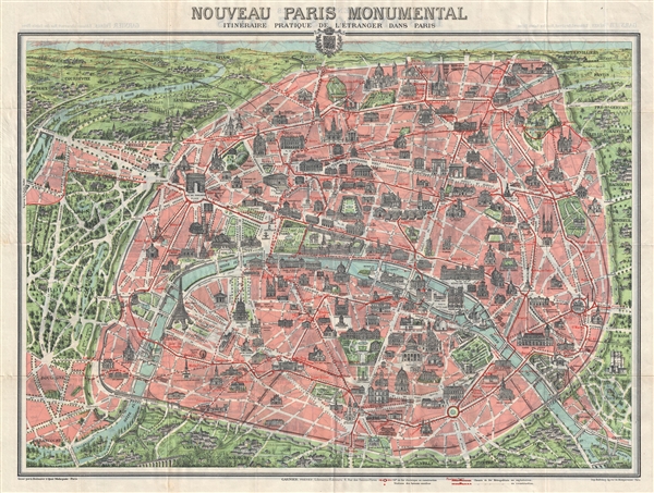

…the north, at the top, is capped by the Sacre-Coeur; the station at the Port d'Orleans marks a southern limit; to the west the maze of alleys in the Bois de Boulogne offers a fantasy of infinite promenades under leafy trees; to the east, at the Place de la Triomphe de la Republique, is found a sculpture celebrating secular France, that is protected by the moat-like circle of a subway line. A railway inside of a circular, crenelated wall of mediaeval aspect surrounds much of the city. Blocks of pink, denoting the inner space of the city, are cut by a broad swath of white lines indicating the width and length of Baron Haussmann's creation of boulevards. The Seine, colored in blue, bends its way through Paris, dividing the Right Bank (above) from a lesser mass of the Left Bank (below). The major monuments of the city are finely drawn and situated at their proper places. Yet their scale, of far greater proportion than that of the map itself, make clear that he city is an assemblage of enduring monuments…And indeed it is, the tableau of modern punctuated, as with the monuments illustrated here, by its long and fascinating history as a center of commerce, education, arts, and culture.
Garnier Frères (1833 - June, 1983) was a prominent publishing house and bookstore based in Paris, France. The publishing firm was founded in 1833 by the brothers Auguste (1812 - 1887) and Hippolyte Garnier (1815 or 1816 – 1859, photo at right). Their younger brother Pierre-Auguste (1807 – 1899) also joined the firm. Yet another brother, Baptiste-Louis Garnier (1822 - 1893) joined in 1844. The popular Paris bookshop, located in the arcades of the Palais-Royal in the gallery Peristyle Montpensier, followed shortly after in 1838. They opened another location in 1853 in the former government hotel, at the corner of rue de Lille and rue des Saints-Pères. The firm prospered through the publication of low cost editions French classics. Their corpus of work includes maps, guides, novels, historical works, and essays. In June of 1983 the firm filed for bankruptcy and their assents were taken over by Presses de la Cité, a subsidiary of InfoMédia, which was itself liquidated in 2000. More by this mapmaker...
Copyright © 2024 Geographicus Rare Antique Maps | Geographicus Rare Antique Maps
This copy is copyright protected.
Copyright © 2024 Geographicus Rare Antique Maps