This item has been sold, but you can get on the Waitlist to be notified if another example becomes available, or purchase a digital scan.
1882 Andriveau-Goujon Pocket Map of Paris, France
Paris-andriveau-1882$300.00

Title
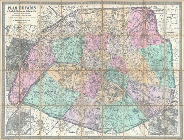
Plan de Paris a l'Echelle de 2 Millim, pour 25 Metres, Indiquant les Nouveaux percements et les changements de noms de Voies publiques avec plans supplementaires pour Les Bois de Boulogne et de Vincennes.
1882 (dated) 32.25 x 42 in (81.915 x 106.68 cm)
1882 (dated) 32.25 x 42 in (81.915 x 106.68 cm)
Description
A stunningly executed 1882 large format folding pocket map of Paris, France by E. Andriveau-Goujon. Focuses on the old walled center of Paris from Neuilly in the northwest to Pantin in the northeast, Issy in the southwest, and Ivry in the southeast. Inset maps detail the gardens of Bois de Boulogne and Bois de Vincennes. Offers extraordinary detail of the city on a scale of 1:12,500. Details individual buildings, streets, monuments, gardens and palaces. Shows exceptionally remarkable attention to detail in the public gardens where subtle expressions of landscape design are apparent. Predates the Eiffel tower. Color coded by arrondissement. Engraved by P. Mea of 70 Rue St. Victor, Paris for E. Andriveau-Goujon of 4 Rue du Bac, Paris, 1882.
Eugène Andriveau-Goujon (1832 - 1897) was a map publisher and cartographer active in 19th century Paris. The firm was created in 1825 when Eugène Andriveau married the daughter of map publisher Jean Goujon - thus creating Andriveau-Goujon. Maps by Andriveau-Goujon are often confusing to identify as they can be alternately singed J. Goujon, J. Andriveau, J. Andriveau-Goujon, E. Andriveau-Goujon, or simply Andriveau-Goujon. This refers to the multiple generations of the Andriveau-Goujon dynasty and the tendency to republish older material without updating the imprint. The earliest maps to have the Andriveau-Goujon imprint were released by Jean Andriveau-Goujon. He passed the business to his son Gilbert-Gabriel Andriveau-Goujon, who in 1858 passed to his son, Eugène Andriveau-Goujon, under whose management the firm was most prolific. Andriveau-Goujon published numerous fine pocket maps and atlases throughout the 19th century and often worked with other prominent French cartographers of the time such as Brue and Levasseur. The firm's stock was acquired by M. Barrère in 1892. Learn More...
Condition
Very good condition - no notable flaws. Detached from but accompanied by original linen binder. Disected into 37 sections and mounted on linen. Original linen backing in excellent condition.