This item has been sold, but you can get on the Waitlist to be notified if another example becomes available, or purchase a digital scan.
1863 Henriot Pocket Map of Paris, France
Paris-henriot-1863$300.00

Title
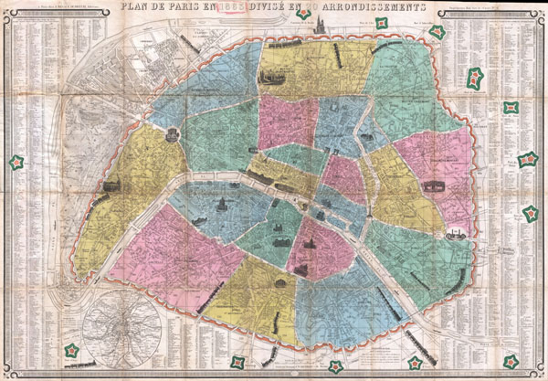
Plan de Paris en 1863 Divise en 20 Arrondissements.
1863 (dated) 23.5 x 34 in (59.69 x 86.36 cm)
1863 (dated) 23.5 x 34 in (59.69 x 86.36 cm)
Description
This is an extremely attractive 1863 tourist pocket map of Paris, France. Covers the old walled city of Paris and the immediate vicinity. Divided up into 20 arrondissments. Important buildings are shown in profile. Trains entering and leaving the city are also drawn in profile - a charming embellishment. The fourteen forts surrounding Paris are all noted. A street index, with most major and minor streets labeled, appears to the right and left of the map proper. Several small boats ply the Seine. A circular map of the Environs of Paris appears in the lower left quadrant. Keyboard style border. Prepared by J. N. Henriot for F. Dubreuil in 1863.
Cartographer
J. N. Henriot (fl. c. 1849 -1871) was a Paris based engraver and printer. Henriot worked in conjunction with A. Bes and F. Dubreuil, as well as other publishing firms of the day, to produce a number of widely distributed and popular maps of Paris and its environs. Like many French engravers of this period, little is known of his personal life and work. More by this mapmaker...
Condition
Very good. Original folds exhibit some wear and minor toning. Attached to original booklet.