This item has been sold, but you can get on the Waitlist to be notified if another example becomes available, or purchase a digital scan.
1701 Moll Map of Uruguay, Paraguay, Southern Brazil, Argentina (El Dorado)
RioDeLaPlata-moll-1701$100.00

Title
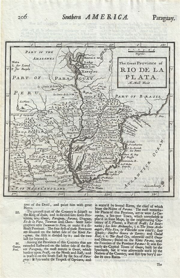
The Great Province of Rio de la Plata.
1701 (undated) 8.5 x 8 in (21.59 x 20.32 cm) 1 : 17500000
1701 (undated) 8.5 x 8 in (21.59 x 20.32 cm) 1 : 17500000
Description
This is a beautiful 1701 map of Uruguay, Paraguay, northern Argentina and southern Brazil by Herman Moll. It covers from the Rio de la Plata north well into Brazil and the Amazon. Includes the modern day nations of Uruguay, Paraguay, and parts of adjacent Brazil and Argentina.
Perhaps the most interesting element of this map is the representation of the apocryphal Lake of Xarayes at the northern terminus of the Paraguay River. 'Xarayes' is a corruption of 'Xaraies' meaning 'Masters of the River.' The Xaraies were an indigenous people occupying what are today parts of Brazil's Matte Grosso and the Pantanal. When Spanish and Portuguese explorers first navigated up the Paraguay River, as always in search of El Dorado, they encountered the vast Pantanal flood plain at the height of its annual inundation. Understandably misinterpreting the flood plain as a gigantic inland sea, they named it after the local inhabitants, the Xaraies. The Laguna de los Xarayes almost immediately began to appear on early maps of the region and, at the same time, almost immediately took on a legendary aspect as the gateway to El Dorado. Later missionaries and chroniclers, particularly Diaz de Guzman, imagined an island in this lake and curiously identified it as an 'Island of Paradise,'
Perhaps the most interesting element of this map is the representation of the apocryphal Lake of Xarayes at the northern terminus of the Paraguay River. 'Xarayes' is a corruption of 'Xaraies' meaning 'Masters of the River.' The Xaraies were an indigenous people occupying what are today parts of Brazil's Matte Grosso and the Pantanal. When Spanish and Portuguese explorers first navigated up the Paraguay River, as always in search of El Dorado, they encountered the vast Pantanal flood plain at the height of its annual inundation. Understandably misinterpreting the flood plain as a gigantic inland sea, they named it after the local inhabitants, the Xaraies. The Laguna de los Xarayes almost immediately began to appear on early maps of the region and, at the same time, almost immediately took on a legendary aspect as the gateway to El Dorado. Later missionaries and chroniclers, particularly Diaz de Guzman, imagined an island in this lake and curiously identified it as an 'Island of Paradise,'
...an island [of the Paraguay River] more than ten leagues [56 km] long, two or three [11-16 km] wide. A very mild land rich in a thousand types of wild fruit, among them grapes, pears and olives: the Indians created plantations throughout, and throughout the year sow and reap with no difference in winter or summer, ... the Indians of that island are of good will and are friends to the Spaniards; Oregon they call them, and they have their ears pierced with wheels of wood ... which occupy the entire hole. They live in round houses, not as a village, but each apart though keep up with each other in much peace and friendship. They called of old this island Land of Paradise for its abundance and wonderful qualities.This map was issued in Herman Moll's 1701 System of Geography.
Cartographer
Herman Moll (1654 - 1732) was an important 18th century map publisher and engraver based in London and Holland. Moll's origins are disputed with some suggesting he was born in the Netherlands and others Germany - the Moll name was common in both countries during this period. Most likely Moll was a German from Bremen, as his will, friends, and contemporaries suggest. What is known for certain is that he moved to London in 1678, possibly fleeing the Scanian War, where he worked as an engraver for Moses Pitt and other London map publishers. Around the turn of the century, Moll set up his own shop where he produced a large corpus of work known for its high quality and decorative flair. As a new émigré to England, Moll made himself more English than the English, and through his cartography proved a fierce advocate for his adopted nation. Most of Moll's early maps were issued as loose sheets that would be bound to order, however, he did publish several important atlases late in his career. Moll is said to have made the bold claim that without a doubt "California is an Island" and that he "had in [his] office mariners who have sailed round it." While California may not be an island (yet), it is true that moll had talent for attracting interesting friends and acquaintances. He frequented London's first stock exchange, Jonathan's Coffeehouse at Number 20 Exchange Alley, Cornhill. At the time Jonathan's was known as "a place of very considerable concourse for Merchants, sea faring Men and other traders" (Erleigh, The Viscount, The South Sea Bubble, Manchester: Peter Davies, Ltd., 1933, 21). Eventually this activity attracted the interest of stock brokers, who inspired by sailor's tales, sponsored the ill-fated South Sea Company, the world's first stock bubble. Moll's close circle, mostly from the Coffee House, included scientist Robert Hooke, the writers Daniel Defoe (Robinson Crusoe) and Jonathan Swift (Gulliver's Travels), the pirates William Dampier, William Hacke and Woodes Rogers, and the archeologist William Stukeley. Herman Moll's work was highly regarded for its decorative beauty and was pirated, most notably by the Irish publisher George Grierson, both in his lifetime and after his 1732 death at St. Clement Danes, London. More by this mapmaker...
Source
Moll, H., A System of Geography: Or, A New and Accurate Description of the Earth In all its Empires, Kingdoms and States (London), 1701.
Herman Moll's A System of Geography was first published in 1701. A System of Geography was essentially a larger version of Timothy Childe and Abel Swall's 1695 Thesaurus Geographicus, for which Moll engraved several maps. The enormous success of the Thesaurus Geographicus most likely provided the inspiration for Moll to publish a more complete atlas of his own, which finally resolved into the 1701 issue of A System of Geography. The additional maps included in A System of Geography were stamped 'New' to distinguish them from those rolled over from the Thesaurus. A System of Geography was issued in two parts containing numerous maps as well as extensive descriptive text. It was printed in London by both Timothy Childe and J. Churchill.
Condition
Very good. Original platemark visible. Minor spotting. Text on verso.
References
OCLC : 225273701.