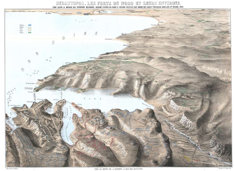
This is a c. 1855 Auguste Logerot bird's-eye view map of the siege of Sevastopol (Sebastopol) during the Crimean War. Sevastopol, the largest city on the Crimean Peninsula, occupies the foreground and is illustrated in detail. Numerous forts, redoubts, and other fortifications are identified, along with artillery batteries and even a few lighthouses. Russian, British, French, and Ottoman troop positions are colored. The Battle of Inkermann and the fighting at Koughil are directly referenced on the view.
The Siege of Sevastopol
The siege of Sebastopol, the final battle of the Crimean War, took place from October 1854 until September 1855. Sevastopol is remembered as one of the classic sieges of all time. The city housed Russia's Black Sea Fleet, which posed a threat to the entire Mediterranean Sea. The siege was immortalized in Leo Tolstoy's Sebastopol Sketches. Tolstoy, the now world-famous author of works including War and Peace and Anna Karenina, was a 26-year-old artillery officer in the Russian army and survived the 11-month siege. The Crimean War
The Crimean War, with an alliance of the Ottoman Empire, Britain, France, and Sardinia on one side of the conflict and the Russian Empire on the other, lasted from October 1853 until February 1856. The root cause of the war has never been fully understood, but the stated impetus for hostilities was the rights of Christians in the Holy Land, with the Catholics being supported by the French and the Greek Orthodox Church gaining the support of the Russians. Other factors also included the gradual decline of the Ottoman Empire and British and French concerns about Russian gains in the region at the cost of the Ottomans.
Hostilities erupted in July 1853 when Russia invaded two Ottoman suzerainties known collectively as the Danubian Principalities. The Ottomans immediately responded and fought a defensive campaign that eventually halted the Russian advance at Silistra, which the Russians besieged. Alarmed by the possibility of an Ottoman collapse, the British and French jumped to their aid, sending troops and supplies to Gallipoli. These reinforcements did not arrive at Silistra until after the Russians had withdrawn.
Now, public opinion at home, where discontent at the seemingly wasted effort and expense of sending armies to the Balkans, exerted an influence on the alliance. This outcry led to the planning and execution of an invasion of the Crimean Peninsula in September and a siege of the Russian naval port of Sevastopol, their primary naval base in the Black Sea, which lasted for eleven months. Russia finally sued for peace in March 1856. In the Treaty of Paris that ended the war, Russia lost its Black Sea ports. Wallachia and Moldavia gained a modicum of independence, and Christians in the Holy Land were given a degree of equality.Publication History and Census
This view was published c. 1855 by Auguste Logerot. It was drawn by H.J. van den Hout and engraved and printed by Rose Joseph Lemercier. An empty OCLC reference appears for this work, suggesting that an institution that was once part of OCLC cataloged it at one point.
CartographerS
Auguste Logerot (fl. c. 1839 - c. 1880) was a French map and general interest publisher active throughout the mid to late 19th century. A. Logerot worked with other French publishers, cartographers and engravers of the period including Fremin, Dufour, Dyonnet, and Vuillemin. He published a large corpus of map and geographical atlases, though few of his map represented unique or exceptionally interesting work. This exception are his wonderful jigsaw puzzle maps - a style popular in 19th century France. Jigsaw puzzle maps are a kind of educational map printed on board and carved up in puzzle format. Logerot's imprint is frequently misprinted as Lagerot or Logeret. Logerot shared offices with several other publishers, printers and engravers at Quai des Augustins 55, Paris. Little else is known of Logerot's life and work. More by this mapmaker...
Rose-Joseph Lemercier (June 29, 1803 - 1887) was a French photographer, lithographer, and printer. One of the most important Parisian lithographers of the 19th century, Lemercier was born in Paris into a family of seventeen children. His father was a basket maker, and he even began working as a basket maker at the age of fifteen, but Lemercier was drawn to lithography and printing and soon entered into an apprenticeship with Langlumé, where he worked from 1822 until 1825. After working for a handful of other printers, Lemercier started his own firm in 1828 at 2, rue Pierre Sarrazin with only one printing press. He subsequently moved a few more times before arriving at 57, rue de Seine, where he founded the printing firm Lemercier and Company. Lemercier created the firm Lemercier, Bénard and Company in 1837 with Jean François Bénard. Lemercier bought out Bénard's share in the firm in 1843 and, since his two sons died at a young age, he decided to bring his nephew Alfred into the business beginning in 1862, who would progressively take on more and more responsibility in running the firm. Between 1850 and 1870, Lemercier's firm was the largest lithographic company in Paris. The firm began to decline in prestige in the early 1870s, and, after Lemercier's death in 1887, its descent only quickened. It is unclear when the firm closed, but Alfred directed the firm until his death in 1901. Learn More...
Good. Exhibits wear and toning along original fold lines. Verso repairs to fold separations. Closed tears extending one inch and one half-inch respectively into printed area from bottom border professionally repaired on verso. Blank on verso.
OCLC 557442856.