
Lemercier, Rose-Joseph
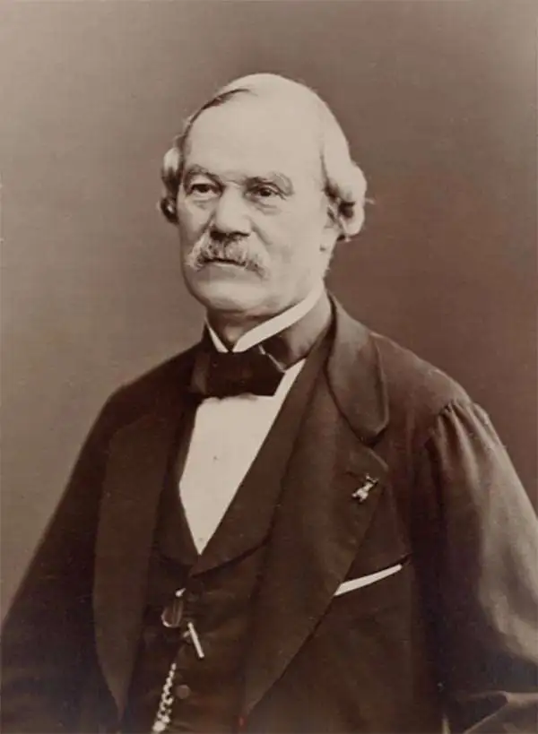
Rose-Joseph Lemercier (June 29, 1803 - 1887) was a French photographer, lithographer, and printer. One of the most important Parisian lithographers of the 19th century, Lemercier was born in Paris into a family of seventeen children. His father was a basket maker, and he even began working as a basket maker at the age of fifteen, but Lemercier was drawn to lithography and printing and soon entered into an apprenticeship with Langlumé, where he worked from 1822 until 1825. After working for a handful of other printers, Lemercier started his own firm in 1828 at 2, rue Pierre Sarrazin with only one printing press. He subsequently moved a few more times before arriving at 57, rue de Seine, where he founded the printing firm Lemercier and Company. He created the firm Lemercier, Bénard and Company in 1837 with Jean François Bénard. Lemercier bought out Bénard's share in the firm in 1843 and, since his two sons died at a young age, he decided to bring his nephew Alfred into the business beginning in 1862, who would progressively take on more and more responsibility in running the firm. Between 1850 and 1870, Lemercier's firm was the largest lithographic company in Paris. The firm began to decline in prestige in the early 1870s, and, after Lemercier's death in 1887, its descent only quickened. It is unclear when the firm closed, but Alfred directed the firm until his death in 1901.
Striking large anatomical studies.
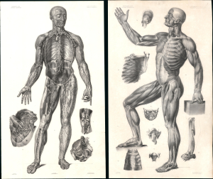
Angéiologie planche 14, vaisseaux lymphatiques. / Planche 7. Myologie aponévrologie. Plan lateral.
$3,000.00
Acquire
- Digital Map Information
- Suitable for large format printing
- File Size: 85.19 MB
- File Type: ZIP / TIFF
- ICC color profile embedded
- Delivered instantly via download link
This is a striking c. 1839 pair of landmark lithographic anatomic studies by anatomist Jean-Marc Bourgery and artist Nicolas-Henri Jacob. The left study (14) represents the lymphatic system, while the right (7) is a profile illustration of the muscular system. Both were issued as part of a landmark collection of 20 large-scale plates issued in a loose-leaf anatomical atlas entitled Anatomie élémentaire en 20 planches. (more details)
Oh how things have changed.
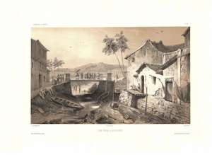
Vue Prise a Sincapour.
$1,000.00
Acquire
- Digital Map Information
- Suitable for large format printing
- Full resolution TIFF file
- ICC color profile embedded
- Delivered instantly via download link
One of the earliest obtainable views of Singapore, this c. 1840 image was drawn by Barthélemy Lauvergne. The 2-color chromolithograph view likely looks east along Singapore River with the old bridge on South Bridge Road at center. Beyond, Battery Point with a hint of fortifications is evident. The low water level and dock extending into empty space underscores that this view was done during the dry season. The Chinese Campong is on the right - note the Chinese characters above the door.
Lauvergne was one of several artists accompanying the 1836 - 1837 Auguste-Nicolas Vaillant (1793 - 1858) circumnavigation. The scientific expedition arrived in Singapore on February 17, 1837 and stayed through February 23rd. It is safe to assume that Lauvergne sketched this view during the expedition's brief stay. (more details)
Lauvergne was one of several artists accompanying the 1836 - 1837 Auguste-Nicolas Vaillant (1793 - 1858) circumnavigation. The scientific expedition arrived in Singapore on February 17, 1837 and stayed through February 23rd. It is safe to assume that Lauvergne sketched this view during the expedition's brief stay. (more details)
llustrates Notre Dame, the Louvre, the Pantheon, and the bridges of the Seine among other Paris landmarks.
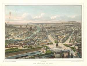
Vue Générale de Paris. Prise de la colonne de Juillet. (Sud-Est.)
$750.00
Acquire
- Digital Map Information
- Suitable for large format printing
- DPI: 600
- File Size: 18.77 MB
- File Type: ZIP / TIFF
- ICC color profile embedded
- Delivered instantly via download link
This is a c. 1845 Nicolas Chapuy view of Paris. The view looks west over the City of Light with the Place de la Bastille and the Colonne de Juillet in the foreground. The Canal Saint Martin crosses beneath the Place de la Bastille in the foreground, with the Rue Saint-Antoine and the Boulevard Beaumarchais leading away from the column. The Place des Vosges, the square of houses surrounding a park, can be seen just behind the Colonne de Juillet and was the first planned square in Paris. Further along the Rue Saint-Antoine, the Église Saint-Gervais is illustrated, just across the Seine from Notre Dame. The Louvre and the Tuileries Gardens are also discernable, as are Les Invalides and the Panthéon (along the left border). Numerous other churches are included throughout Paris. The bridges of the Seine are beautifully illustrated. In the distance, practically on the horizon, the recently completed Arc de Triomphe is visible, but only just. (more details)
One of the earliest illustrations of a lūʻau.
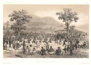
Scene De Danse Aux Iles Sandwich / [Dance Scene in the Sandwich Islands].
$500.00
Acquire
- Digital Map Information
- Suitable for large format printing
- Full resolution TIFF file
- ICC color profile embedded
- Delivered instantly via download link
This c. 1845 chromolithograph Lauvergne view is one of the earliest representations of a Hawaiian lūʻau (luau). Hawaiians dance and feast while a crowd including crewmembers of the French ship La Bonite observe. The view was sketched by Barthélémy Lauvergne, one of the resident artists on the Bonite Expedition (1836 -1837), a French scientific and diplomatic circumnavigation. (more details)
Dramatization of ships on the Hawaiian coast during the 'Bonite Expedition.'
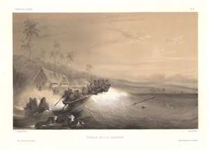
Echouage aux Iles Sandwich / [Stranding in the Sandwich Islands].
$450.00
Acquire
- Digital Map Information
- Suitable for large format printing
- Full resolution TIFF file
- ICC color profile embedded
- Delivered instantly via download link
This is a c. 1845 chromolithograph Lauvergne view of ships off the Hawaii (Sandwich Islands) coast. The view was sketched by Barthélémy Lauvergne, one of the resident artists on the Bonite Expedition (1836 -1837), a French scientific and diplomatic circumnavigation. (more details)
Victorian pastoral aesthetics in the tropics.
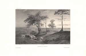
Environs de Sincapour.
$700.00
Acquire
- Digital Map Information
- Suitable for large format printing
- DPI: 600
- File Size: 33.39 MB
- File Type: ZIP / TIFF
- ICC color profile embedded
- Delivered instantly via download link
This is a rare c. 1845 chromolithograph of the countryside of Singapore in the early days of British rule by Barthélémy Lauvergne, one of the resident artists on the Bonite Expedition (1836 -1837), a French scientific and diplomatic circumnavigation. (more details)
A pleasant pastoral view of early Singapore.
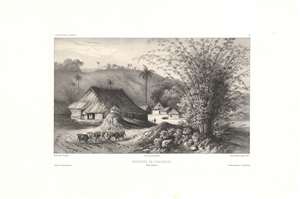
Environs de Sincapour, Détroit de Malacca.
$700.00
Acquire
- Digital Map Information
- Suitable for large format printing
- DPI: 600
- File Size: 26.45 MB
- File Type: ZIP / TIFF
- ICC color profile embedded
- Delivered instantly via download link
This is a rare c. 1845 chromolithograph of a rural scene in the early days of British Singapore by Barthélémy Lauvergne, one of the resident artists on the Bonite Expedition (1836 - 1837), a French scientific and diplomatic circumnavigation. (more details)
An early depiction of Nuʻuanu Pali, the gateway to Honolulu.
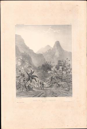
Vallée du Pari près Honoloulou, Iles Sandwich.
$500.00
Acquire
- Digital Map Information
- Suitable for large format printing
- Full resolution TIFF file
- ICC color profile embedded
- Delivered instantly via download link
This is a rare 1845 lithograph view of Nuʻuanu Pali, a cliff face and mountain pass in at the head of the Nuʻuanu Valley near Honolulu, Hawaii. This historically and culturally important site is depicted here by Théodore Auguste Fisquet, one of the designated ship artists for the Bonite expedition, an 1836 - 1837 French voyage around the world. (more details)
Key sites in the Atlantic Slave Trae.
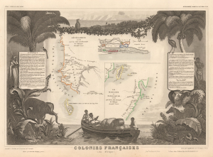
Colonies Françaises (en Afrique).
$175.00
Acquire
- Digital Map Information
- Suitable for large format printing
- File Size: 16.35 MB
- File Type: ZIP / TIFF
- ICC color profile embedded
- Delivered instantly via download link
This is a 1847 Victor Levasseur map of the French colonies of Madagascar, Senegal, and the Gambia. The map captures key sites associated with the Atlantic Slave Trade, including the infamous Gorée. (more details)
One of the classic sieges in all of history and survived by Leo Tolstoy.
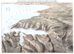
Sebastopol, Les Forts du Nord et Leurs Environs. Pour suivre la marche des opérations militaires, dessiné d'après les plans et dessins par ordre des gouvernements français, anglais et russe, etc.
$850.00
Acquire
- Digital Map Information
- Suitable for large format printing
- File Size: 45.31 MB
- File Type: ZIP / TIFF
- ICC color profile embedded
- Delivered instantly via download link
This is a c. 1855 Auguste Logerot bird's-eye view map of the siege of Sevastopol (Sebastopol) during the Crimean War. Sevastopol, the largest city on the Crimean Peninsula, occupies the foreground and is illustrated in detail. Numerous forts, redoubts, and other fortifications are identified, along with artillery batteries and even a few lighthouses. Russian, British, French, and Ottoman troop positions are colored. The Battle of Inkermann and the fighting at Koughil are directly referenced on the view. (more details)
Decoding the Dead Sea.
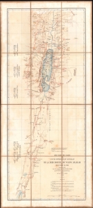
Réduction des cartes du cours inférieur du Jourdain, de la mer Morte, du wady Arabah et du wady El Jeib.
$1,200.00
Acquire
- Digital Map Information
- Suitable for large format printing
- File Size: 13.15 MB
- File Type: ZIP / TIFF
- ICC color profile embedded
- Delivered instantly via download link
A scarce 1866 separate-issue folding map of the Dead Sea and the Jordan Rift Valley by Louis Vignes. It was the product of the Duc de Luynes's 1864 expedition to the Dead Sea, noted for its scientific discoveries, as well as the early photographs of the region taken by Vignes. (more details)
Earliest Official Map of the Suez Canal.
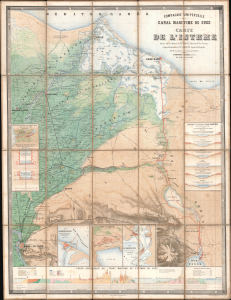
Compagnie Universelle du Canal Maritime de Suez Carte de l'Isthme.
$5,000.00
Acquire
- Digital Map Information
- Suitable for large format printing
- Full resolution TIFF file
- ICC color profile embedded
- Delivered instantly via download link
This is a 1866 large-format chromolithographic folding map issued by the Compagnie universelle du canal maritime de Suez, under the direction of its chief engineer, François-Philippe Voisin. Published in 1866, three years before the canal's completion, this rare first edition of the official canal map is among the most visually compelling and technically detailed maps ever made of the project. During World War I (1914 - 1918), the Imperial German Army deemed it so accurate and useful that it issued a faithful pirated edition for commanders planning an assault on the canal. (more details)
The end of the Paris Commune.
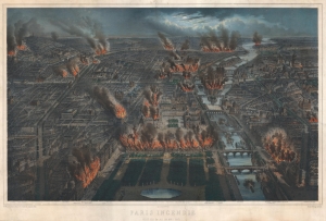
Paris Incendié Nuit du 24 au 25 Mai 1871.
$1,800.00
Acquire
- Digital Map Information
- Suitable for large format printing
- File Size: 65.9 MB
- File Type: ZIP / TIFF
- ICC color profile embedded
- Delivered instantly via download link
This is a c. 1871 Michel Charles Fichot chromolithograph view of Paris burning during the last week of the Paris Commune. Buildings, including the Palais des Tuileries, appear engulfed in flames embellished by striking hand color. (more details)
Between Paraguay and Argentina.
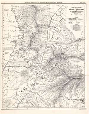
Carte Historique de la Province des Missions et Établissements des Jésuites sur le Parana et l'Uruguay de 1575 a 1766.
$1,200.00
Acquire
- Digital Map Information
- Suitable for large format printing
- File Size: 62.69 MB
- File Type: ZIP / TIFF
- ICC color profile embedded
- Delivered instantly via download link
This is an 1865-dated (1873) map of Paraguay and the neighboring Missions Province, an often-contested land between that country, Uruguay, and the Argentine Confederation. It was the work of French émigré physician and surveyor Martin de Moussy (Victor) who explored the region on behalf of the Argentine Confederation. It is a superbly detailed work, marking current settlements and former Jesuit ones, Indigenous regions, and the locations of battles fought in the 1851-52 Platine War, during which Martin had served in the Argentine National Guard. (more details)
A moment of change.
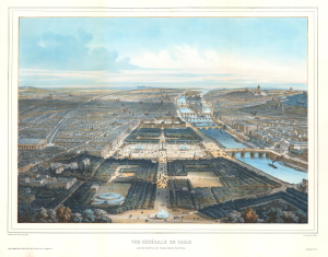
Vue Générale de Paris prise du Rond-Point des Champs-Elysées, Nord-Ouest.
$950.00
Acquire
- Digital Map Information
- Suitable for large format printing
- Full resolution TIFF file
- ICC color profile embedded
- Delivered instantly via download link
This is an exceptional c. 1896 Michel Charles Fichot chromolithograph bird's-eye view map of Paris, France. The view looks southeast down the Champs-Élysées towards the Place de la Concorde, the Jardin des Tuileries, and the Louvre. The Seine, with its iconic bridges, curves through the heart of the city. Pedestrians, carriages, and a battalion of soldiers ply the streets, emphasizing the bustling French capital. (more details)