1828 Arrowsmith Map of Spain and Portugal
SpainPortugal-arrowsmith-1828$100.00

Title
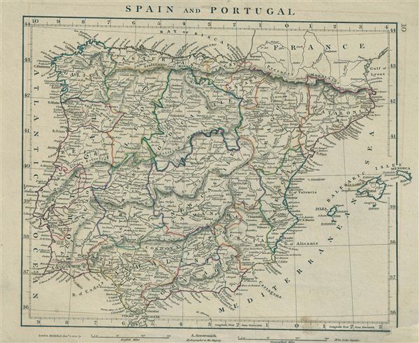
Spain and Portugal.
1828 (dated) 11 x 13 in (27.94 x 33.02 cm)
1828 (dated) 11 x 13 in (27.94 x 33.02 cm)
Description
This is a rare example of Aaron Arrowsmith's 1828 map of Spain and Portugal. The map covers the Iberian Peninsula from the Bay of Biscay in the north to the Strait of Gibraltar in the south and from Algarve in Portugal to Catalonia in the East. Includes the Balearic Islands of Minorca, Majorca, and Ibiza. The regional political boundaries are colored and relief shown by hachures. During this period Portugal on the cusp of the War of the Two Brothers. In 1826, Peter IV of Portugal abdicated his thrown in favor of his seven year old daughter Maria da Gloria, on the condition that she marry her uncle (Peter's brother) Miguel. Miguel deposed Maria and proclaimed himself King, which led to the Liberal Wars, and eventually resulted in Miguel being forced to abdicate and go into exile, and Maria II being proclaimed Queen. During this same period, in Spain, the death of Ferdinand VII also saw his daughter, Isabella II, an infant at the time, proclaimed Queen. This would also lead to the First Carlist War in Spain from 1833-1839. This map was published by A. Arrowsmith, hydrographer to His Majesty, in 1828.
Cartographer
Aaron Arrowsmith (1750-1823), John Arrowsmith (1790-1873), and Samuel Arrowsmith. The Arrowsmith family were noted map engravers, publishers, geographers, and cartographers active in the late 18th and early 19th century. The Arrowsmith firm was founded by Aaron Arrowsmith, who was trained in surveying and engraving under John Cary and William Faden. Arrowsmith founded the Arrowsmith firm as a side business while employed by Cary. The firm specialized in large format individual issue maps containing the most up to date and sophisticated information available. Arrowsmith's work drew the attention of the Prince of Wales who, in 1810, named him Hydrographer to the Prince of Wales, and subsequently, in 1820, Hydrographer to the King. Aaron Arrowsmith was succeeded by two sons, Aaron and Samuel, who followed him in the map publication business. The Arrowsmith firm eventually fell to John Arrowsmith (1790-1873), nephew of the elder Aaron. John was a founding member of the Royal Geographical Society. The firm is best known for their phenomenal large format mappings of North America. Mount Arrowsmith, situated east of Port Alberni on Vancouver Island, British Columbia, is named for Aaron Arrowsmith and his nephew John Arrowsmith. More by this mapmaker...
Condition
Very good. Original platemark visible. Blank on verso. Verso repair to damage on bottom right corner of map. Minor stain near bottom right margin.
References
Rumsey 0028.011. (1812 edition).