
This item below is out of stock, but another example (left) is available. To view the available item, click "Details."
Details
1814 Thomson Map of Mexico and Texas
$650.00
1814 Thomson Map of Mexico and Texas
SpanishNorthAmerica-thomson-1814$325.00

Title
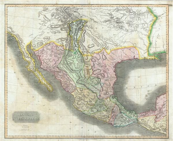
Spanish North America.
1814 (dated) 20 x 24.5 in (50.8 x 62.23 cm) 1 : 6200000
1814 (dated) 20 x 24.5 in (50.8 x 62.23 cm) 1 : 6200000
Description
This beautiful 1814 map, along with Pinkerton's similar map, is most likely the most important large format English atlas map of the American Southwest to be produced in the 19th century. The map depicts Mexico from the Yucatan north to what would soon become the Republic of Texas, the Louisiana Territory, and what would eventually be the U.S. States of New Mexico, Arizona, Texas, California, Nevada, Utah, Louisiana, Oklahoma and Colorado. Based largely on the maps of Alexander von Humboldt and Zebulon Pike, the general treatment of the Rocky Mountains is drawn directly from Humboldt's important map of 1811, issued just 3 years prior. The 1806 – 1807 explorations of Zebulon Pike in modern-day Colorado are also in evidence, as is Pike's Peak, here noted as the 'Highest Peak.' The name Texas appears on this map only as the name of a settlement on the Colorado River, which is here mapped twice. The Great Salt Lake is mapped according to the limited knowledge preserved from the Escalante-Onate expedition of 1776. Here both the Great Salt Lake and Utah Lake are mapped, both with indistinct borders. The Louisiana region is especially well notated with numerous annotations regarding the Indian tribes inhabiting the region and a number of advances over Humboldt – such as the correct mapping of the Arkansas River.
Dated: 'Drawn and Engraved for Thomsons New General Atlas 1814,' this is the first edition of Thomson's map from the 1814 edition of the Atlas. Subsequent editions were published in 1817 and 1826. This map is an essential addition to any serious Texas, Transmississippi, or Southwest collection.
Dated: 'Drawn and Engraved for Thomsons New General Atlas 1814,' this is the first edition of Thomson's map from the 1814 edition of the Atlas. Subsequent editions were published in 1817 and 1826. This map is an essential addition to any serious Texas, Transmississippi, or Southwest collection.
Cartographer
John Thomson (1777 - c. 1841) was a Scottish cartographer, publisher, and bookbinder active in Edinburgh during the early part of the 19th century. Thomson apprenticed under Edinburgh bookbinder Robert Alison. After his apprenticeship, he briefly went into business with Abraham Thomson. Later, the two parted ways, John Thomson segueing into maps and Abraham Thomson taking over the bookbinding portion of the business. Thomson is generally one of the leading publishers in the Edinburgh school of cartography, which flourished from roughly 1800 to 1830. Thomson and his contemporaries (Pinkerton and Cary) redefined European cartography by abandoning typical 18th-century decorative elements such as elaborate title cartouches and fantastic beasts in favor of detail and accuracy. Thomson's principle works include Thomson's New General Atlas, published from 1814 to 1821, the New Classical and Historical Atlas of 1829, and his 1830 Atlas of Scotland. The Atlas of Scotland, a work of groundbreaking detail and dedication, would eventually bankrupt the Thomson firm in 1830, at which time their plates were sequestered by the court. The firm partially recovered in the subsequent year, allowing Thomson to reclaim his printing plates in 1831, but filed again for bankruptcy in 1835, at which time most of his printing plates were sold to A. K. Johnston and Company. There is some suggestion that he continued to work as a bookbinder until 1841. Today, Thomson maps are becoming increasingly rare as they are highly admired for their impressive size, vivid hand coloration, and superb detail. More by this mapmaker...
Source
Thomson, J. A New General Atlas, (Edinburgh) 1814.
Thomson's New General Atlas was first published in 1817 and continued to be published until about 1821. This is the first of Thomson's major cartographic works and the atlas for which is most celebrated. The New General Atlas follows in the Edinburgh School, which eschews excessive decoration in favor of a more minimalistic fact-based cartographic vision, as established by John Pinkerton, Laurie and Whittle, John Cary, and others in the previous decades. The maps are notable for their massive scale, heavy stock, elegant color work, and easy-to-read typefaces. Although the atlas stopped being published after 1821, Thomson continued to offer 'supplementary' maps that could be tipped into the atlas as late as 1830, when he declared bankruptcy. The maps in the Thomson Atlas were engraved by Thomas Clerk, William Dassauville, Nathaniel Rogers Hewitt, James Kirkwood, Robert Kirkwood, John Menzies, George Menzies, Edward Mitchell, John Moffatt, Samuel John Neele, Robert Scott, and James Wyld.
Condition
Very good condition. Some offsetting. Original centerfold. Blank on verso.
References
Rumsey 1007.064 (1817 edition). Wheat, Carl Irving, Mapping the Transmississippi West, 1540-1861 (5 vols), #320. Taliaferro, H.G., Cartographic Sources in the Rosenberg Library, 206. Bancroft Library: G4410 1814 S6. Catalogue of Maps of Hispanic America, v. 1 p. 86 (1828 edition). Phillips (Atlases) 731.