This item has been sold, but you can get on the Waitlist to be notified if another example becomes available, or purchase a digital scan.
1710 De La Feuille Map of Transylvania & Moldova
Transylvania-leafeuille-1710$115.00

Title
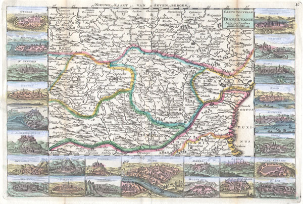
Carte Nouvelle de Transilvanie Avec ses Consins
1710 7 x 10.5 in (17.78 x 26.67 cm)
1710 7 x 10.5 in (17.78 x 26.67 cm)
Description
A very scarce, c. 1710, map of Transylvania and Moldova by Daniel de la Feuille. Depicts the region of eastern Europe just west of the Black Sea, south of the Ukraine, and north of Bulgaria. Features inset views of 25 important regional trading centers: Gyulla, Solnoce, St. Servaes, Hatwan, Vicigrad, St. Martins Bergh, Novigrad, Waitzon, Planka Trigell, Palotta, Nitrie, Villeck, Bude, Darda, Buzin, Esseck, Belgrade, St. Iob, Cinq-Eglises, Signet, Romore,Raab, Papa, Vesprin and Dotis. Also indicates the course of the Danube River from the black sea as far west as Razena. An alternate titlein Dutch is printed above the top border of the map, 'Nieuwe Kaart van Seven Bergen.' Long after this map was published, in 1888, Emily Gerard published The Land Beyond the Forest, an account of Transylvanian folklore that included legends about Vampires. Nine years later Bram Stoker popularized the notion and brought fame (infamy?) to Transylvania in his classic novel of gothic horror, Dracula. This map was originally prepared for inclusion as chart no. 10 in the 1702 edition of De la Feuille's Atlas Portatif. This map is from the Dutch 1710 edition.
Cartographer
Daniel de La Feuille (1640 - 1709) was born of Huguenot stock in Sedan (L'Ardennes), France. As a young man he apprenticed as a watchmaker. In 1663 La Feuille married Charlette Marlet, the daughter of a local carpenter. Twenty years later, in 1683, facing religious prosecution of Huguenots in France, the family fled to Amsterdam. By 1686 Daniel had become a burgher (citizen) of the city and established himself as an engraver, publisher, and art dealer. Not long after, in 1691, he was admitted into the Booksellers Guild. Though we are primarily concerned with his cartographic work here, his masterpiece is considered to be Devises et emblems, a collection of symbols and designs mostly likely intended as templates for silversmiths, engravers, and watchmakers. His cartographic work includes numerous individual maps and atlases, many of which continued to be published and republished well after his death in 1709. He was succeeded by his sons Jacob de la Feuille (1668 - 1719) and Paul de La Feuille (1688 - 1727). More by this mapmaker...
Condition
Very Good condition. Minor discoloration along the original folds – see photo. Minor fold separation limited to wide marginal region. Original plate-mark visible. Else clean and beautiful.