
Feuille, Daniel de La

Daniel de La Feuille (1640 - 1709) was born of Huguenot stock in Sedan (L'Ardennes), France. As a young man he apprenticed as a watchmaker. In 1663 La Feuille married Charlette Marlet, the daughter of a local carpenter. Twenty years later, in 1683, facing religious prosecution of Huguenots in France, the family fled to Amsterdam. By 1686 Daniel had become a burgher (citizen) of the city and established himself as an engraver, publisher, and art dealer. Not long after, in 1691, he was admitted into the Booksellers Guild. Though we are primarily concerned with his cartographic work here, his masterpiece is considered to be Devises et emblems, a collection of symbols and designs mostly likely intended as templates for silversmiths, engravers, and watchmakers. His cartographic work includes numerous individual maps and atlases, many of which continued to be published and republished well after his death in 1709. He was succeeded by his sons Jacob de la Feuille (1668 - 1719) and Paul de La Feuille (1688 - 1727).
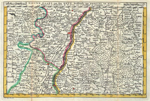
Nieuwe Kaart van den Rhyn, Strekkende van Fribourg tot Haguenau.
$225.00
Acquire
- Digital Map Information
- Suitable for large format printing
- DPI: 300
- File Size: 3.66 MB
- File Type: ZIP / TIFF
- ICC color profile embedded
- Delivered instantly via download link
A stunning map of Alcase, France drawn by J. Ratelband in 1735. Includes both Basse Alsace and Haute Alsace. Covers from Fribourg in the northwest, eastward past Strasbourg and the Rhine River as far as Rordorff and Kilberg. Dutch language title along the top ... (more details)
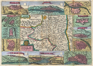
Caarte de Dauphine.
$225.00
Acquire
- Digital Map Information
- Suitable for large format printing
- DPI: 300
- File Size: 3.76 MB
- File Type: ZIP / TIFF
- ICC color profile embedded
- Delivered instantly via download link
A stunning map of Dauphine, France first drawn by Daniel de la Feuille in 1706. This province in southeastern France roughly corresponds with the modern day departments of Isère, Drôme, and Hautes-Alpes. Surrounded by twelve views of important villages and ... (more details)