This copy is copyright protected.
Copyright © 2024 Geographicus Rare Antique Maps
1851 Stulpnagel Map of the Eastern United States
UnitedStates-stulpnagel-1851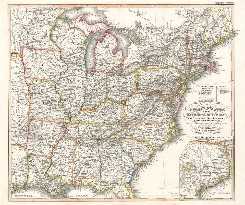

Johann Friedrich von Stülpnagel (March 13, 1786 - October 18, 1865) was a Prussian cartographer and military officer. He joined the Old Prussian Infantry Regiment No. 7 under the command of Carl Philipp von Owstin in August 1804, became and ensign in December 1806 and a second lieutenant in June 1807. He married Sophie Charlotte Keßler (1791 - 1866) in 1810, with whom he had ten children, eight of which survived him. During Napoleon's 1812 Russian campaign, von Stülpnagel was captured by the Russians at the end of November 1812. He participated in nearly every campaign between 1806 and 1815 and fought in Germany, Russian, the Netherlands, and France. He was forced to retire from the army in 1822 after an ear ailment caused him to become almost totally deaf. At this point, not being a wealthy individual, he moved to Wandersleben and started working as a draftsman for Justus Perthes, the geographic publisher, in 1823. At Justus Perthes he worked with Adolf Stieler on his 'Handatlas'. Von Stülpnagel soon ranked among one of the 'pillars of the business' and drafted numerous supplementary sheets and corrections for the Handatlas. Stülpnagel officially retired from the army on September 10, 1835 as a captain. Stülpnagel moved to Gotha after Stieler's death in 1836 and continued to work on Stieler's Handatlas with Heinrich Berghaus and Joseph Christoph Bär. He worked less and less beginning in 1863 because of age-related complaints. Von Stülpnagel died at seventy-nine years old and left behind his wife and eight children. More by this mapmaker...
Adolf Stieler (1775 – 1836) was a German cartographer who worked most of his life in the Justus Perthes Geographical Institute in Gotha. His atlases are deservedly held in high esteem for their excellence. His Handatlas was the leading German world atlas until the middle of the 20th century, parts of which were printed until 1944. Learn More...
Johan Georg Justus Perthes (September 11, 1749 - May 2, 1816) was one of the most important German cartographic engravers of the 19th century. He was born in the Thuringian town of Rudolstadt, the son of a court physician. In 1778, he began working as a bookseller in Gotha. Perthes began his publishing empire shortly thereafter with the 1784 issue of the famed survey of European nobility known as the Almanac de Gotha. In the next year, 1785, he founded the cartographic firm of Justus Perthes Geographische Anstalt Gotha. His son Wilhelm Perthes (1793 - 1853) joined the firm in 1814. Wilhelm had prior publishing experience at the firm of Justus Perthes' nephew, Friedrich Christoph Perthes, who ran a publishing house in Hamburg. After Justus Perthes died in 1816, Wilhelm took charge and laid the groundwork for the firm to become a cartographic publishing titan. From 1817 to 1890. the Perthes firm issued thousands of maps and more than 20 different atlases. Along with the visionary editors Hermann Berghaus (1797 - 1884), Adolph Stieler (1775 - 1836), and Karl Spruner (1803 - 1892), the Perthes firm pioneered the Hand Atlas. When Wilhelm retired, management of the firm passed to his son, Bernhardt Wilhelm Perthes (1821 – 1857). Bernhardt brought on the cartographic geniuses August Heinrich Peterman (1822 - 1878) and Bruno Hassenstein (1839 - 1902). The firm was subsequently passed to a fourth generation in the form of Berhanrd Perthes (1858 – 1919), Bernhard Wilhelm's son. The firm continued in the family until 1953 when, being in East Germany, it was nationalized and run as a state-owned enterprise as VEB Hermann Haack Geographisch-Kartographische Anstalt Gotha. The Justus family, led by Joachim Justus Perthes and his son Wolf-Jürgen Perthes, relocated to Darmstadt where they founded the Justus Perthes Geographische Verlagsanstalt Darmstadt. Learn More...
Copyright © 2024 Geographicus Rare Antique Maps | Geographicus Rare Antique Maps
This copy is copyright protected.
Copyright © 2024 Geographicus Rare Antique Maps