This item has been sold, but you can get on the Waitlist to be notified if another example becomes available, or purchase a digital scan.
1802 Arrowsmith Map of Africa
Africa-arrowsmith-1802$175.00

Title
Africa.
1802 (undated) 9.84 x 12.6 in (24.9936 x 32.004 cm)
1802 (undated) 9.84 x 12.6 in (24.9936 x 32.004 cm)
Description
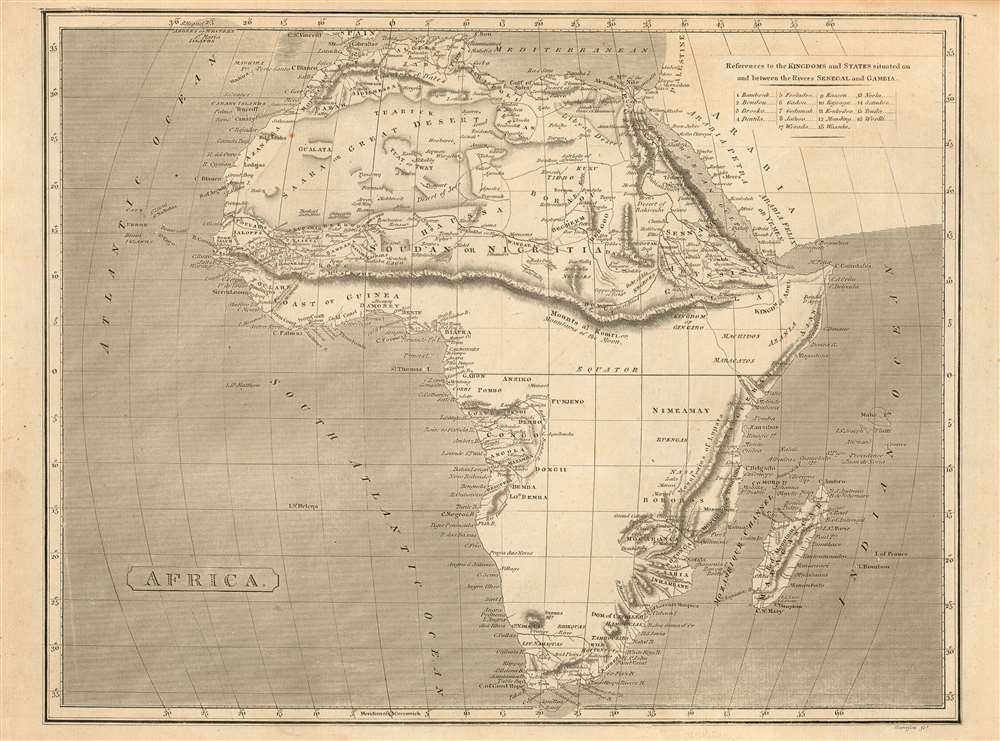
This fascinating 1802 Arrowsmith map of Africa shows the results of first African expeditions of Scottish explorer Mungo Park, contrasting these with the vast expanses of Africa of which Europeans remained utterly ignorant. Virtually all of the information in this map pertaining to Western Africa reflects Park's 1795-97 exploration up the Gambia, into the interior, and along the Niger River. Park hard presumed the Niger to have its headwaters in a mountain range separating the Gold, Ivory and Slave coasts from north Africa: this mythical range, the Mountains of Kong, are shown here prominently; they extend eastward and connect with the equally mythical Mountains of the Moon, which were presumed by Ptolemy, and virtually every cartographer until well into the 19th century, to be the location of the source of the Nile.
Publication History
This map appears to be rare; at any rate, it is scarce on the market and is neglected in institutional collections, with OCLC revealing examples only in New York Public Library and Princeton University. Arrowsmith produced a similar map entirely re-engraved and published by Longman in 1807.Cartographer
Aaron Arrowsmith (1750-1823), John Arrowsmith (1790-1873), and Samuel Arrowsmith. The Arrowsmith family were noted map engravers, publishers, geographers, and cartographers active in the late 18th and early 19th century. The Arrowsmith firm was founded by Aaron Arrowsmith, who was trained in surveying and engraving under John Cary and William Faden. Arrowsmith founded the Arrowsmith firm as a side business while employed by Cary. The firm specialized in large format individual issue maps containing the most up to date and sophisticated information available. Arrowsmith's work drew the attention of the Prince of Wales who, in 1810, named him Hydrographer to the Prince of Wales, and subsequently, in 1820, Hydrographer to the King. Aaron Arrowsmith was succeeded by two sons, Aaron and Samuel, who followed him in the map publication business. The Arrowsmith firm eventually fell to John Arrowsmith (1790-1873), nephew of the elder Aaron. John was a founding member of the Royal Geographical Society. The firm is best known for their phenomenal large format mappings of North America. Mount Arrowsmith, situated east of Port Alberni on Vancouver Island, British Columbia, is named for Aaron Arrowsmith and his nephew John Arrowsmith. More by this mapmaker...
Condition
Very good condition. Light toning.
References
OCLC 62317289. Not in Afriterra.