This item has been sold, but you can get on the Waitlist to be notified if another example becomes available.
1960 / 1966 Admiralty Chart of Hong Kong Harbor
HongKongHarbor-admiralty-1966$700.00


Title
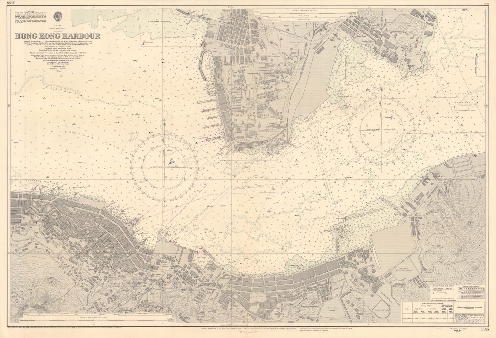
China South East Coast, Hong Kong Harbour.
1966 (dated) 27.25 x 40 in (69.215 x 101.6 cm) 1 : 6080
1966 (dated) 27.25 x 40 in (69.215 x 101.6 cm) 1 : 6080
Description
A splendid nautical map of Victoria Harbour in Hong Kong, produced by the British Admiralty's Hydrographic Office in 1966. It provides a detailed picture of the harbor, the heart of Hong Kong, and the lands to either side.
A wealth of nautical information is indicated, including soundings, compasses with magnetic variations, anchorages, lights, hazards, shoals, buoys, and more. Handwritten annotations within the compass at left were likely added in the months after the chart's printing in 1966. Nearby, a printed annotation notes the location of an ocean terminal built near Kowloon Railway Station. The adjoining passenger and ferry piers, dedicated to the iconic Star Ferry, were at the time the only means of mass transit between Kowloon and Hong Kong Island. The chart's assiduous attention to detail was warranted. At the time, the harbor teemed with ships of various types, sizes, and ages, engaged in transportation, trade, fishing, and leisure activities.
A Closer Look
Compared to similar Admiralty charts of Hong Kong (such as 'Hong Kong Waters East' and 'Hong Kong Waters West,' also sold by us), the present chart focuses squarely on Victoria Harbor, that is, the waters between the tip of the Kowloon Peninsula (Tsim Sha Tsui) and the most developed part of Hong Kong Island (then known as Victoria, now the neighborhoods of Central and Wan Chai). The reduced scale employed here allows a fantastic level of detail, down to individual buildings, including schools, government offices, hospitals, barracks, diplomatic missions, houses of worship, markets, warehouses, and more. The basic layout of the city is easily recognizable and some areas retained particular functions even after undergoing major changes, such as the dedication of the area around Morrison Hill to sporting facilities. Land reclamation and the leveling of hills has resulted in notable changes in the coastline and topography of the city. In particular, the shallow waters shaded blue here have been filled in to free up space in the densely-packed city.A wealth of nautical information is indicated, including soundings, compasses with magnetic variations, anchorages, lights, hazards, shoals, buoys, and more. Handwritten annotations within the compass at left were likely added in the months after the chart's printing in 1966. Nearby, a printed annotation notes the location of an ocean terminal built near Kowloon Railway Station. The adjoining passenger and ferry piers, dedicated to the iconic Star Ferry, were at the time the only means of mass transit between Kowloon and Hong Kong Island. The chart's assiduous attention to detail was warranted. At the time, the harbor teemed with ships of various types, sizes, and ages, engaged in transportation, trade, fishing, and leisure activities.
Publication History and Census
This chart was initially published by the Admiralty in 1916 and updated regularly thereafter, with new editions appearing to 1949, major corrections to 1960, and minor corrections to 1966. The 1960 printing of the chart is only known to be held by the National Maritime Museum (U.K.), while the University of Chicago holds an example dated to 1958 (OCLC 904771444).Cartographer
The British Admiralty Office (1795 - Present) or the United Kingdom Hydrographic Office refers to the Branch of the English government that is responsible for the command of the British Navy. In 1795 King George III created the United Kingdom Hydrographic Office, known in short as the U.K.H.O., to provide top notch nautical charts to the vast Royal Navy. Prior the founding of the Admiralty the surveying and creation of nautical charts was primarily a commercial venture wherein the cartographer himself, more of than not, actually financed the printing of his own material. The great navigator Cook himself is known to have scrambled for funds to publish his own seminal charts - the most important and advanced of the period. The system of privately funded nautical mapping and publishing left vast portions of the world uncharted and many excellent charts unpublished. King George III, responding significant loss in trade revenue related to shipwrecks and delay due to poor charts, recognized the need for an institutionalized government sponsored cartographic agency - the Admiralty. The first head of the Admiralty, a position known as Hydrographer, was the important cartographer Alexander Dalrymple. Dalrymple started by organizing and cataloging obtainable charts before initiating the laborious process of updating them and filling in the blanks. The first official Admiralty Chart appeared in 1800 and detailed Quiberon Bay in Brittany. By 1808 the position of Hydrographer fell to Captain Thomas Hurd. Hurd advocated the sale of Admiralty charts to the general public and, by the time he retired in 1829, had issued and published some 736 charts. Stewardship of the organization then passed to Rear Admiral Sir Francis Beaufort. It was under Beaufort's administration that the Admiralty truly developed as a "chart making" as opposed to a "chart cataloging" institution. Beaufort held his post from 1829 to 1854. In his 25 years at the Admiralty Beaufort created nearly 1500 new charts and sponsored countless surveying and scientific expeditions - including the 1831 to 1836 voyage of the H.M.S. Beagle. By 1855 the Admiralty's chart catalog listed some 1,981 charts. More by this mapmaker...
Condition
Excellent.
References
OCLC 538236121.