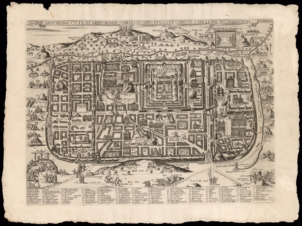
Title
L'antichissima città di Gierusalemme come era nei tempo di N.S. Gisu Christo, con le sue dechiaratione.
1595 (undated)
14.75 x 20 in (37.465 x 50.8 cm)
Description
This is a rare, separately-issued Lafreri-school broadsheet map of Jerusalem, printed c. 1595 by Matteo Florimi. It is an iteration of the influential 1584 Adrichem plan, itself an allegorical depiction of Jerusalem during Christ's lifetime, instrumental in codifying elements of Christian veneration of the Holy City, in particular the Stations of the Cross.
A Closer Look
For such a work, the physical geography of Palestine and Jerusalem was not as relevant as conformity to scripture, and in this respect the map is unparalleled in its usefulness. The Holy City is portrayed in a rectilinear form, divided into three major historical zones. At the bottom of the engraving, 134 locations are listed in fourteen columns, guiding the reader to Biblical events both inside the city and out.Stations of the Cross
More importantly, Adrichem cartography was instrumental in codifying elements of Christian veneration of the Holy City, in particular the Stations of the Cross. Catholic practice had, since the Middle Ages, incorporated the reenactment by the faithful of the Via Dolorosa, the route followed by Jesus on the day of Crucifixion. Pilgrims to Jerusalem would follow the route through the Holy Land, but with the expansion of the Turkish Empire such travel was impossible for most. Many Christian cities began to assemble pilgrimage routes locally to allow pilgrims to follow a metaphorical Via Dolorosa without dangerous travel to distant lands. Churches and cathedrals would illustrate the Stations of the Cross - the different scenes along the Via Dolorosa - in their architecture and decoration. There was little system to this, however, and broad differences between different localities. Adrichem's text and plan of Jerusalem provided a model that all could follow, and that the faithful could practice even from the comfort of home, in a sort of 'Pilgrimage of the Mind.'Maps of the 'Lafreri' School
Between 1544 and the 1590s, Rome and Venice saw the production of a number of elegant, rare, and consequently now sought-after maps. These are frequently classified collectively as belonging to the 'Lafreri-School,' a term often used due to the survival of a 1572 catalogue of maps from the stock of publisher Antonio Lafreri. The close resemblance of this list to the contents of various bound collections of Roman and Venetian maps of the period led to these proto-atlases to be attributed to Lafreri, despite the maps having been actually produced by over a dozen different mapmakers, including Gastaldi, Lafreri himself, his heir Duchetti, the Bertellis, Camochio, Zenoni, Salamanca, Forlani, Florimi, Ligorio, Tramezini, Zaltieri and others. These cartographers, mapmakers, engravers, and publishers, some of whom shared formalized partnerships, left behind a legacy of some six or seven hundred maps, all of which are marked by scarcity due to their not having been included in a standard atlas. Though these were generally sold in assembled-to-order, composite 'atlases,' the contents of these works varied wildly and those that survive are often poorly catalogued. Since the maps in these composite works were not intended to be compatible with one another, bookbinders had to go to sometimes extreme lengths to combine them: pasting smaller maps down to larger sheets with were then stitched into the books, larger maps trimmed close and then folded to fit smaller bindings. We have also encountered some maps, usually found separately, yet printed to the same sheets to be included together in bound works.
The popularity of these works, and their utility, appear to have influenced Ortelius in his project of creating the first true, uniform atlas in 1570. Despite the proliferation of Italian mapmakers in the 1560s and 70s, only a few appear to have lived beyond the Italian plagues of 1575-77, and these survivors seem to have prospered mainly by their acquisition of plates engraved prior to those plagues. The absence of any Italian response to Ortelius' work is more likely to have been a product of the devastation wrought by the pestilence than any overwhelming superiority of the Flemish work.Publication History and Census
This single-sheet iteration of Adrichem's plan was executed by, or on behalf of the Siena printed Matteo Florimi, for sale as a separate sheet: indeed, this example's deckled edges and the absence of a fold indicates that this sheet has never been bound in a book. It is faithful to Adrichem, possibly via the work of Giacomo Franco. It is likely no earlier than 1590 and the conjectural date of 1595 is suggested by van der Heijden. Bifolco and Ronca lean towards a date of closer to 1600. The engraving does not appear in Laor and there are no confirmed further editions by Florimi, although Bifolco and Ronca note the existence of a later strike by Petrucci, who acquired most of Florimi's plates after his death. A single example of the map is listed in OCLC, catalogued by the British Library with a date of 1600.
CartographerS
Matteo Florimi (1540 – April 13, 1615) was an Italian print seller, book dealer, printer, and publisher. Florimi was born in Calabria around 1540. He relocated to Siena around 1501 where he established a prosperous workshop known or books, allegorical prints, floral prints, and maps. Around 1600 he acquired the services of Arnoldo di Arnoldi, a map engraver previously employed with Giovanni Antonio Magini. In that same year, Magini accused Florimi of plagiarism, an event that is most likely associated with Arnoldi's defection. In the years 1605-1608, Florimi received financial support from Ottavio Cinuzzi. He was also known to be close friends with the Italian mannerist painter Francesco Vanni. Florimi's cartographic work is often found in Lafreri atlases. Florimi was survived by his four children, Giovanni, who continued his father's workshop under the imprint 'Eredi Florimi'; Francesco, Cecila, and Caterina. More by this mapmaker...
Christian Kruik van Adrichem (February 13, 1533 - June 20, 1585), alternatively known as Christianus Crucius Adrichomius was a Dutch theologian active in the second half of the 16th century. Adrichem was born in Delft of a wealthy family - at one point his father, Adriaen Claesz, was mayor of Delft. Adrichem was ordained in 1566. He served as the director of the Convent of St. Barbara in Delft until expelled by the Protestant Reformation. Fleeing the anti-Catholic sentiment of the Reformation, Adrichem reestablished himself in Cologne (Koln) where compiled various religious works including his important historical atlas, the Theatrum Terrae Sanctae et Biblicarum Historiarum. Adrichem's important atlas was published posthumously by his associate Gerardis Brunius in 1590. The work went through numerous editions and served as the foundation of most subsequent maps of the Holy Land well into the 18th century. Learn More...
Condition
Excellent. Wide margins with deckled edges. Strong platemark, no folds.
References
OCLC 1065329489. Not in Laor. Bifolco, S. and Ronca, F., Cartografia e Topografia Italiana del XVI Secolo Vol. 1, map 205.