This item has been sold, but you can get on the Waitlist to be notified if another example becomes available, or purchase a digital scan.
1650 Fuller Map of Jerusalem ( Israel, Palestine, Holy Land)
jerusalem-fuller-1650$600.00

Title
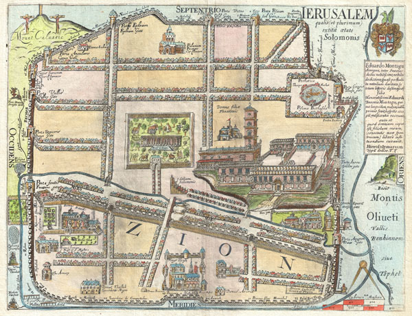
IERUSALEM qualis (ut plurimum) extitit ætate Solomonis
1665 (undated) 11.5 x 15 in (29.21 x 38.1 cm)
1665 (undated) 11.5 x 15 in (29.21 x 38.1 cm)
Description
An extremely rare and altogether fascinating 1650 map of Jerusalem by Thomas Fuller. Depicts the old walled city of Jerusalem during the reign of the Biblical King Solomon, ca. 961-922 BC. On the whole this is a highly imaginative map of the city and likely bears no significant resemblance to the Jerusalem of Solomon. Solomon's Temple appears at the right center with a tall bell tower and a highly Renaissance European design aesthetic. At the center, roughly where the Church of Holy Sepulture is located today, is Solomon's menagerie. The Baths of Bethesda, in which an angel swims, appear in the upper right, approximately where they are said to be today. Other sites of note include 'Domus David' near the modern day Jaffa Gate, the armory in the lower left, the Kings House at bottom center, Solomon's throne near the menagerie at center, the golden gate at right center, etc. Throughout the streets are arranged with an uncanny geometric precisions. Outside the walls Fuller identifies the Mount of Olives (Montis Oliueti), the Dragon Well, the Fullers Field, the King's Garden, and despite purportedly being a map of Solomon's Jerusalem, the Crucifixion on Calvary. A armorial crest and a dedication to Eduardo Montagu, or Edward Montagu, the First Earl of Sandwich, appears in the upper right quadrant. Engraved by John Williams for the 1650 first edition of Thomas Fuller's A Pisgah-sight of Palestine. This map is exceptionally rare and an important addition to any serious Israel - Palestine - Holy Land collection. We have found no record of it appearing on the market in the last 10 years.
Cartographer
Thomas Fuller (1608 - August, 16, 1661) was an English historian and Anglican clergyman. Fuller was born in Northamponshire, England and was educated at Queens College, Cambridge. A prodigal student, Fuller was describe by contemporary John Aubrey as "a boy of pregnant wit". He entered the Anglican clergy and became well known throughout England for his prodigious speaking skills, which kept him moving from town to town for much of his career. Fuller is also significant as he was one of the first Englishmen able to support himself solely through the publican and sale of his written works, which include The Worthies of England, The Historie of the Holy Warre, The Holy State and the Prophane State and his prominent geography of the Holy Land, A Pisgah-Sight of Palestine. The Oxford Dictionary of National Biography describes Fuller's personality,
His power of fascinating posthumous as well as contemporary friends is easily explicable. His unfailing playfulness, the exuberant wit, often extravagant, rarely ineffective and always unforced, is combined with a kindliness and simplicity which never fails to charm. If not profound, he is invariably shrewd, sound-hearted, and sensible. He tells a story admirably, as Lamb observed, because with infectious enjoyment. His humour is childlike in its freedom from bitterness. His quick sense of the ridiculous, combined with a calm and cheerful temperament, made fanaticism impossible. It tempered his zeal instead of edging his animosities. Moderation was therefore his favourite virtue, or 'the silken chain running through the pearl-string of all the virtuesFollowing an illustrious career, Fuller contracted Typhus fever and died at his home in Covent Garden on the 16th of August, 1661. Fuller was survived by several children from his two marriages. More by this mapmaker...
Source
Fuller, Thomas, Pisgah-Sight Of Palestine And The Confines Thereof, With The History of the Old and New Testament acted thereon., 1650.
Condition
Very good condition. Original centerfold. Minor darkening lower left quadrant.
References
Laor, E., Maps of the Holy Land: Cartobibliography of Printed Maps, 1475 - 1900, 1024. The George Washington University, The Gelman Library, Special Collections Research Center, MAP0002.