This item has been sold, but you can get on the Waitlist to be notified if another example becomes available, or purchase a digital scan.
1780 Raynal / Bonne Map of South Africa, Zimbabwe, Madagascar, and Mozambique
Mozambique-bonne-1780-2$87.50

Title
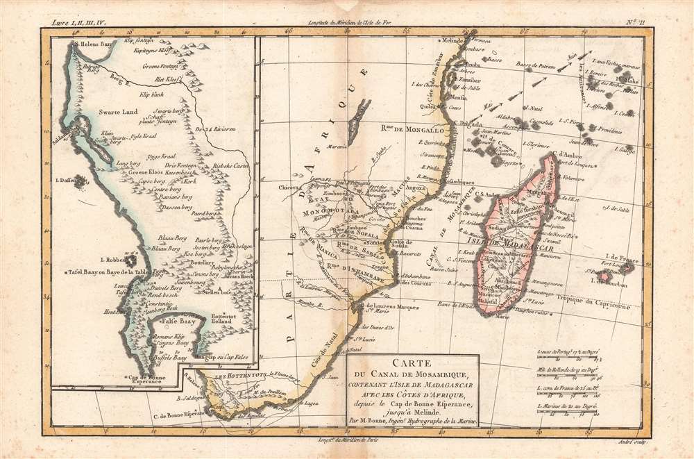
Carte du Canal de Mosambique.
1780 (undated) 8.25 x 12.25 in (20.955 x 31.115 cm) 1 : 18000000
1780 (undated) 8.25 x 12.25 in (20.955 x 31.115 cm) 1 : 18000000
Description
A superb example of Rigobert Bonne and Guillame Raynal's 1780 map of Southern Africa. It is essentially two maps in one, covering the entire southern portion of the continent.
Offshore, Madagascar and the many Indian Ocean islands surrounding it are well mapped with considerable, though inaccurate, inland detail. Arrows show the direction of tradewinds and dotted lines identify some offshore reefs and other dangers.
The secondary map, occupying the left-hand quadrants of the chart, details Dutch claims in the western part of South Africa from the Cape of Good Hope north as far as St. Helens Bay. Various indigenous groups, forts, mountain ranges, and rivers are noted, as is Robben Island, later famous for the notorious prison used by the apartheid regime to house political opponents, including Nelson Mandela.
A Closer Look
The main map, on the right, covers from the Cape of Good Hope north as far as Zanzibar and modern-day Kenya, focusing on the formerly gold rich kingdom of Monomotapa. This region, today part of Mozambique and Zimbabwe, was often associated with the Biblical kingdom of Ophir, which is mentioned in the legend of King Solomon's Mines. This was one of the first parts of eastern Africa to be explored and colonized by Portuguese traders looking for a source of gold to rival that of the Spaniards in Mexico and Peru. However, the 'Mines of Solomon' had been mostly exhausted shortly before the Europeans arrived. Just north of Monomotapa, a very embryonic mapping of Lake Malawi appears with no defined northern terminus.Offshore, Madagascar and the many Indian Ocean islands surrounding it are well mapped with considerable, though inaccurate, inland detail. Arrows show the direction of tradewinds and dotted lines identify some offshore reefs and other dangers.
The secondary map, occupying the left-hand quadrants of the chart, details Dutch claims in the western part of South Africa from the Cape of Good Hope north as far as St. Helens Bay. Various indigenous groups, forts, mountain ranges, and rivers are noted, as is Robben Island, later famous for the notorious prison used by the apartheid regime to house political opponents, including Nelson Mandela.
Publication History and Census
This map was drawn by Bonne for Raynal's Atlas de Toutes les Parties Connues du Globe Terrestre, Dressé pour l'Histoire Philosophique et Politique des Établissemens et du Commerce des Européens dans les Deux Indes. It was engraved by Gaspard André, an individual about whom little is known (not to be confused with the 19th century architect of the same name). Both the map itself and the entire atlas in this edition are held by numerous libraries in North America and Europe.CartographerS
Rigobert Bonne (October 6, 1727 - September 2, 1794) was one of the most important French cartographers of the late 18th century. Bonne was born in Ardennes à Raucourt, France. He taught himself mathematics and by eighteen was a working engineer. During the War of the Austrian Succession (1740 - 1748) he served as a military engineer at Berg-op-Zoom. It the subsequent years Bonne became one of the most respected masters of mathematics, physics, and geography in Paris. In 1773, Bonne succeeded Jacques-Nicolas Bellin as Royal Cartographer to France in the office of the Hydrographer at the Depôt de la Marine. Working in his official capacity, Bonne compiled some of the most detailed and accurate maps of the period - most on an equal-area projection known erroneously as the 'Bonne Projection.' Bonne's work represents an important step in the evolution of the cartographic ideology away from the decorative work of the 17th and early 18th century towards a more scientific and practical aesthetic. While mostly focusing on coastal regions, the work of Bonne is highly regarded for its detail, historical importance, and overall aesthetic appeal. Bonne died of edema in 1794, but his son Charles-Marie Rigobert Bonne continued to publish his work well after his death. More by this mapmaker...
Guillaume Thomas Raynal (April 12, 1711 - March 6, 1796) was a French writer, philosopher, and historian active during the Enlightenment. Raynal was educated as a Jesuit, but left the order for unknown reasons, and moved to Paris where he dedicated himself to the production of a number of minor but popular historical works. Raynal's histories opened doors to elite social and artistic circles where he met and befriended various members of the Philosophe Coteries. Raynal's most important work is generally considered to be a 1770 collaboration with Diderot and others entitled, L'Histoire philosophique et politique des établissements et du commerce des Européens dans les deux Indes. Some of the philosophical ideas developed in the book drew negative attention from the authorities who banned the book and posted a notice for the arrest of its authors. Raynal fled to Berlin and later to St. Petersburg, where he lived for a number of years before returning to France in 1787. Though not a cartographer Raynal's name is often attached to several Atlases by Rigobert Bonne, from whom he composed the text. Learn More...
Source
Raynal, G., Atlas de Toutes les Parties Connues du Globe Terrestre, Dressé pour l'Histoire Philosophique et Politique des Établissemens et du Commerce des Européens dans les Deux Indes, (Paris) 1780.
Condition
Good. Reinstated wormholing at top center, confined to margins.. Some discoloration along fold line and foxing in the margins, especially at bottom.
References
Rumsey 3083.026, OCLC 244484741, 20574023.